Categories
News Politics Transportation

ODOT Looking For Public Feedback on Reworked Eastern Corridor Program

The Ohio Department of Transportation is looking for additional feedback related to transportation improvements for Cincinnati’s eastern neighborhoods and far reaching suburbs.

The survey comes after ODOT has said that they are backing away from original plans for the hotly debated Eastern Corridor project, which came under public scrutiny for its scope and potentially negative impact to established neighborhoods on the city’s east side.

While the project will most certainly not be moving forward as originally envisioned, public officials are still looking to get a grasp on what kinds of investments could be made to improve traffic congestion and mobility options.

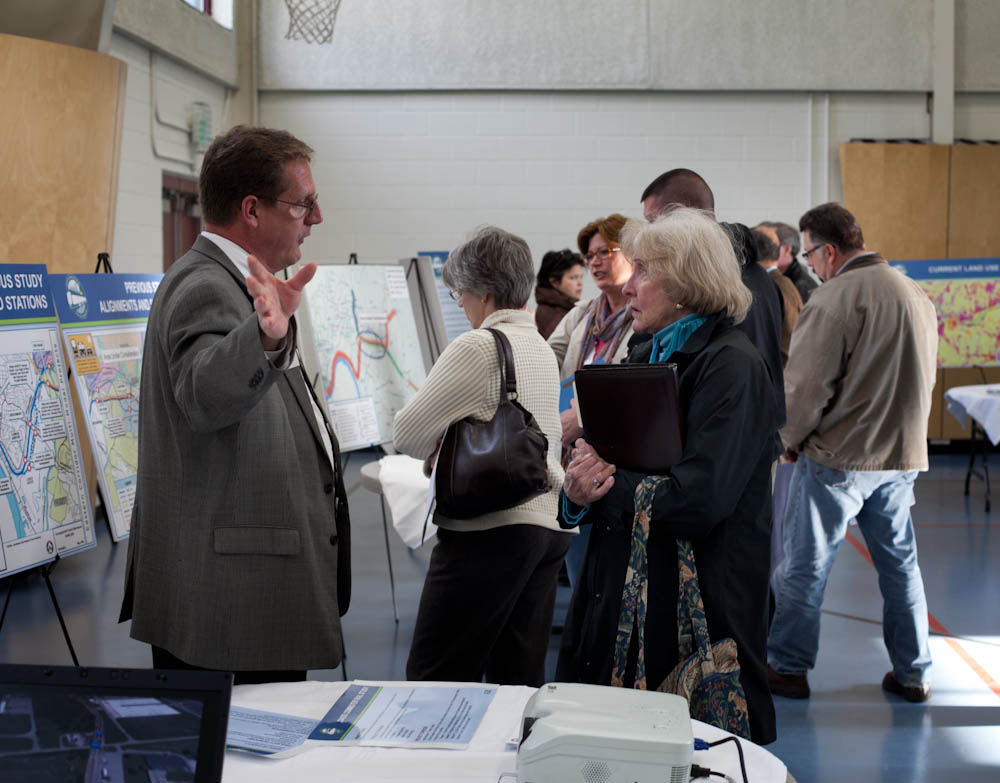
So far, ODOT has held public meetings in Newtown and Mariemont, and will hold meetings in Anderson Township, Mt. Lookout, Fairfax and Mt. Washington in the coming weeks – the next of which will occur this evening, from 6pm to 8pm, in Mt. Lookout at Christ The King Parish Center at 927 Ellison Avenue.

Those unable to attend that or the other upcoming meetings, are being encouraged to complete an interactive web-based survey. Taking approximately five to 10 minutes to complete, the survey asks respondents to rank the importance of the types of transportation improvements needed for the corridor, while also asking for specific location-based improvement suggestions.

The survey and public feedback for this effort is focused on what ODOT calls Segments II and III of the project, and is not limited to those who live or work in the study area, but rather open to anyone who finds themselves passing through the area.

Early results from the survey show that respondents want ODOT to focus investments on improving public transit, biking and walking options, and travel time through the corridor. While the travel time option could mean many different things, it may be connected to the other two top rankings for multi-modal transportation enhancements.

Projects not specifically mentioned in the survey include the Oasis Corridor commuter rail line, which also has been on the ropes lately, and the Wasson Corridor, which is still unclear how it will proceed with respects to a trail only, or a light rail and trail combination.

As UrbanCincy wrote in June 2015, a new local access bridge crossing the Ohio River, from Columbia Tusculum to Dayton, KY, could also greatly help solve access and congestion issues on the east side of the region.

ODOT officials say that the online survey will remain open until Wednesday, June 15. After this evening’s open house in Mt. Lookout, the next meetings to take place in Fairfax and Mt. Washington will occur on May 4 and May 5, respectively.
Categories
News Politics Transportation

OKI Survey Results Show Cincinnati Region Wants More Transportation Choices

The OKI Regional Council of Governments recently released survey results affirming the region’s desire for more public transportation and other carless commuting alternatives.

The survey was part of the organization’s public involvement in their 2040 Regional Transportation Plan, which will ultimately set the priorities for the metropolitan planning organization as it looks to distribute federal funding for transportation.

OKI has conducted several surveys to gather feedback on the plan, each one confirming similar desires for more non-automobile transportation options.

The vast majority of the respondents stated that their most frequent mode of transportation is driving their vehicle alone, with only 2% taking the bus and the same amount walking.

In the only open-ended question of the survey, OKI asked what part of their commute to work or school or some other frequent route could be improved. While a common theme was complaints on the massive reconstruction of the Mill Creek Expressway on I-75, respondents also called for a light rail system connecting the region’s suburbs and airport.

Those surveyed complained about a lack of coverage and frequency of Metro bus routes. A universal fare card for TANK and Metro, which is something area transit leaders have been developing. Altogether, 15% of respondents wanted more public transportation options and 11% wanted to improve the transit options that already exists.

While the survey results reinforce the notion that the car reigns supreme in Cincinnati, it also shows that area residents have few, if any, alternatives. As such, more than 56% of respondents said that they would keep their car, but drive much less if non-vehicle modes of transportation were available.

Officials at OKI have recently taken criticism for the planning assumptions they have been using to develop their regional plans, which often include VMT increases that have not been realized in many years.

Survey respondents said they were most concerned about traffic congestion and the lack of public transportation over the next 25 years. Should regional leaders decide to focus transportation investments on building transit, they could seemingly address both concerns at the same time.

Another them that came out of the survey results was that public officials should focus spending resources on maintaining and fixing outdated infrastructure, rather than building new capacity. The idea of institutionalizing “fix-it-first” policies is one that has garnered bi-partisan support across the country, including Ohio.

OKI has conducted several surveys of similar nature over recent years as the work to update and develop their regional plans. Despite the frequency of such surveys, the results have been consistent along the way, with many people asking for more transportation choices and better maintained infrastructure.

“This feedback is providing valuable insight into the transportation needs and issues most important to the public,” officials explained. “It is helping us identify projects that should be recommended for inclusion in the plan.”

The 2016 update to the OKI 2040 Regional Transportation Plan, which includes a recommended project list, is scheduled to be reviewed by OKI’s Board of Directors in June.

Categories
Development News Transportation

Cincinnati DOTE Aiming to Narrow Liberty Street Redesign to Two Alternatives

Tomorrow night will be the second meeting of the Liberty Street Safety Improvement Study – an effort previously called the Liberty Street Complete Street Project in its 2013 iteration.

At the meeting, Cincinnati’s Department of Transportation & Engineering will present various concepts for the street’s reconfiguration, including five separate options at seven lanes, and additional six, five, four and three-lane options. Many of these scenarios contribute enough additional space to make development on the south side of Liberty Street feasible.

A major consideration, as the project’s title would suggest, is the safety of pedestrians and bicyclists that share the roadway. The current excessive width of the road, coupled with the speed of cars, contributes to an environment incongruous to pedestrian and cyclist safety.

Other elements being considered include pedestrian and cycling facilities, development potential on the south side of Liberty Street, streetscape aesthetics, automobile capacity/safety, and the preservation of on-street parking.

Both current and past public input, like the 2011 Brewery District Master Plan, stress a strong desire to improve the connection of urban fabric between the northern and southern portions of Over-the-Rhine.

“Liberty Street cuts off two sections of OTR,” said Frank Henson, a local cycling advocate. “All other north-south routes get cut up by the expansive width of Liberty; and I support narrowing it, with the inclusion of space for bicycle facilities.”

Many believe that the narrowing of Liberty Street can accomplish both of these objectives; although questions remain about how much narrowing is appropriate, and what should be done with the additional space that is made available.

According to data from the OKI Regional Council of Governments, Liberty Street has an annual average daily traffic (AADT) count of 14,278, which is actually less than the much narrower Ludlow Avenue’s 14,551 AADT in Clifton.

Ludlow Avenue has parking on both sides of the street, aside from peak hours from 7am to 9am where it is prohibited on the south side of the road, and 4pm to 6pm where it is prohibited on the north side of the road. This means that Ludlow Avenue, with its nearly identical traffic count, has fewer lanes of traffic during both peak and non-peak hours.

Martin Luther King Drive, near the University of Cincinnati’s main campus, has the same width as Liberty Street, but carries upwards of 20,000 AADT; and portions of Reading Road carry more than 25,000 AADT with just five lanes.

As a result, one could then deduce that travel demand on Liberty Street is far, far less than its width warrants.

Should Liberty Street be significantly narrowed, based on these figures, it could still absorb its current capacity, and, if necessary, divert traffic to Central Parkway, Fort Washington Way, or one of the many east-west thoroughfares that also have highway access.

Option 7d includes a “shared use bicycle/pedestrian pathway;” and while this widened path is intended to accommodate both pedestrians and cyclists, it is generally considered a less safe practice, as compared to separate facilities, to mix the two due to the faster travel speeds of people on bicycles.

An option that has bike and pedestrian facilities, preserves on-street parking, while also providing three travel lanes could reduce speed, increase safety, provide additional space for development, and still manage capacity based on comparable traffic counts.

The Ludlow Avenue and Reading Road examples disprove the idea that any decrease in capacity would be crippling. However, should demand increase, traffic is also highly divertible to other thoroughfares within a short distance.

Residents and interested parties can express their opinions on Tuesday, March 1 from 6pm to 8pm at the Woodward Theater in Over-the-Rhine. City officials say that they hope to narrow the alternatives to two following this meeting.

Categories
News Transportation

How Do You Want OKI To Shape Future of Region’s Transport Network?

The OKI Regional Council of Governments is in the midst of updating its 2040 Regional Transportation Plan. In the early stages of developing this plan, they region’s designated metropolitan planning organization is looking for feedback regarding the types of transportation and land use policies it pursues over that time.

As of now, agency officials are looking for public feedback in the form of an online survey that takes less than five minutes to complete. It asks the public what kinds of transportation modes should be prioritized, where the region’s transportation network is lacking, whether maintenance or expansion should be prioritized, and how you currently and would like to get around for your daily needs.

Planners at OKI say that the results of this public input will help define what types of transportation improvement recommendations are made in June 2016. This is critically important since OKI serves as the regional authority in charge of administering federal transportation dollars.

Over the past four years this has included $86.3 million for 77 roadway projects, $22.9 million for 12 transit capital improvements, and $6.6 million for 15 bicycle and pedestrian projects.

As with any planning exercise, the OKI 2040 Regional Transportation Plan (2016 Update) is based on a number of factors to help guide decision-making.

One of the most important baseline factors is population growth and the distribution thereof. For this, OKI is using 2010 Census data, and its preceding decades, as the baseline for future forecasting.

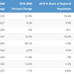
As a result, OKI is projecting that Hamilton County will lose 2% of its population between now and 2040, thus resulting in a loss of regional population share from its 40.1% today, to 35.4% in the future. In fact, based on those prior trends, OKI believes that Hamilton County’s population will stand at approximately 790,000 in 2020 – down from the 802,374 baseline in 2010.

The problem with using these historical trends is that Cincinnati has seen a dramatic turnaround over the past decade – one that has reversed Cincinnati and Hamilton County’s long population loss trend. This has been reflected in the latest population estimates from the U.S. Census Bureau, which say that Hamilton County has actually gained population since 2010, and now has approximately 806,000 residents. Meanwhile, growth in the region’s outlying counties has slowed down considerably based on historical trends.

This is important because leadership at OKI has consistently said that it needs to continue to accommodate growth in the region’s outlying counties, which means funds that could otherwise be directed toward mobility, safety and maintenance improvements are instead spent on capacity expansion.

While there may be an overstated importance placed on the need for capacity expansion, OKI planners do acknowledge the need to improve the mobility, safety and maintenance of the regional network. Of the plan’s eight stated goals, none of them include, with perhaps the partial exception of Economic Vitality, the need to add capacity.

“In addition to its economic impacts, transportation also plays an important role in the region’s quality of life,” the report states.

“Transportation improvements have an effect on development, travel patterns and opportunities for all the region’s citizens. The transportation system should be balanced so that no group or groups of people assume a disproportionate share of positive or negative impacts.

The survey will remain open until Friday, January 8. After that time OKI officials say that their staff will begin formulating a draft project list to recommend for funding. Once that list is completed, OKI will host five public involvement events in the spring to gather feedback on the recommended projects.

Now’s the time to speak up.

Categories
Development News Transportation

Construction to Start on $29M South Hamilton Crossing Project This March

Hamilton city officials recently celebrated the announcement that Barclaycard would bring up to 1,500 jobs to Vora Technology Park for a new call center. Now, in almost perfect timing, public officials say they are ready to move forward with a $29 million project that will greatly improve access to the site.

Last week the OKI Regional Council of Governments awarded $3.75 million to the South Hamilton Crossing project. This is in addition to a previous allocation of $2.45 million from OKI, and $10 million from the State of Ohio. The remaining funds are coming from the City of Hamilton and Butler County.

“OKI’s support of the South Hamilton Crossing project is crucial to its success and illustrates how important the overpass is to our regional transit network,” City Manager Joshua Smith stated in a prepared release.

Hamilton has long been defined by its numerous freight railways. While they have been productive for the city, they have also served as barriers between neighborhoods since they typically operate at-grade.

The Jack Kirsch Underpass on High Street is the only grade-separated rail crossing in Hamilton that offers east-west flow. As a result, the South Hamilton Crossing has long been envisioned; with some plans showing it that date all the way back to 1911.

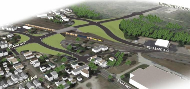
As of now, Grand Boulevard terminates at the CSX and Norfolk Southern tracks in Lindenwald. People walking, biking or driving must then head north along Central Avenue and then cut across the four railroad tracks diagonally.

This new project will extend Grand Boulevard to the west to University Boulevard, serving Vora Technology Park and Miami University Hamilton. Instead of crossing the four railroad tracks, the extended road will bridge them, thus offering fewer conflicts for pedestrians, cyclists and motorists, along with fewer restrictions for freight operators.

“SHX is very important for both safety and economic reasons,” said Smith. “With the recent announcement that Barclaycard is opening a 1,500 person facility at Vora Technology Park, the need for better access to the area is more important now than ever.”

Transportation officials say that 56 trains travel through this crossing on a daily basis, which results in its blockage a total of 15.3% of the time. As a result, the new overpass is expected to greatly improve connectivity, reduce travel times, and increase safety.

Project leaders say that construction should begin in March 2016 and be completed in mid-2018.