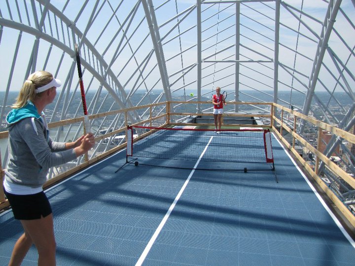
WTA players Melanie Oudin and Julia Boserup are in town this week for the Western & Southern Financial Group Women’s Open being held in Mason. Before the tournament got underway, the two engaged in a friendly tennis match atop Cincinnati’s newest skyscraper 630 feet above the street.
The Western & Southern Financial Group Women’s Open has grown in prestige recently and was upgraded to a “Premier 5” Women’s Tennis Association event joining tournaments in Dubai, Rome, Toronto/Montreal, and Tokyo. In 2011, the women’s tournament will merge with the long-standing Western & Southern Financial Group Masters men’s draw in an eight-day event. The combined tournaments will make the new Western & Southern Financial Group Masters & Women’s Open one of the top ten tournaments in the world, and the largest summer tennis tournament in the United States outside of the U.S. Open grand slam event.
The back-to-back 2010 tournaments currently taking place in Cincinnati are the first to take advantage of a new $10 million facility upgrade that includes an additional 890 stadium seats, six new luxury suites, major media facility upgrades, and player amenity improvements within the new 52,000 square-foot West Building. With the upgrades, the stadium’s 11,500 seat capacity makes it the 22nd largest tennis stadium in the world, and the seventh largest in the United States.
The Eastern Corridor project, a multi-modal highway and commuter rail plan for eastern Hamilton County, is back in the news. Two weeks ago Cincinnati City Council voted against endorsing a TIGER II grant application seeking funds for the plan’s 17-mile commuter rail component.
The local media predictably turned this event into another city-county dispute, and insinuated that the TIGER II grant might alone fund construction of the entire Milford commuter rail line, which in 2003 was estimated to cost $420 million. There is no possibility of this happening, as Milford commuter rail would need to be awarded approximately two-thirds of the entire $600 million sum to be dispersed nationwide by the TIGER II program.
The media also ignored the Eastern Corridor plan’s central feature – four miles of the Milford commuter rail line is planned to be built parallel to a new $500 million U.S. 32 expressway between Red Bank Road and a point east of Newtown. The 1990’s cost estimate for Milford commuter rail included the savings associated with building a combined highway and rail project, including a new shared eight-lane bridge over the Little Miami River. The cost of building the commuter line first without provision for the future highway has not been studied.
The Oasis Line
Between downtown Cincinnati and the proposed eight-lane bridge over the Little Miami River, the Milford commuter rail is planned to operate on an eight-mile stretch of track paralleling the Ohio River known as the “Oasis Line.” In the late 1980’s the L&N Bridge (now the Purple People Bridge) was closed to freight rail traffic, and thus ended the operation of large trains along the Oasis Line. Since that time, traffic has been limited to a handful of freight cars per week, and the Cincinnati Dinner Train on weekends.
At first glance it would appear that implementation of commuter rail service on the Oasis Line should require nothing more than the purchase of commuter trains and the construction of a connection between the end of active tracks and the Riverfront Transit Center. Unfortunately, the poor condition of the existing track limits traffic to a maximum twelve miles per hour, meaning all eight miles between the Montgomery Inn Boathouse and Red Bank Road must be rebuilt. It is also probable that the Riverfront Transit Center connection must be built at least partially through Bicentennial Commons at Sawyer Point. All of this new track must be heavy freight railroad track, not the smaller and less expensive track used by light rail trains and modern streetcars.
Even after this needed investment in new track, grade crossings will remain at a half-dozen locations along Riverside Drive and in Columbia Tusculum, where perfunctory horn blasts will disturb those residing in new condos along Riverside Drive, longtime residents atop Mt. Adams and East Walnut Hills, and will surely be audible across the river in Bellevue and Dayton.
Poor Station Locations
Residents of Riverside Drive will be able to hear the Milford commuter rail trains, but most will not live within easy walking distance of the line’s stations. Of five stations proposed along the Oasis Line, only one, Delta Avenue in historic Columbia Tusculum, can be considered auspicious. By contrast, little existing ridership or future development exists around either the proposed Theodore Berry Park or the Cincinnati Waterworks (downhill from Torrence Parkway) stations. Ridership at the proposed Lunken Airport station will be minimal, and the Beechmont Avenue station will primarily serve as a bus transfer point.
On top of this minimal ridership, Riverside Drive is already served by Metro’s #28 bus. If Milford commuter rail is built, this bus will still have to operate due to the infrequent service and long distances between stations along the Oasis Line. It is also likely that Metro’s #28X, which serves Mariemont and Terrace Park en route to Milford, will have to continue operations as well.
An alternative proposal that called for streetcar or light rail service between downtown and Lunken Airport could eliminate the need for the #28 bus route, thus freeing up resources for bus service elsewhere. In this scenario significant savings would be achieved due to the considerably lower track costs for streetcars and light rail when compared to the freight railroad track currently proposed for the Milford commuter rail. Additionally, the vehicles are much quieter because they are electrically powered, labor costs are halved because they require just one driver, and more stops could be placed at much closer intervals.
High Operations Costs
No funding source has been identified to cover the outrageous annual operating costs for Milford commuter rail. In 2004 its annual operations were estimated to be $18.9 million — a sum similar to the estimated annual operating cost of the proposed 250-mile 3C Corridor passenger rail service between Cincinnati, Columbus, and Cleveland.
The cause of these exorbitant operating costs is an alarming combination of mediocre ridership and high labor costs. A 2002 report projected approximately 6,000 weekday trips (3,000 commuters) along the Oasis Line at full build-out. For comparison, this ridership figure is roughly equivalent to Metro’s most popular bus routes. At the same time, the FTA requires a crew of two onboard all diesel commuter trains that operate on freight tracks, even for the small Diesel Multiple Units (DMUs) planned for the Eastern Corridor, due to safety regulations.
By comparison, the Cincinnati Streetcar as presently planned will cost approximately $128 million to construct, require $3 million per year to operate, and will attract similar or higher daily ridership with 15 fewer route miles of track. Last month, city officials were notified that the Cincinnati Streetcar was awarded a $25 million Urban Circulator grant. If an identical amount were hypothetically awarded to the Eastern Corridor project through TIGER II, it would cover so little of the much more expensive Milford commuter rail that no construction would even be able to take place. Meanwhile, an additional $25 million put towards the Cincinnati Streetcar could extend the line into Avondale or Walnut Hills immediately. This means a potential grant for the Milford commuter rail might sit in the county treasury for a decade or more, or through tricky accounting be integrated into the Eastern Corridor project’s highway funding.
The Wasson Line
An alternative rail route to eastern Hamilton County involves use of the Wasson Line, which joins the Oasis Line near Red Bank Road but travels a very different path between that point and downtown Cincinnati. This route is eight miles – the exact same distance as the Oasis Line – but promises much higher ridership and much lower operational costs.
Since all freight operations ceased on the Wasson Line in 2009, electric light rail vehicles staffed by a single driver can be used at considerable cost savings over diesel commuter trains needed on the Oasis Line. Proposed station locations at Xavier University, Montgomery Road, Edwards Road, and Paxton Avenue each promise higher initial ridership — in 2002 the Wasson Line was estimated to attract 20,000 daily riders, or triple that of Milford commuter rail.
Also different from the Oasis Line, redevelopment potential exists around all of the stations locations along the Wasson Line, but especially the 25-acre parallelogram-shaped parcel recently assembled by Xavier University between its campus and Montgomery Road. The abandoned Wasson Road Railroad bisects this property and converges with the similarly abandoned CL&N railroad at the present edge of Xavier’s campus. The particular junction played a major role in the 2002 MetroMoves regional rail plan due to the convergence of several regional lines on their way into downtown along shared Gilbert Avenue tracks.
The Edward Road station is another location superior to anything on the Oasis Line. It is located within walking distance of Hyde Park Square and the majority of the neighborhood’s population. The station would be placed adjacent to, or across the street from, Rookwood Commons shopping center, and just a three-minute walk from the undeveloped Rookwood Exchange site north of Edmondson Road.
The Wasson Line has decisive cost-benefit advantages over the Oasis Line, but it obviously cannot function without a connection between Xavier University and downtown. After completion of the Cincinnati Streetcar, construction of a light rail connection between these points should be a top priority. This section alone promises the highest per-mile transit ridership in the metro area, and reaching Xavier University allows construction of three light rail branches, on existing railroad right-of-way, as funds permit.
Regional Priorities
It is unclear why construction of the Eastern Corridor project is any kind of priority. Much of the expense will be borne by Hamilton County, but with parts of the highway and rail line traveling over the undevelopable Little Miami River flood plain, the new expressway and perhaps even the rail line will act to encourage sprawl in Clermont County. Even the terminal station for the Milford commuter rail will not be in Milford’s town center, where it would be within walking distance of several hundred residents, but rather two miles away at Milford Parkway, home to Wal-Mart, Target, and chain sports bars.
Anti-rail forces are fond of saying that rail advocates will support anything that runs on rails. But advocates of better public transportation know that funds for rail projects are scarce and must be applied where the best cost-benefit exists. Moreover, the best transit mode must be chosen for each route. In the case of inner-city rail to Cincinnati’s eastern suburbs, diesel commuter rail along the Oasis Line is not the best solution, but rather, light rail service along the Wasson Line is.
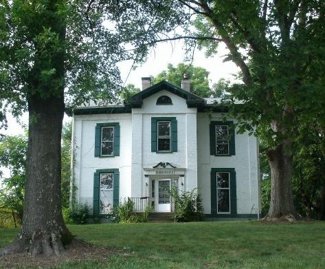
The Cincinnati Preservation Association (CPA) announced that a 145-year-old home in College Hill will be sold at an online auction between August 11-17.
According to CPA, the two-and-a-half story structure was completed in 1865, and boasts Greek Revival pilasters and Gothic Revival gables. The Hamilton County Auditor reports that the home has 2,800 completed square feet, and sits on nearly a half-acre of land in College Hill that is within walking distance of the neighborhood’s business district.
Currently owned by the U.S. Marshals Service, 1314 Groesbeck Road will have a nominal opening bid of $1,000. The auction will be held online only, and all bids must be made by 9:10am on Tuesday, August 17. Those interested in bidding are asked to visit the auction website being hosted by Williams & Williams Auction Services.
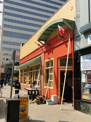
The wait is finally over, as the much anticipated Jean-Robert’s Table will open in downtown Cincinnati for dinner on Tuesday, August 10 at 5:30pm.
Unanticipated construction delays, and personal reasons pushed back the original opening of Jean-Robert’s Table for the famed Cincinnati chef. The new restaurant is Jean-Robert de Cavel’s first since parting ways with long-time restaurant partners Martin and Marilyn Wade which included endeavors like Pigall’s, JeanRo Bistro, Lavomatic, Chalk Food + Wine, and Greenup Cafe.
Since the break up, Jean-Robert de Cavel has moved on to become the chef in residence for the Midwest Culinary Institute, while also developing the concept for the new restaurant opening on Vine Street tomorrow.
“I have watched the dining public’s habits change during the last 24 months, and I have taken time to create a menu and an atmosphere that speak directly to what the dining public wants,” Jean-Robert said is a prepared release. “The people of Greater Cincinnati will see this is not Pigall’s and it is not JeanRo Bistro, but a hybrid of the two which will serve a broad range of items from specialty sandwiches to frog legs and escargot.”
Jean-Robert also says that diners will be able to enjoy a great wine list that offers reasonably priced wines, while also featuring some of the “Fantastic Years” for those looking to enjoy boutique wines.
Inside the refurbished restaurant space that once house Buddakhan and Longhorn Steakhouse, Jean-Robert’s Table will seat 115 people between the dining and bar areas. Beyond the interior modifications, the beloved French chef is excited about the restaurant’s location in the heart of downtown Cincinnati.
“I chose 713 Vine Street due to its centralized location one-and-a-half blocks from city center, that makes it easy access for both lunch and dinner. The location also has excellent parking adjacent to the restaurant which makes it easier for diners to park within steps of the front door,” Jean-Robert described.
So far the location and Jean-Robert combination seems to be paying off as the restaurant is already booked solid for its first night of dinner service, with an additional 120 people on a waiting list for Tuesday night’s opening. Reservations are being accepted for the rest of the week’s “soft opening”. As a result, a limited number of seats will be available, and lunch service will not begin for another two weeks.
Dinner service will be offered Monday through Thursday from 5:30pm to 10:30pm (bar open until 1am), and Friday through Saturday 5:30pm to 11pm (bar open until 2am). Once lunch service begins, it will be offered Monday through Friday from 11:30am to 2pm. Reservations can be made by calling (513) 621-4777 daily between the hours of 10am and 5pm.
“My staff and I are excited and looking forward to being back on the firing line! We cannot wait to see all of our friends who have supported us so kindly during the last 18 months. Jean-Robert’s Table is my attempt to support my adopted city, my adopted friends and give back in a way that I love to do, through cooking!”
The new restaurant is expected to employ around 30 full- and part-time employees. Those interested can stay connected through the Facebook page for Jean-Robert’s Table or by following the restaurant on Twitter @jrtable.
I am a native of the Greater Cincinnati area, but I have spent the better part of my adult life living and working in Chicago. I left Chicago in 2007 for greener pastures in New York City, and then ultimately found my way back home to Cincinnati earlier this year. However, I still look back on my time in Chicago as having an enormous impact on my thoughts about urban planning and design, architecture, and mass transit.
In June of this year, and after a long absence, I spent my first weekend in Chicago since becoming involved in discussions about Cincinnati’s ongoing urban renaissance. Once I arrived in town, I could not help but look at my old stomping grounds in a whole new light, and see Chicago’s urban development through the eyes of a born-again Cincinnatian. Over the course of a few days, I was able to explore a few key differences between the two cities, and perhaps come home with a few insights that can be applied to Cincinnati.
Urban Form:
The first and most obvious difference between Cincinnati and Chicago is one of sheer scale. While driving through Indiana on the way to Chicago from Cincinnati, the transition from rural cornfields to suburban sprawl (and its inevitable traffic jams) began while I was still a good 40 miles away from the Chicago Loop. Here in Cincinnati, 40 miles in any direction from Fountain Square would be considered far into the hinterland. Indeed, it is possible to find oneself in a relatively rural area in less than five miles from downtown Cincinnati, depending on the direction of travel.
Topography plays a large role, of course: the Cincinnati area’s steep hills prevent large-scale development in many areas, while the vast plains surrounding Chicago offer no such limitations. I see this as an advantage in Cincinnati’s favor: In addition to providing unique vistas and hillside neighborhoods that Chicagoans could only dream about, Cincinnati’s geographic setting allows for an easy escape to the country without having to drive through 40 miles of strip malls and traffic congestion (assuming one isn’t trying to escape via I-75 or I-71).
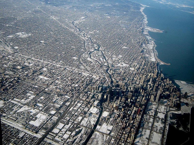
Chicago’s scale is apparent when flying into either of the city’s two airports, especially at night. Chicago’s relentless street grid stretches from horizon to horizon, with the radial streets and freeways all leading to the mountain of skyscrapers downtown. The city’s magnificent lakefront parks form an elegant transition from dense urban neighborhoods to the empty expanse of Lake Michigan. The entire city — so orderly and logical from above, like a circuit board — has the appearance of a vast machine. Down on the surface, though, the machine-like efficiency of the street grid leaves little room for quirks and eccentricities such as Cincinnati’s Mt. Lookout Square or O’Bryonville.
Commercial Districts:
Aaron Renn recently wrote a thought-provoking article about how cities treat their ordinary spaces versus their special spaces, and I believe Cincinnati has the edge in this regard. We don’t have the “special spaces” that Chicago has, such as a Magnificent Mile or a Grant Park (although that is changing for the better as Cincinnati develops its riverfront), but we have a vast number of unique “ordinary spaces” that each have their own character. For example, Chicago’s neighborhood business districts tend to be linear corridors along straight commercial streets, with relatively little distinction from each other. Aside from the makeup of the retail establishments, the urban space of Broadway in Lakeview isn’t much different from that of Milwaukee Avenue in Wicker Park or of Lawrence Avenue in Albany Park. Here in Cincinnati, even if you disregard the types of businesses that occupy the storefronts, there is a real difference between neighborhood business districts such as Ludlow Avenue, Hyde Park Square, and Over-the-Rhine.
Speaking of Over-the-Rhine, there is simply nothing like it in Chicago, as OTR was a bustling urban neighborhood when Chicago was still a remote trading post. Chicago’s present form didn’t come into being until after the Great Chicago Fire, by which time many buildings in Over-the-Rhine were already a generation old. For an urban neighborhood that comes close to resembling Over-the-Rhine, one must look east to New York or Philadelphia rather than west to Chicago.
Residential Neighborhoods:
If Chicago’s commercial avenues are rather drab, that city’s residential side streets offer many lessons for Cincinnati. Upon taking a turn down a leafy side street in Chicago, a pedestrian immediately enters a lush, green world where the noise of the city fades away and the harshness of the sunlight is filtered out by a dense canopy of trees, usually flanked by ornate row houses, bungalows, or apartment buildings. The importance of greenery cannot be understated, and as Over-the-Rhine continues its rejuvenation, Chicago shows that when it comes to street trees, there’s really no such thing as too many. It’s no coincidence that OTR’s Orchard Street — arguably the greenest street in the neighborhood — is also one of the most sought-after streets for renters and homebuyers.
Cincinnati’s dominant grocery store chain could also learn a thing or two from Chicago’s two largest chains on how to design and operate “big box” grocery stores that add life to urban business districts, rather than suck life from them. Throughout Chicago’s denser neighborhoods, Dominick’s (a division of Safeway) and Jewel (a division of Albertson’s) are building stores that place the main entrance at the corner of the building, facing a busy intersection, rather than behind an ocean of parking. In many cases, the stores are multi-story affairs with residential or commercial space above, and parking in a garage tucked around the corner.
An urban-scaled Dominick’s Store in Lincoln Park
One of the first such stores is a Dominick’s location at the corner of Fullerton and Sheffield, adjacent to a CTA rapid transit station and DePaul University. The ground floor of the store contains a deli, butcher and seafood department, florist, bakery, a Starbucks, and the checkout lanes, while the second floor contains aisles of groceries and general merchandise. Large-capacity elevators allow customers to transport strollers and shopping carts between the floors.
Up in my old neighborhood of Edgewater, a Dominick’s store at the corner of Foster and Sheridan — an older suburban-style store not unlike the Kroger store in Corryville — is being replaced with a modern store that respects the neighborhood rather than turning its back on it. If Kroger’s two largest national competitors, Safeway and Albertson’s, are tripping over each other to build urban-scaled grocery stores in dense neighborhoods, then Kroger’s claim that there is no market for such stores would seem to ring hollow.
Public Transit:
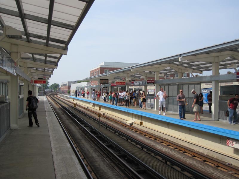
Another key difference between Cincinnati and Chicago that cannot be ignored is public transit. While Chicago’s system of public transit is not perfect by any stretch, Chicago has a culture in which taking a train to work or for shopping is simply accepted as a routine fact of life for most people, rather than as something that is done only because one has no other choice. There is no stigma, and a wide variety of demographic groups can be found represented on the city’s buses and trains on any given day. Regrettably, only a handful of American cities have achieved this, and Cincinnati is not yet one of them. To its credit, the Chicago Transit Authority has recently completed an ambitious upgrade of many stations on the city’s north side and west side, with further upgrades elsewhere in the city underway.
The newly-renovated CTA rapid transit station in Lincoln Park
Finally, and perhaps most importantly, is the difference in general attitude between the two cities. Chicago has a certain swagger that Cincinnati lacks, a confidence among the populace that the city is capable of doing great things and attracting great people. This is a double-edged sword, in that Chicago’s reputation of being “the city that works” involves a strong-man mayor who has almost unlimited powers, who can easily crush any community opposition to his plans.
Indeed, while certain Chicago neighborhoods are high-priced hotbeds for economic development, vast parts of the city continue to look as if they were imported from Detroit. There is also the corruption: In Cincinnati, it would be almost unthinkable for a City Council member or department head to be hauled away in handcuffs by the FBI and indicted on federal corruption charges. In Chicago, such occurrences happen often enough that they barely even make the local news.
Cincinnati, on the other hand, has a long-standing inferiority complex that has proven difficult to shake. But as major projects such as the streetcar, The Banks, and Central Riverfront Park are completed, perhaps Cincinnati will adopt a unique swagger of its own, while avoiding some of the pitfalls of our younger and larger neighbor to the north.