[This op-ed was originally published on The Urbanophile on July 13, 2010. Visit the original op-ed for more comments, thoughts and opinions on the matter of Cincinnati’s dramatic riverfront revitalization effort over the past two decades – Randy.]
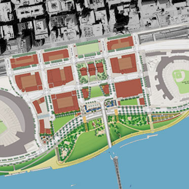
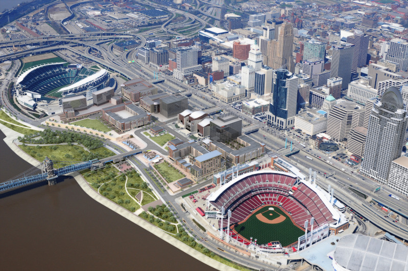
Several decades ago Cincinnati leaders embarked on a plan to dramatically change the face of the city’s central riverfront. Aging industrial uses and a congested series of highway ramps was to be replaced by two new professional sports venues, six new city blocks of mixed-use development, a new museum, a central riverfront park, and parking garages that would lift the development out of the Ohio River’s 100-year flood plain.
Paul Brown Stadium, home of the Cincinnati Bengals, was one of the first pieces of the puzzle to fall into place. The $455 million football stadium kept the Bengals in Cincinnati and has received national praise for its architectural design while also entertaining sold-out crowds.
The next piece to fall into place was the reconstruction of Fort Washington Way which consolidated the stretch of highway and opened up land critical for the construction of yet another stadium and the mixed-use development which became known as The Banks. The 40% reduction in size was not the only accomplishment though. The reconstruction project also included the Riverfront Transit Center designed to one day house light rail connections and a sunken highway that could be capped with additional development or park space.


Following the reconstruction of Fort Washington Way, Riverfront Stadium was then partially demolished to make room for the construction of the $290 million Great American Ball Park. Once complete, Great American Ball Park began entertaining baseball fans at 81 home games each year and at a new Reds Hall of Fame & Museum. The new venue eliminated any need for Riverfront Stadium and thus led to its implosion in 2002.
The removal of Riverfront Stadium then freed up room for the construction of the National Underground Railroad Freedom Center atop the first piece of a two-deck parking garage intended to both lift the new riverfront development out of the flood plain, and provide enough automobile parking to replace what was previously there in the form of surface lots and satisfy new parking demands created by the development.
The most recent piece of the puzzle has been the development of the initial phases of both the Cincinnati Riverfront Park and The Banks. The two separate projects are developing in complimentary fashion and are on similar time tables, and are both developing east to west from Great American Ball Park to Paul Brown Stadium. Recent news will add a modern streetcar line running through The Banks development that will transport people from the transformed riverfront into the Central Business District, Over-the-Rhine and beyond to Uptown.


The 45-acre, $120 million Cincinnati Riverfront Park is expected to become the crown jewel of an already nationally acclaimed Cincinnati Park System. The Banks meanwhile will bring thousands of new residents, workers and visitors to Cincinnati’s center city. The initial phase of both projects is expected to be complete in spring 2011 and will include 300 new residences, 80,000 square feet of retail space, Moerlein Lager House, Commuter Bike Facility, additional components of the two-deck parking garage, and the first elements of the park.
The transformation of Cincinnati’s central riverfront from aging industrial space to a vibrant mixed-use extension of downtown is not complete, but the two-decade old, $3 billion vision is finally nearing reality. And with full completion expected in the coming years, one of the remaining traces of Cincinnati’s industrial past will be replaced by a new vision for a 21st Century city and economy.