Categories
Business Development News Opinion Transportation

Cincinnati’s Wasson Railroad Corridor Should Not Be Converted Into Recreational Trail

In the post-industrial United States cities all across America have been left with an abundance of rail right-of-way that once served industrial properties. Cities have since struggled to find a use for these rail corridors.

In many cases the rail right-of-way either gets built over, or makes room for some other use – most typically a park or trail of some sort. The most famous, and perhaps most unique, example of this is New York City’s Highline which converted an abandoned freight rail corridor into an elevated park. In most cities, however, much simpler trails are developed in order to cater to bicyclists and pedestrians.

These are great projects, but in the cases where rail right-of-way is needed in order to introduce rail transit, they should not be done. The acquisition of right-of-way can be one of the most difficult hurdles to clear when developing rail transit, so if you have a prime corridor intact, you should do everything in your power to preserve it for future rail transit.


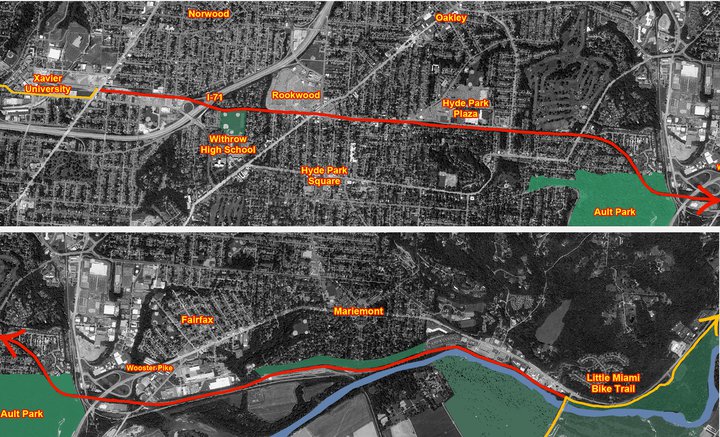
Map of the proposed Wasson Way Project.

The reason this is particularly important in Cincinnati right now is because on March 6, advocates of what is being called Wasson Way Project will present their ideas for converting the Wasson Corridor into a bike/ped trail to City Council’s Strategic Growth Committee.

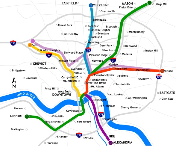
The idea is not a bad one on face value, but should it proceed it would eliminate one of the most valuable rail corridors in the city. A corridor that could connect neighborhoods like Hyde Park, Oakley, Evanston, Norwood, Mt. Lookout, Fairfax and Mariemont with light rail and eventually connect those neighborhoods to the region’s two largest employment centers – uptown and downtown – without much additional track or right-of-way acquisition.

“I know of no example in the United States where a former railway that has been converted to a bike/hike trail has ever been returned to passenger rail service,” explained Cincinnati transit advocate John Schneider (aka “Mr. Transit”). “Once it’s gone, it’s gone.”

Rail corridors that run through areas of limited potential transit ridership like the Oasis Line should be redeveloped into trails. It just makes sense. There is less automobile traffic and the riverfront trail provides a scenic ride for bicyclists and connects its users to a string of riverfront parks.

The Wasson Line, however, is ripe for light rail service with its densely populated neighborhood, vibrant business districts and key attractions along the line. The Oasis Line should become a bike/ped trail, but the Wasson Line should not.

Unfortunately the exact opposite is progressing for both of these lines in Cincinnati. Hamilton County officials continue to explore funding options to turn the Oasis Line into a commuter rail corridor, and a citizen-led group is strongly advocating for the conversion of the Wasson Line into a bike/ped trail.

While UrbanCincy supports conversion of some rail right-of-ways into other uses, we believe it needs to be done in a thoughtful manner that considers the future transit needs of the region. The Wasson Line is too valuable to convert into a bike/ped trail and should be preserved for an urban light rail line.

The upcoming committee meeting is scheduled to take place at 12pm on Tuesday, March 6 at City Hall (map). We would like to urge you to come out and support the future of regional light rail in the Cincinnati region, and request that the Wasson Corridor not be converted into a recreational trail.

Categories
Business Development News Politics Transportation

The story behind Cincinnati’s slowly disappearing skywalk system

Over the past few weeks, city crews were busy dismantling another section of downtown Cincinnati’s once extensive skywalk system. The section, an open air walkway over Elm Street and Rusconi Place, was taken down by the city in preparation for the World Choir Games this summer, and the demolition is the latest phase of an ongoing effort to dismantle the city’s once expansive skywalk system.

Developed in the 1960’s as a way for downtown retailers to compete with the enclosed shopping environments found in suburban malls, the city implemented an ambitious plan to construct a series of elevated walkways extending from Fourth and Broadway northwest to the Duke Energy Convention Center.

The skywalks became the preferred connection to places along the route including Fountain Square; Tower Place Mall; department stores such as Shilito’s, Pogue’s, McAlpin’s and LS Ayers; as well as corporate office buildings; Riverfront Stadium; the convention center and its adjoining parking garages.

By the early 2000’s, the skywalk system was stymied by poor way-finding and aggressive pan-handling, and several sections had fallen into disrepair. The system was difficult to control and maintain due to ownership issues surrounding the elevated walkways. But to many urban planners, the biggest issue was that the skywalk system discouraged street-level foot traffic.

Removal and reconfiguration of the skywalk system was proposed as part of the 2002 Center City Plan. The plan found that downtown Cincinnati was declining due to loss of economic activity to the city’s suburbs, and it emphasized the development of places in downtown that highlighted the urban core’s built assets.

Skywalks, the report said, allowed pedestrians to bypass the street which contributed to the perception that downtown was abandoned. To counter those perceptions, the report called for expanding street-level pedestrian activity while also programming pedestrian activity on the street to create economic vibrancy.

“The way you help to build a vital center is to put people on the streets and to enable them to have connectivity on these streets,” city spokesperson Meg Olberding told UrbanCincy.

The city’s actions were even profiled by the New York Times in a 2005 story entitled Rethinking Skyways and Tunnels.

“And now, as cities try to draw residents downtown with loft conversions and tax incentives, several are trying to divert pedestrians back to the street and do away with the walkways.” Patrick O’Gilfoil Healy wrote. “Critics say the walkways are too antiseptic and too controlled and have transformed cities into places to pass through, not live in.”

The skywalk began to come down with the reconfiguration of Fort Washington Way. A piece connecting Riverfront Stadium to the Atrium I and II office towers was demolished in 2002, with other pieces following thereafter. In 2005, the city demolished two sections of the skywalk from the 5/3 Tower to Vine Street and the pedestrian bridge over Fifth Street as part of the $49 million redevelopment of Fountain Square. A second segment that connected Saks Fifth Avenue to the site of a former office tower at Fifth and Race was then dismantled in 2007, and other older sections of the skywalk are likely to be removed in the near future.

Although a considerable amount of the system is still intact today, the biggest improvement from the dismantling thus far can be seen at Fountain Square. Prior to its removal, the Vine Street Skywalk was the busiest skywalk in the city carrying thousands of pedestrians over many street level storefronts and street vendors. The removal of this skywalk helped create today’s vibrant Fountains Square, which is a testament to this policy shift.

As for future plans for the remaining segments of the skywalk, City officials have informed UrbanCincy that the skywalk connecting to Macy’s over Race Street will likely not be utilized in the upcoming dunnhumbyUSA development at Fifth and Race. Oldberding also disclosed that future skywalk demolitions will be decided on a case-by-case basis saying, “We look at how they are contributing to the vitality of the urban center.”

As the skywalk is slowly removed, we have found it necessary to chronicle the once enormous reach of the declining system. UrbanCincy’s research team has developed a map charting the demolished and remaining sections of the skywalk system, as well as the one possible expansion at Great American Tower at Queen City Square. As new sections come down, the map will be updated to reflect those changes.

Categories
Business Development News Politics Transportation

Hundreds of Cincinnatians celebrate groundbreaking of Midwest’s first modern streetcar

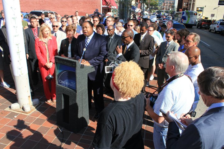
On what turned out to be virtually perfect weather for Cincinnati in mid-February, hundreds of people gathered to celebrate the official groundbreaking of the Cincinnati Streetcar this past Friday.

The event was announced to the public a week prior, and included dignitaries and media from not only Cincinnati but from around the United States. The #LetsGo stream used on Twitter quickly became a trending topic and people from St. Louis, Portland, Washington D.C., Atlanta, Chicago, Milwaukee, Seattle, Cleveland and Indianapolis chimed in with their praise of Cincinnati.

Some of the dignitaries at the event included FTA Administrator Peter Rogoff; Cincinnati Mayor Mark Mallory (D); City Manager Milton Dohoney; councilmembers Laure Quinlivan (D), Roxanne Qualls (C), Chris Seelbach (D), Yvette Simpson (D), Wendal Young (D), Cecil Thomas (D); and Secretary of Trasnportation Ray LaHood (R).

Those in Cincinnati who have been involved with its efforts to improve its transit system know that the most honored guest of the day was John Schneider. Schneider, or as Mayor Mallory refered to him “Mr. Streetcar,” has been advocating regional transit improvements for nearly two decades and has taken scores of Cincinnatians to Portland to see how modern streetcars work first-hand.

Schneider also serves on the Cincinnati Planning Commission and has been living car-free in Cincinnati for many years. During the press conference Mayor Mallory gave the podium over to Mr. Schneider so that he could share his thoughts on the historic day.

UrbanCincy contributor Jake Mecklenborg also captured the climatic end to the event as the hundreds in attendance counted down to the official groundbreaking.

Categories
Arts & Entertainment Business Development News

A revitalized Washington Park intends to serve as historical, cultural bridge

This Friday hundreds of people will gather at Memorial Hall to celebrate the groundbreaking of the Cincinnati Streetcar. Appropriately so, the event will take place in the city’s oldest neighborhood and right outside of Washington Park which has long served as a prominent landmark within the region’s urban core.

Cincinnati is changing, and as a city with a prominent history, Cincinnati is working to reconnect with its past during this process. But the people are not the same as they were in the past. There are new faces and a new culture.

At the center of this change is the redevelopment of Over-the-Rhine. From the remodeling of Italianate brownstones to the renovation of Music Hall this change can be seen everywhere. However, no change has been as significant, both in scale and in reconnecting with the significance of the past as the $48 million renovation of Washington Park.


Cincinnati’s majestic Music Hall overlooks Washington Park. Photograph by Randy A. Simes for UrbanCincy.

In 1888, Washington Park hosted the Centennial Exposition of the Ohio Valley and Central States. With the newly created Music Hall illustriously lining Elm Street, Washington Park, only 33 years old at the time, showcased progress the Northwest Territory and city of Cincinnati had made in a century’s time. The exposition presented the urban development of a thriving city, and the economic and social progress of the United States, to the rest of the nation.

It has been a long time since 1888, and in 2010 the Cincinnati Center City Development Corporation (3CDC) began upgrading Washington Park to meet the needs of a changing urban core. The park’s historical significance has been on the mind of the developers since the very beginning.

“Everything we do is greatly influenced by history,” 3CDC Vice President of Communication, Anastasia Mileham, told UrbanCincy. From Civil War cannons to head plaques from the Presbyterian cemetery that once occupied the site; the renovated park will be filled with artifacts and reminders of the past.

Project officials say that the changes taking place at Washington Park are about more than just nostalgia, however, and will serve to help advance the urban revitalization taking place in Over-the-Rhine.


Construction work progresses at Washington Park in November 2011. Photograph by Randy A. Simes for UrbanCincy.

“This will be a great civic space similar to Fountain Square,” Mileham explained. “Once finished, the park will have the potential to be the heart of the community as it once was.”

The people who make up Cincinnati have also changed greatly over the past 124 years. Today Over-the-Rhine is the definition of a multigenerational and multiethnic district. With a two-acre expansion, an underground parking garage, an interactive water fountain, and a grand performance stage, the new Washington Park will seemingly be a place for individuals and families alike – a reflection of the changing neighborhood.

“If you want to stroll through the park, walk your dog in the fenced in dog park, or listen to the CSO perform on a Sunday evening, then Washington Park is for you,” Mileham said, “It has features for everyone, and will make a mixed neighborhood in every sense of the word.”

As Cincinnati changes, so too does our understanding of its history. Washington Park is in part a monument to the past. It is a monument to what Cincinnati once was. But as the city takes on new shapes and sizes, and becomes increasingly diversified, Washington Park will also serve as a bridge. A cultural connection and a monument to what Cincinnati has become.

Categories
Business Development News Politics Transportation

Cincinnati to break ground on streetcar project next week with Ray LaHood

Councilmembers Christopher Smitherman (I) and Charlie Winburn (R) called a special city council hearing today to discuss the finances of the $110 million Cincinnati Streetcar project. The hearing had a specific focus on utility relocation agreements due to the current impasse between the City and Duke Energy.

City officials stated unequivocally that the project will move forward, and that it is common for projects of this scale to have ongoing issues needing to be resolved even once ground has been broken. Both Mayor Mark Mallory and City Manager Milton Dohoney stated that an agreement will eventually be made with Duke Energy, but that the engineering disagreements between the two parties needs to be resolved first.


Rendering of the streetcar along Walnut Street in downtown Cincinnati.

The biggest question at hand, with Duke Energy, is that the City has looked at existing streetcar projects around the United States and come up with a standoff they believe is workable. Duke Energy, meanwhile, has disagreed with those statements and believes that a much greater standoff is needed.

Duke Energy estimates that the relocation work, based on their engineering, would cost approximately $18 million. The City, on the other hand, believes it should only cost $6 million based on the work of their engineers.

“Utilities are issues in every transportation project, not just rail but roadway projects as well,” a representative from Parsons Brinckerhoff told UrbanCincy immediately following the meeting. “This is true for every single project, and they get worked out, and moved forward.”

At a press conference held earlier this week, City Manager Dohoney stated that City of Cincinnati should not be responsible for subsidizing the modernization of Duke Energy’s utility assets, and that the two parties will remain at an impasse until the engineering is validated.

The big news came in the final statement of the meeting when Mayor Mallory announced the groundbreaking for the Cincinnati Streetcar will take place at 1pm on Friday, February 17 outside of Memorial Hall (map). Mayor Mallory also stated that city and project officials will be joined by the Secretary of Transportation Ray LaHood at the groundbreaking.

Jenny Kessler and John Yung contributed to this story.