Categories
News Transportation

How to Reimagine Our Streets Around the Concept of Shared Space

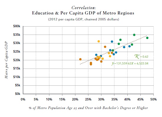
CNU22 featured speakers from all over the world, from Bogotá to Toronto to Brighton. One plenary speaker from Bristol moved the audience with an idea called Shared Space that was beautifully simple and innovative, yet entirely new to most of the crowd.

Ben Hamilton-Baillie is a British urban designer, “recovering” architect and self-taught in the area of transportation planning. His presentation focused on explaining Shared Space as an urban design technique that can alleviate the frequently problematic interface between pedestrians, cyclists, automobiles and the public realm.

As the name would suggest, Shared Space advances the idea that streets themselves can be a seamless part of public space that is shared by all users. The method came from the Netherlands, where Hamilton-Baillie studied under transportation engineer Hans Monderman and Joost Váhl, who developed the Dutch woonerfs where pedestrians and cyclists have priority on roadways.

The concept also integrates a thoughtful assessment of human psychology as it relates to driving. “It’s essential to understand the changing view of the nature of risk,” Hamilton-Baillie explained. “Hazards keep us aware of our environment and allow us to adapt our behavior.”

This seems counter-intuitive, but it was effectively explained through an example of two cities in the Tel Aviv region of Israel.

Bnei-Brak, located east of Tel Aviv, is composed of largely low-income, ultra-conservative Jews. Ramat-Gan, also located east of Tel Aviv, is home to a more moderate, middle-income Jewish population. Hamilton-Baillie explained that the people of Bnei-Brak are known throughout the region as being unruly pedestrians. Adults and children cross streets with disregard for traffic. Locals know that they must be vigilant when driving there.

Conversely, the residents of Ramat-Gan respect pedestrian rules, crosswalks, and jaywalk less frequently. Drivers are more at ease in Ramat-Gan.

Perhaps counter-intuitively, there is a higher instance of pedestrian fatality in Ramat-Gan. Drivers in Bnei-Brak tend to cautiously drive at lower speeds, aware that there is a greater risk of a pedestrian appearing in the road. One can see in this example that increased risk makes for more attentive drivers.

Shared Space utilizes risk in the form of mixing cyclists, pedestrians and motorists on streets, and relies on the idea that removing lines and signaling allows for social protocols to take over more strongly than signs. This, Hamilton-Baillie said, is called “friction”, or natural cues that guide a driver’s speed. There is already an increasing awareness in North America that things like narrow streets, street trees and buildings built to the right-of-way naturally induce drivers to reduce speed without a speed-limit.

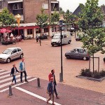
One might think that this friction would create delays, but evidence from project implementation has found the opposite, as did Hans Monderman’s projects in the Netherlands. And post-project evaluations, like in Poynton, UK, have confirmed the efficacy of Shared Space designs.

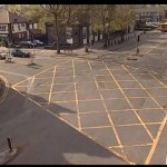
Poynton is a city southeast of Manchester. It is a throughway for traffic between the two larger cities of Macclesfield and Stockport. In this instance, vehicles were found to be passing on the main thoroughfare at a rate of 26,000 per day, many of which were trucks. The initial approach to relieve congestion was the construction of additional lanes of traffic.

Shared Space, however, was applied as part of a regeneration scheme in Poynton. The first task for Hamilton-Baillie’s consultancy was to “remove every trace of traffic engineering.”

Three lanes of cars were reduced to one, signaling was removed, additional on-street parking was introduced, and sidewalks were widened. There was increased edge friction through vertical elements within the driver’s line of vision.

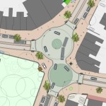
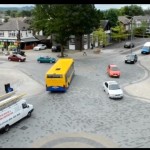
Even after the removal of two lanes and signals, traffic flow stayed the same and pedestrian traffic increased five-fold. Before the project, 16 of 32 shops in town were boarded up; but within one to two years after project completion, all shop spaces in the business district were occupied.

Streets were able to concurrently be part of Poynton public space and serve through traffic – the change in aesthetics was remarkable.

It is certain that freight and car movement is critical to the healthy functioning of any economy. This fact is not contested. But since civilizations started building cities, they have been venues for people to roam – sometimes at odds with our economic necessity to move people and goods through them quickly.

Fast big things and slow small things do not mix well.

Shared Space demonstrates that these seemingly incompatible users actually function better when mixed within the city fabric – cars move more fluidly when drivers are forced to react to their surroundings instead of their actions being dictated to them. People are safer, too.

The outcome is that streets become a different kind of public space, where mobility means interacting with one’s surroundings.

When asked if he thought famously impatient North American drivers could adapt to the concept, he paused for a moment and said, “Everywhere Shared Space has been applied, I was told that the drivers in the locale couldn’t adapt. In every case they did.”

Categories
Arts & Entertainment News

‘Pride on Main’ Will Set the Stage for this Month’s Second Sunday on Main Festival

Second Sunday on Main (SSOM) returns to the streets of Over-the-Rhine this Sunday, from 12pm to 5pm, after drawing a record attendance and number of vendors for its first festival of the season last month.

As is the case with all SSOM events, this one will once again feature dozens of local arts and crafts vendors, local food and beer, live music, food trucks, street performers and more.

The event is free and open to the public, so even if you don’t have a bunch of cash to drop, you can swing through for a leisurely stroll and people watch in what is Cincinnati’s oldest and most prominent Open Streets events.

Each month event organizers change up the theme for SSOM; and this month’s event is called Pride on Main. To complement the theme there will be the Missed OTR Drag Queen Contest and the famous Drag and Tryke Races, both of which will have their proceeds go to benefit Pride 2015.

This is the ninth year the OTR Chamber of Commerce has put on Second Sunday on Main. For those who haven’t attended in the past, the event stretches from Thirteenth Street to Liberty Street along, you guessed it, Main Street. There are also small segments of side streets that are closed off and include some additional activities.

There will also be a cooking demo by Chef Jose Salazar and speciality cocktail demo by bartenders Andrew Rettig and Steven Clement at 2pm inside Mr. Pitiful’s. Throughout the day, Art on the Streets will also be working on a crosswalk painting project at Main and Liberty Streets.

A full schedule and list of music performers and other details can be found on SSOM’s website.

EDITORIAL NOTE: UrbanCincy is an official media partner of Second Sunday on Main; and is proud to support the city’s oldest open streets festival.

Categories
Business News

REPORT: Cincinnati Region Failing at Developing Walkable Urban Places

U.S. Metropolitan Land Use OptionsA recently released report conducted by The George Washington University’s Center for Real Estate & Urban Analysis in conjunction with LOCUS: Responsible Real Estate Developers and Investors, a coalition of Smart Growth America gave the Cincinnati region low marks for its walkability and growth patterns overall.

The report, entitled Foot Traffic Ahead, attempts to quantify the seemingly surging movement of people back into cities with a desire for walkable places.

The idea is that developers, investors, government regulators and financiers understood the model that successfully built America’s suburbs during the second half of the 20th century, but that a new model is needed with that era now behind us.

“Over the next generation, walkable urban development will spur even greater economic growth as demand for walkable urban development is met. The future growth of walkable urban places could provide the same economic base in the 21st century that drivable sub-urbanism did in the mid- to late-20th century. However, this growth will not be realized without appropriate infrastructure, zoning, and financing mechanisms at the federal, state, and local levels.”

Therefore, the authors of the report, in coordination with a Brookings Institution methodology developed in 2012, defined two primary forms of land use: drivable sub-urban and walkable urban. They also defined the two primary economic functions of those forms as being either regionally significant or local-serving.

Of the four potential combinations of these forms and functions, Foot Traffic Ahead focused on the regionally significant walkable urban places (WalkUPs) in each of the nation’s 30 largest metropolitan regions. When considering all of this, the authors of the report identified 558 WalkUPs nationwide, with 66 of those located in the New York City metropolitan area alone.

Out of the 30 regions studied, Cincinnati was ranked 20th with seven total WalkUPs in the region. Those seven WalkUPs, the report found, contained 33,234,000 square feet of office and retail space, or approximately 15% of the region’s total.

When compared with other regions, an astonishing 100% of the office and retail space located within WalkUPs were within the central city. What this means is that while Cincinnati’s urban core is extremely walkable, virtually nothing outside of it is. As a result, Cincinnati fell at the low end of the six regions classified as ‘Tentative Walkable Urbanism’.

“Four of these six metros – Houston, Columbus, Kansas City and Cincinnati – have 93% or more of their walkable urban office and retail space in the central city; virtually no walkable urbanism exists in their suburbs,” the report noted. “These four metros continued the expansion of drivable sub-urban development patterns.”

It is worth repeating that the methodology of this analysis places a priority on regionally significant places that contain at least 1.4 million square feet of office space, 340,000 square feet of retail space and a Walk Score value of at least 70 points throughout 100% of its area.

Such requirements penalize smaller and mid-size metropolitan regions that have less of this space overall. Perhaps illustrating this is the fact that while Cincinnati ranks 20th overall in this ranking, it comes in at 15th overall in terms of its number of WalkUPs per capita. Had the threshold for defining WalkUPs been lower, then perhaps more areas could have been considered into the overall WalkUP calculations for the region, and thus included smaller hubs outside of the central city.

When compared with the other regions, the future looks even grimmer for Cincinnati. In that ranking, Cincinnati falls five spots and into the category of ‘Low Potential for Future Walkable Urbanism’.

As is true with the existing rankings, the future rankings place a high significance on high volumes of real estate development. With regional growth rates hovering around 0.4%, it offers little opportunity for a region like Cincinnati to make dramatic changes to its development footprint.

However, when compared with the other regions, Cincinnati also appears to be lagging in terms of developing a robust regional transit system with both bus and rail, and lacks regional coordination on developing walkable urban developments. The report did however note that Cincinnati’s streetcar system currently under-construction serves as a bright spot that alone may shift the region from the ‘Low’ to ‘Moderate Potential’ category.

“These 13 metropolitan areas continue to lose market share in office and retail locating in their WalkUPs, continuing the mid- to late-20th century trend toward drivable sub-urbanism,” the report concluded about the regions with low potential in their future rankings.

Walkable Urbanism and GDP Performance Walkable Urbanism and Educational Attainment Education and GDP Performance

“In addition, they do not have substantial office rental price premiums. With 5% to 13% of office and retail space in WalkUPs, these metro areas have a long way to go to fully develop walkable urbanism.”

The real interest in the report, however, comes with its overall findings and correlations, as that is where the dire future outcomes may lie for the Cincinnati region.

In the report it found that regions with more walkable urbanism also had higher GDP performance, and that those same regions tended to have higher educational attainment.

“Given the relationship between educational attainment and walkable urbanism, and the relationship between educational attainment and per capita GDP, it is not surprising that walkable urbanism and per capita GDP are also positively correlated.”

According to the report, the six highest-ranked regions have a per capita GDP approximately 38% higher than the 10 lowest-ranked regions.

Of course, these findings alone cannot indicate whether walkable urbanism causes highly educated persons to move or stay away from certain regions, or whether places become more walkable due to there being more highly educated people there. But the correlations are strong enough that it is something that should make regional business and political leaders rethink the way in which Cincinnati develops.

“Although more research needs to be done to understand why walkable urbanism is correlated with higher per capita GDPs and education levels, this evidence suggests that encouraging walkable urbanism is a potential strategy for regional economic development.”

Categories
Arts & Entertainment News

Celebrate Summer at UrbanCincy’s July #URBANexchange

URBANexchange at Taste of BelgiumSummer is finally upon us which means its time to enjoy some craft brews outside at this Thursday’s URBANexchange event (weather permitting)! We’ve received so much good feedback about our location change that we have decided to make Taste of Belgium’s Short Vine location our main venue for the happy hours.

Join us for crepes and craft beers this Thursday from 5:30pm to 8pm. This is a great opportunity to check out the continued progress of the new streetscape being installed on Short Vine in Uptown and discuss some of the transportation topics we brought up in our latest podcast.

As always, the event will be a casual setting where you can meet others interested in what is happening in the city. We will gather in a section near the crepe bar so that each person can choose how much or little they buy in terms of food or drink. Although we do encourage our attendees to generously support our kind hosts at Taste of Belgium.

As always URBANexchange is free and open to the public.

Taste of Belgium is located on Vine Street in Corryville between the University of Cincinnati’s east and west campuses and is located just two blocks from a future uptown streetcar stop. If you choose to bike, free and ample bike parking is available outside the building. The venue is also served by SORTA’s Metro*Plus bus, as well as buses on the #19, #78 and #46 routes.

Categories
Arts & Entertainment News

PHOTOS: Northside Rock N’ Roll Carnival Complimented Independence Day Celebrations

The Northside Fourth of July Parade has been was of the region’s most popular for decades, but this year neighborhood leaders decided to build upon that success with the Northside Rock N’ Roll Carnival.

The three-day event took place at Hoffner Park and began on Thursday and concluded on Saturday night. It included stand-up comedy, live music, various carnival activities and even a BMX and skateboard competition.

Like the parade, the Northside Rock N’ Roll Carnival was put on by the Northside Business Association and sponsored by a number of local businesses including Spun Bicycles, CityBeat, Comet, CoSign, Gaslight Property, Happen, Inc., Milhaus Development, Mt. Carmel Brewing Company, Northside Tavern, N.Y.P.D. Pizza, and Shake It Records.

While this was the first official year for the carnival festivities, organizers say the three-day event is an extension of the festival that has been put on since the 1980s.

“The Rock ‘N Roll Carnival was initially dreamt up by Chris Schadler in 2005 then carved out, cleaned up and driven home by Leslie Scott & Chris in 2006,” organizers say on the festival’s website.

“The event has endured weather, economy and exhaustion and continues through the work and support of the Northside Business Association and numerous Northside residents and businesses for the sake of showcasing Cincinnati’s most independent neighborhood.”

EDITORIAL NOTE: All 57 photographs in these galleries were taken by Jake Mecklenborg for UrbanCincy between Thursday, July 3 and Saturday, July 5, 2014.