Categories
Development News Politics Transportation

Cincinnati Eliminates Center City Parking Requirements, Neighborhoods Next

Cincinnati Mayor Mark Mallory (D) has approved an amendment to the city’s zoning code that eliminates parking requirements for many residential developments, and substantially reduces them for others.

The ordinance, signed on August 7, tosses out the city’s existing minimum parking requirements within the zoning code’s Downtown Development Overlay Districts, which cover the central business district and historic Over-the-Rhine.

Under the new regulations any residential development with 20 or fewer housing units would not have to provide any parking, while those with more than 20 units would have to provide .75 spaces per housing unit above 20. That means a development with 32 housing units would only need to provide nine parking spaces.
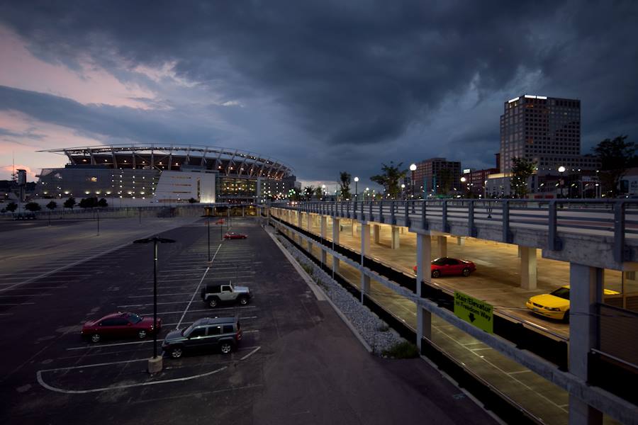
Central Riverfront Garage
Thousands of parking spaces sit largely empty outside of business hours and game days. Photograph by Jake Mecklenborg for UrbanCincy.

In April 2012, just weeks after UrbanCincy laid the groundwork for reforming the city’s parking policies, Vice Mayor Roxanne Qualls (C) and Councilmembers Yyvette Simpson (D), Wendall Young (D), Cecil Thomas (D), Chris Seelbach (D), and Laure Quinlivan (D) signed a motion urging the removal of all parking requirements in the central business district and Over-the-Rhine.

While the newly approved ordinance does not go quite that far, its proponents believe it is a step in the right direction.

“The goal of the ordinance is to encourage development in the urban core by permitting developers to determine their own parking needs for downtown developments,” explained Councilwoman Simpson, who is vice chair of council’s Livable Communities Committee. “I firmly believe that the market will work to meet parking demands better than government minimum parking requirements.”

According to Victoria Transport Policy Institute, individual parking spaces add anywhere from $10,000 to $25,000 to the cost of a development, and city council believes that by eliminating those mandates that they will make the center city an even more attractive place for private investment.
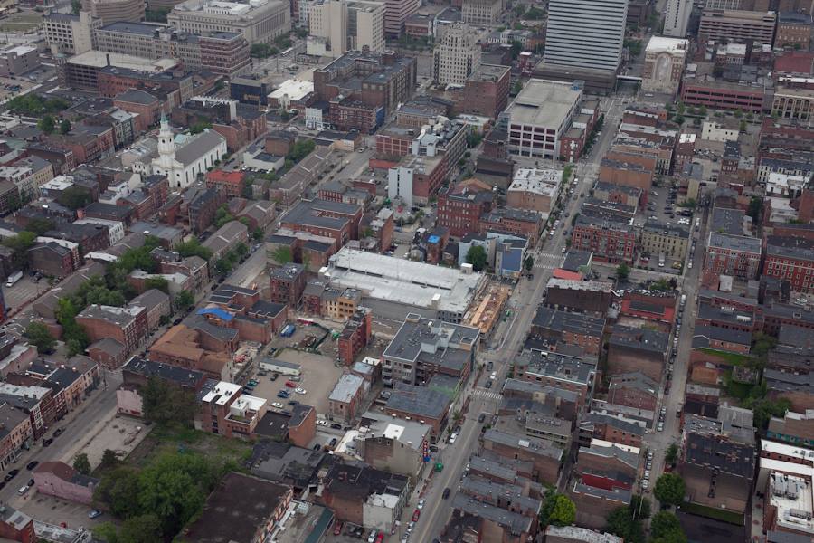
Mercer Garage
The Mercer Garage in historic Over-the-Rhine is visible from above in May 2013. Photograph by Jake Mecklenborg for UrbanCincy.

The discussion about parking mandates in the center city has been ongoing for years, and has taken on more prominence as private real estate investment in Over-the-Rhine has surged. UrbanCincy specifically called into question the size of the Mercer Commons parking garage in mid-2012.

The work of eliminating parking requirements, however, may not be finished.

The approved ordinance also calls for the “deregulation of minimum parking requirements in other neighborhoods through the establishment of Urban Parking Overlay Districts in areas to be determined by Council.”

If and when city council decides to move forward with establishing new Urban Parking Overlay Districts, there would be no parking requirements for any use other than residential developments greater than 20 dwelling units. This is slightly different than the modification to the Downtown Development Overlay Districts since they still require some minimal parking requirements for office uses.

One of the earliest beneficiaries of the new standards might be the renovation of 906 Main Street, which would not need to provide any parking spaces under the new standards. The $400,000 project will transform the largely vacant structure into 20 apartments above 6,705 square feet of street-level retail.

The new ordinance took effective immediately.

“This ordinance will encourage private investment by reducing the amount of government regulation,” Simpson continued. “This also encourages a walkable, pedestrian-friendly urban core, which is more attractive to residents and visitors.”

Categories
Business News Transportation

Metro Celebrates 40 Years of Transit Service in Cincinnati

Mass transit in Cincinnati has been around for 124 years, but the service provided by Metro is still 40 years young. The first buses in the Queen City arrived in 1926 and had grown in popularity by the 1960s.

During this time, it was managed by a private company named Cincinnati Street Railway. In 1973, the City of Cincinnati and Southwest Ohio Regional Transit Authority (SORTA) partnered to establish Metro in order to improve ridership and the quality of the buses. It was then Metro became the city’s first publicly owned and operated transportation system.

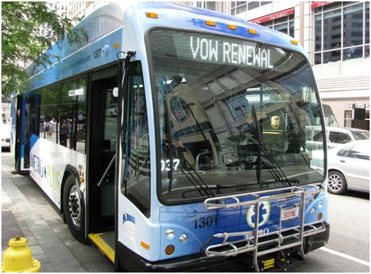
Metro 40th Anniversary Vow Renewal
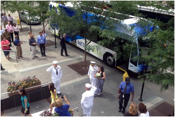
After meeting on Metro’s first day of service 40 years ago, Captain Rex and Anita Settlemoir renewed their wedding vows on Thursday. Photograph by Paige Malott for UrbanCincy.

To celebrate their 40th anniversary, Metro hosted an afternoon of festivities on Fountain Square. Four buses were displayed along Fifth Street, including a vintage Cincinnati Street Railway bus which had been preserved by the Cincinnati Transit Historical Society.

Local vendors Queen City Bike, Cincinnati and Hamilton County Public Library, Cincinnati Parks, and the Transit Authority of Northern Kentucky (TANK) handed out freebies while Binny and Buddy, mascots for Rumpke and Hoxworth Blood Center, entertained the crowd. Metro’s booth even featured a spin-the-wheel game were participants could win an assortment of products from Metro including hand sanitizer, tote bags, or miniature model Metro buses.

“We’re celebrating 40 years of connecting people and places, supporting economic development and improving the quality of life in Greater Cincinnati,” announced Terry Garcia Crews, CEO of Metro.

In addition to celebrating the organization’s anniversary, a local couple celebrated their 40th anniversary as well. Captain Rex and Anita Settlemoir met while riding Metro in during its first year of service. The Settlemoirs took part in a wedding vow renewal and were escorted to Fountain Square by a Metro*Plus bus; the newest vehicle introduced to the fleet.

“You could just hear the love and see it in their eyes,” smiled Jill Dunne, Public Affairs Manager for Metro.

With 40 being the new 20, the city wonders what’s next for Metro.

“Metro has so many exciting things ahead,” explained Dunne. “Next week, we launch our Metro*Plus rapid bus service in the Montgomery corridor, and we are adding new connections on the west side, as well as more east-west routes.”

“And that is just the start!” Dunne laughed. “I can’t even imagine what our service will look like in 2053. I’m hoping for flying buses.”

Categories
News Transportation

VIDEO: Biking from Cincinnati’s Fountain Square to the Ohio Statehouse in Columbus

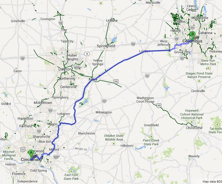
In September 2009, UrbanCincy’s Jake Mecklenborg biked from Cincinnati’s Fountain Square to the Ohio Statehouse in Columbus.

The ride documents the state of bike paths, or stretches of roadway, between the two cities. The approximate 125-mile journey relies heavily on the Little Miami Scenic Trail. But as Jake experienced, the usage of the trail drops off significantly once you get out of the city.

Another issue experienced during the ride was the lack of trail or dedicated bike facilities heading into Columbus.

One of the other trails that Jake partially uses on the trip is the Ohio River Trail, which is still under development. Officials with the City of Cincinnati continue to make progress on new segments of that trail, but it is still a ways off from its completion of connecting the Little Miami Scenic Trail with Smale Riverfront Park in downtown Cincinnati. Future extensions of the trail would bring it even further west along Cincinnati’s waterfront.

The City of Cincinnati is also studying a new dedicated bike lane along Delta Avenue that would lead to the Ohio River Trail. Those that are interested in weighing in on that project can do so by voting for your preferred design option online.

Categories
Development News Politics Transportation

Financing Falling Into Place for $108M MLK Interchange Project

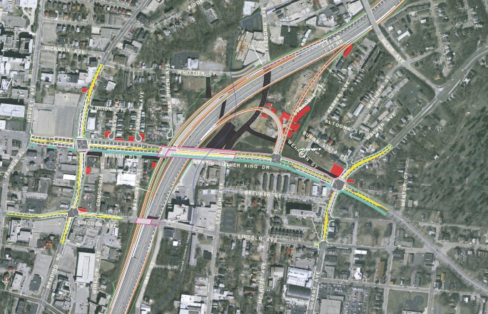
Planning and financing is progressing for construction of a new interchange between E. Martin Luther King Drive and Interstate 71. The $108 million MLK Interchange will fill the most obvious gap in the area’s expressway system – zero access to Uptown from northbound I-71 and circuitous access from southbound I-71 via the William Howard Taft ramp.

The Taft and McMillan ramps will remain under the state’s current plans, but the new MLK Interchange will become the preferred point of access for the University of Cincinnati, Children’s Hospital, the Cincinnati Zoo, University of Cincinnati Medical Center and surrounding residential neighborhoods.

MLK Interchange Site
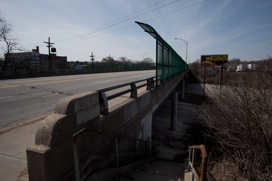
Martin Luther King Drive as it passes over I-71 presently. Photograph by Jake Mecklenborg for UrbanCincy.

In addition to the MLK Interchange, the Ohio Department of Transportation (ODOT) broke ground on the reconstruction of I-75’s Hopple Street Interchange. This project will reconfigure W. Martin Luther King Drive west of McMicken Street to meet Hopple Street on a new bridge above Central Parkway.

Two years ago UrbanCincy reported on these two transformative projects, planned for each end of Martin Luther King Drive, which will dramatically change the way motorists access the region’s second largest employment center.

The MLK Interchange has been the subject of considerable attention during the first half of 2013 due to the controversy generated by COAST when it worked to block Cincinnati’s Parking Modernization & Lease deal. The deal, which is now proceeding after a lengthy legal battle, was originally envisioned as the source for the $20 million local contribution to the interchange project.

In addition to blocking the parking deal temporarily, the injunction prevented the City of Cincinnati from passing emergency ordinances. This detail jeopardized the streetcar project, as it was timed perfectly to coincide with council’s need to allocate additional funds after construction bids returned much higher than expected.

MLK Interchange Preferred Alternative
Financing is beginning to fall into place to fund the preferred alternative for the $108M MLK Interchange. Provided.

In April, an effort led by COAST and City Council member Chris Smitherman (I) gathered the necessary signatures to place the parking lease ordinance on the November 2013 ballot. However, on June 12, the parking lease injunction was overturned by Judge Penelope R. Cunningham, wife of anti-streetcar and anti-parking lease 700 WLW talk host Bill Cunningham.

With the ballot issue avoided, streetcar and MLK Interchange planning resumed.

On July 9, the Ohio Controlling Board approved $4.2 million for property acquisition near the planned MLK Interchange in anticipation of a July 2014 start date for the project. Then, on July 22, Ohio Governor John Kasich (R) announced that a portion of his $3 billion lease of the Ohio Turnpike will fund the state’s contribution for the project.

The turnpike deal, which is similar in its strategy to Cincinnati’s parking lease, has hypocritically been spared the legal obstructionism of COAST or the criticism of talk radio hosts.

The City of Cincinnati is hosting a neighborhood meeting on July 24 at the Hampton Inn & Suites in Corryville at 3024 Vine Street between 5pm and 7pm. According the city, the meeting is “intended to guide the Uptown neighborhoods, institutions and city in visioning the future character and nature for the corridor.”

City officials say that formal presentations will be given on the half-hour, and that those who are unable to attend can still submit their comments or questions until Friday, August 2, 2013. Those wishing to submit their comments outside of the meeting can either email info@uptownconsortium.org or send in written correspondence to the Uptown Consortium at 629 Oak Street, Suite 306, Cincinnati, OH 45206.

Categories
News Transportation

Cincinnati Seeking Feedback on Two Bike Infrastructure Projects

The City of Cincinnati is studying two new streets for potential bicycle enhancements, and officials with the Department of Transportation & Engineering (DOTE) are looking for the public’s feedback.

The first project is on Delta Avenue where they are considering adding a five-foot bike lane on both sides of the street, and the second is a larger project along Central Parkway that is considering adding either striped bike lanes or physically separated cycle tracks along a 2.2-mile stretch of the roadway.

Delta Avenue Bike Lanes
The Delta Avenue project will take place between Columbia Parkway and Erie Avenue, but will not impact Mt. Lookout Square. DOTE officials say that the schedule calls for repaving to begin in early 2014.

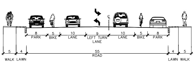
Right now planners and engineers are looking at two options for Delta Avenue. One option would maintain the existing roadway conditions that include two 10-foot travel lanes and two 18-foot travel/parking lanes.

Delta Avenue Proposed Section

The second option would modify this layout to include two 5-foot bike lanes, two 10-foot travel lanes, one 9-foot left turn lane, and two 8-foot parking lanes.

The proposed reconfiguration, DOTE officials say, would provide safety benefits for bicyclists, pedestrians and automobile drivers, and is similar to what was recently installed on Madison Road between Woodburn Avenue and O’Bryonville.

In addition to improving bicycle accessibility along Delta Avenue, the new bike lanes would connect into the recently installed bike lanes on Riverside Drive, which will be extended into the downtown area later this year.

“Delta Avenue is a primary cycling route from Riverside and downtown to the city’s eastern neighborhoods, and these plans will help to calm traffic and make the street safer for cyclists, pedestrians and motorists,” Queen City Bike president Frank Henson stated.

Those interested in sharing their feedback regarding the Delta Avenue project can do so by visiting the City of Cincinnati’s webpage for the project and answering a few brief questions.

Central Parkway Cycle Tracks
The larger Central Parkway project is planned to be built in two phases, with the first phase of work stretching from Elm Street in Over-the-Rhine to Marshall Avenue in Fairview.

Neighborhoods along the first phase of the project have already been approached about the project, and the City of Cincinnati received a $480,000 Transportation Alternative grant from the federal government, administered through the OKI Regional Council of Governments, in June 2013.

This portion of the work is being studied in three separate segments due to existing roadway configuration.

Dearborn Street Two-Way Cycle Track
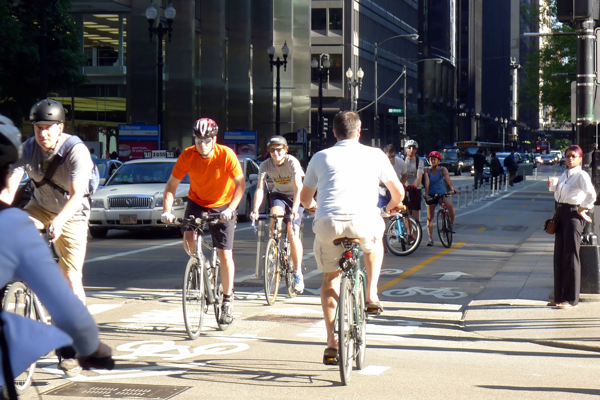
City officials are looking into the possibility of installing a two-way cycle track along Central Parkway – similar to Chicago’s two-way cycle track on Dearborn Street. Image provided by Active Transportation Alliance.

The first segment is from Elm Street to Liberty Street, and due to the median that divides Central Parkway there, it is considered unfeasible to have a two-way cycle track. As a result, the DOTE is considering only two options – the existing road with no enhancements or one-way cycle tracks on both sides of the street.

The second segment being studied in phase one is from Liberty Street to Brighton Avenue, and is studying three options in addition to the existing conditions. The first would be a 14-foot, two-way cycle track on the west side of the street, the second would be 7-foot-wide one-way cycle tracks on both sides of the street, and the third would be 5-foot bike lanes on both side of the street.

The final segment within the first phase of the Central Parkway project is from Brighton Avenue to Marshall Avenue. Here, the same three options are being considered as for the second segment. The only difference being the two-way cycle track on the west side of the street would be 12 feet wide instead of 14 feet.

“Adding a cycle track to Central Parkway will create a safer, family-friendly space for people on bicycles and will exponentially increase the number of people using bicycles in this corridor,” explained Mel McVay, senior city planner with Cincinnati DOTE. “This project is a game changer for Cincinnati – it has the ability to completely change the way people feel about riding bicycles in our city.”

Those looking to share their thoughts on which design option would be best can do so by completing a very short survey on the Central Parkway project’s webpage.

The second phase of work along Central Parkway would then progress northward from Marshall Avenue to Ludlow Avenue, where the city’s first green bike lanes were installed in November 2012. The details have not yet been worked out for this phase of work, but will progress as soon as funds become available.

“Both of these projects would be extremely beneficial if completed,” noted Queen City Bike executive director Nern Ostendorf. “What bike lanes and especially cycle tracks do is they expand the accessibility of biking on city streets to more users who consider biking on roads without special bike facilities too dangerous, or at least too stressful.”

This story was originally published in the July 19, 2013 print edition of the Cincinnati Business Courier. UrbanCincy readers are able to take advantage of an exclusive digital membership and access all of the Business Courier‘s premium content by subscribing through UrbanCincy‘s discounted rate.