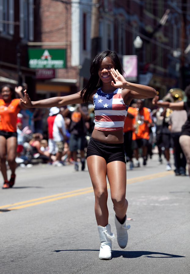
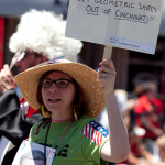
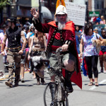
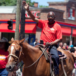
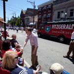
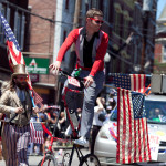
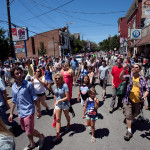
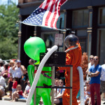
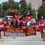
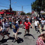
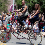
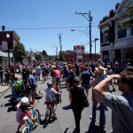
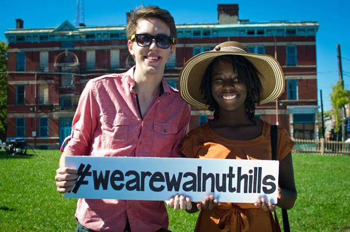
After the Northside Fourth of July Parade came back to life in 1970, it has served as an annual fixture in the neighborhood. Over the years the crowds have grown and the parade has become a must-stop for any politicians looking to win votes in the city.
Aside from being one of the most significant and well-attended parades in the region, the Northside Fourth of July Parade is also one of the more eclectic.
EDITORIAL NOTE: All 49 photographs in this gallery were taken by Jake Mecklenborg on Friday, July 4, 2014.
While the development boom being experienced in New York City, Paris and London isn’t quite the same in Cincinnati, the Queen City does share in some of these issues surrounding historic preservation. Some believe that protecting and preserving historic structures is a barrier for development.
This has been seen most recently in the easy approval of the updated Lytle Park Historic District boundary, which is now much smaller than it once was. The reason such changes received easy approval at City Hall is because of the promise of new development, but is that the correct way to think about it? More from Next City:
American preservationists, too, have become so accustomed to pushing for the enforcement of preservation laws that they often are stereotyped as gatekeepers of nostalgia. Those who fought New York Mayor Michael Bloomberg’s plan for upzoning part of Midtown Manhattan were demonized as anti-development. In truth, they were trying to protect the existing development. Polyphonic streetscapes of buildings of varying heights, styles and forms blended with smart new design attract people.
[…]
Preservationists are mediators between cultural heritage and economic demands, and they often don’t win what they want. The rambling mass of buildings joined under La Samaritaine’s walls and the stately mass of Cleveland’s Fifth Church of Christ, Scientist are far from evident in the remaining fragments. Yet what has actually been saved in both cases is invisible: the integrity of preservation laws, the enhanced value of developments that incorporate elements of the past and the continuity of urban character that makes cities continue to be desirable places. Years later, no one will see the battle scars from these fights, but they will see interesting works of contemporary architecture based on historic elements, thanks to preservation activists fighting overbearing design.
UrbanCincy‘s most popular stories in June were clear signs of the progress being made in Cincinnati. While a modest number of new residents have been added over the past four years, the urban core and surrounding neighborhoods continue to grow with new residential developments.
Two of the stories (#2 and #5) are in sharp contrast: while Cincinnati received national praise for its form-based code efforts, Norwood missed an opportunity and ended up with an auto-oriented development in its core.
As you enjoy your Independence Day weekend, we invite you to catch up on our top stories from June that you may have missed:
For the past few years anyone with an interest in bicycling has seen their Facebook and Twitter feeds stuffed daily with bike lane and bike share project updates from cities around the United States. Much of that news has come from our northern neighbor Chicago, where its first of 100 planned miles of protected bike lanes opened in 2012.
In 2013 Chicago also launched the nation’s third-largest bike share program, a 300-station network sprawling across large sections of the city. Then, in early 2014, construction began on the $60 million Navy Pier Flyover, an elevated structure that will speed Lakefront Trail bicycle traffic over the Chicago River and the congested Navy Pier tourist area.
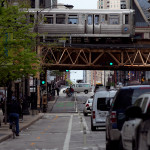
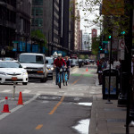
In May I spent part of a vacation day biking 35 miles around Chicago to see its various recent bicycling improvements for myself. This ride included The Loop, parts of the Lakefront Trail, and various residential areas where bike lanes have been recently created.
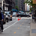
Dearborn Street Two-Way Protected Bike Lane
This two-way protected bike lane opened on the otherwise one-way Dearborn Street in November 2012, and is among the most talked-about new bike lanes in the country. It occupies a 10-foot wide strip on the west side of this major north-south street, with bikes separated from vehicular traffic by bollards and on-street parking.
Dearborn Street Protected Two-Way Bike Lane [Jake Mecklenborg]
To manage conflicts between two-way bike and one-way automobile movements, bicycle traffic is controlled by dedicated signals at about a dozen intersections in The Loop.
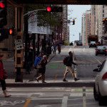
I biked the length of this protected lane in both directions beginning at about 4:50pm on a weekday. It was immediately obvious that travel in the lane during rush hour was not particularly fast or orderly — pedestrians often stepped into the bike lane to hail cabs or to cross Dearborn Street mid-block. At cross-streets, bicycle traffic was sometimes unable to proceed when signaled due to surges of pedestrians or gridlocked traffic.
Commuters riding their own bikes often passed slower Divvy bikes and northbound bikers sometimes drifted between the protected bike lane and Dearborn’s vehicular lanes. I observed a handful of northbound bicyclists ignoring the protected bike lane altogether, instead biking in mixed vehicular traffic up Dearborn Street as they had for the past 100 years.
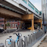
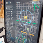
Divvy Bikeshare
Chicago’s “Divvy” bike share system began operation on June 28, 2013 and by year’s end the system logged over 700,000 trips. This year the system is planned to expand from 300 to 400 stations and add 1,000 bicycles to its existing fleet of 3,000.
To say that the Divvy bikes are popular would be a gross understatement – the extent to which the blue bicycles have become a ubiquitous feature of Chicago’s cityscape in their first year has no doubt silenced all critics.
Similar questions have been raised locally and intensely debated on Internet forums. The questions bear enough validity to cause many proponents of Cincy Bike Share to concede that Uptown and Downtown operations may function and serve different customers from one another.
Navy Pier Flyover
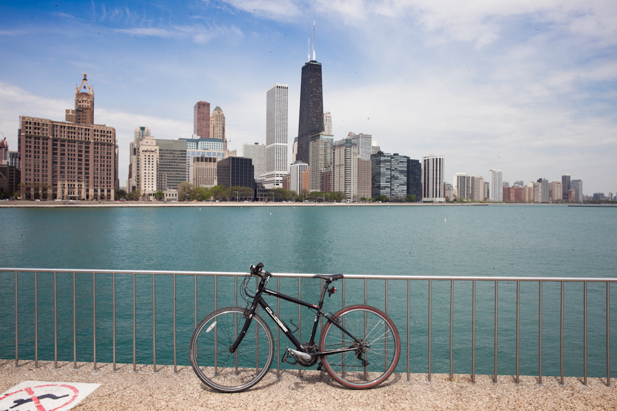
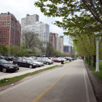
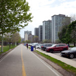
Chicago’s Lakefront Trail stretches 18 miles along the city’s lakefront, and is home to a crush of bicycle traffic unlike anything to be seen in Cincinnati or elsewhere in the Midwest. In fact, the Active Transportation Alliance claims that Lakefront Trail is the busiest in the United States with peak daily usage reaching 30,000 people at key points.
Every type of bicycle and every type of rider uses the trail, along with joggers, walkers, and inline skaters – motivating the Chicago Tribune to remark earlier this year that the Lakefront Trail is “claustrophobic and dangerous—the antithesis of the shoreline as a refuge from urban crowding.”
Chicago and Lake Michigan [Jake Mecklenborg]
Lakefront Trail Northbound [Jake Mecklenborg]
Lakefront Trail Southbound [Jake Mecklenborg]
The Navy Pier Flyover will link the north and south halves of the trail with 16-foot wide elevated approaches to the Outer Drive Bridge. The trail will cross the Chicago River on a new structure cantilevered off the west side of the famed 77-year-old bascule bridge.
General Observations
As someone who grew up biking the monster hills and hostile commercial avenues of Cincinnati’s west side in the 1980s, riding in Chicago – even the many areas without new bike lanes — is by comparison a piece of cake. So easy in fact that it’s boring.
Virtually all of Chicago’s streets are perfectly flat, perfectly straight, and traffic moves at pretty much the same speed and in the same fashion on all of them. There is little to no sense of exploration and discovery during a bike ride around Chicago – no wonder the Lakefront Trail is so popular when a ride between any two neighborhoods has the same character as any other combination.
No Chicago bicyclist knows anything like our varied street characteristics, our innumerable odd intersections, and of course the two-mile downhill runs that can be strung together between various Cincinnati neighborhoods.
Experimenting with side streets and alternate routes between points A and B is something that keeps the avid Cincinnati bicyclist exploring the city, year after year, and familiarity with all of the hills is a point of pride.
When Cincinnati’s bike share begins later this year, and if we eventually build more protected bike lanes beyond the current Central Parkway project, no doubt bicycling will become more popular in the center city, basin neighborhoods, and across the river in Covington and Newport.
Any city, however, can paint bike lanes and buy a few thousand bike share bikes, but the endless range of leisurely or challenging rides available to the Cincinnati bicyclist is something Chicago and most other American cities will never have.
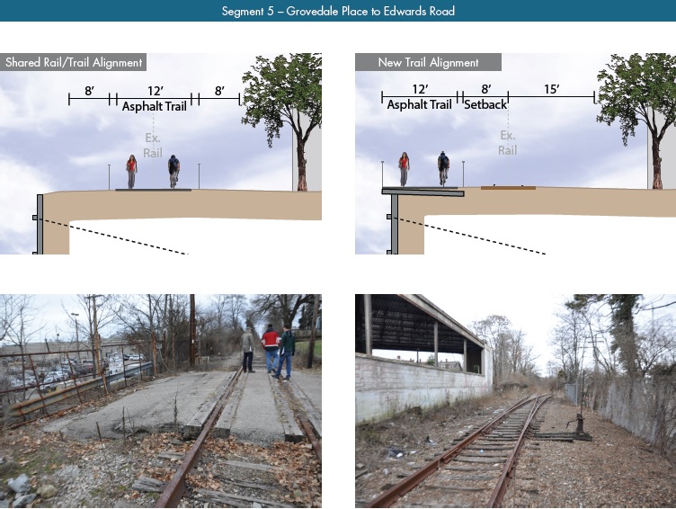
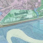
A newly released feasibility study, produced by KZF Design, finds that construction of the 6.5-mile Wasson Way Trail would cost anywhere from $7.5 million for just a trail to $36 million for both a light rail line and trail totally separated from one another.
The cost estimates vary so much due to the three potential design options studied. The lowest cost alternative looked at placing a 12-foot-wide trail along the entire existing rail alignment. This, however, would make the inclusion of a future light rail line extremely difficult.
The most expensive alternative would construct an entire new trail alignment that does not interfere with any existing rail right-of-way. This would include the construction of several new bridges and completely preserve the ability to easily construct the long-planned light rail line adjacent to the new trail.
Alternative B, which was recommended by KZF and priced at $11.2 million, was a bit of a hybrid. It would include a 12-foot-wide trail offset from the existing rail alignment, but utilize existing rail right-of-way at pinch points along the corridor.
The 45-page study is the first detailed look at the corridor, which has been hotly debated and discussed over recent years. Much of the controversy has surrounded whether or not both light rail and a trail can be accommodated. KZF’s findings appear to show that much of the corridor could in fact accommodate both, but that some segments may prove to be difficult, albeit feasible.
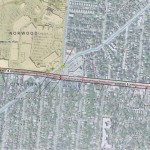
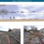
Segment 1 – Montgomery Road to Elsmere Avenue
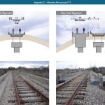
Segment 2 – Elsmere Avenue across I-71
Segment 3 – I-71 to Kendall Avenue
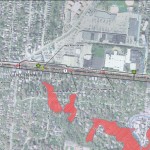
Segment 4 – Kendall Avenue to Grovedale Place
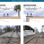
Segment 5 – Grovedale Place to Edwards Road
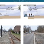
Segment 6 – Edwards Road to Paxton Avenue
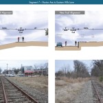
Segment 7 – Paxton Avenue to Eastern Hills Lane
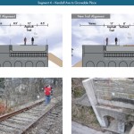
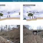
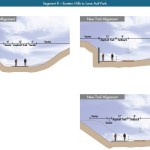
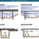
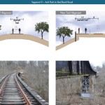
Segment 8 – Eastern Hills Lane to Ault Park
Segment 8 – Eastern Hills Lane to Ault Park 2
Segment 8 – Eastern Hills Lane to Ault Park 3
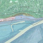
Segment 9 – Ault Park to Red Bank Road
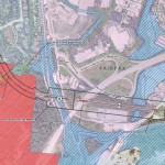
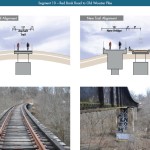
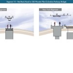
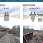
Segment 10 – Red Bank Road to Old Wooster Pike
Segment 10 – Red Bank Road to Old Wooster Pike (Columbia Parkway Bridge)
Segment 10 – Red Bank Road to Old Wooster Pike (Old Wooster Bridge)
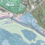
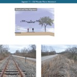
Segment 11 – Old Wooster Pike to Mariemont
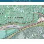
Segment 12 – Mariemont to Wooster Pike
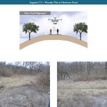
Segment 13 – Wooster Pike to Newtown Road
If project supporters are able to advance the trail plan, KZF estimates that it would connect eight city neighborhoods and approximately 100,000 residents with an overall network of more than 100 miles of trail facilities.
“It is hard to build in the urban core, and to find an intact corridor ripe for development is a unique thing,” explained Eric Oberg, Manager at the Midwest Rails to Trails Conservancy. “If this is done right, this can be the best urban trail in the state of Ohio. I have no doubt.”
Some of the most difficult segments of the corridor are the nine existing bridges where the right-of-way is extremely limited. If both light rail and trail facilities are to traverse this corridor together, additional spans will be needed in order to have safe co-operation.
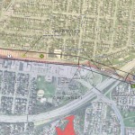
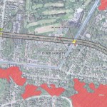
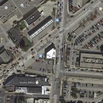
Intersection at Wasson, Edwards and Madison Roads in Hyde Park [Google Maps]
In addition to introducing what may become the region’s best urban trail and light rail corridor, some proponents also see it as an opportunity to fix other problems along the route. Most notably that includes the congested and confusing intersection of Madison, Edwards and Wasson Roads near Rookwood Pavilion.
While the newly released feasibility study offers the most detailed analysis of this corridor to date, the City of Cincinnati has yet to close on its purchase of the former freight rail line from Norfolk Southern.
City officials are reportedly in negotiations with Norfolk Southern now, and have made an initial offer of $2 million. In April, Mayor Cranley’s Administration also allocated $200,000 to the project.