Categories
Up To Speed

New York City, Chicago rapidly advancing progressive transport policies

New York City, Chicago rapidly advancing progressive transport policies.

New York City and Chicago are blazing a progressive path towards a sustainable transport network. Cincinnati has made minor strides with regards to bicycle infrastructure and Complete Streets, but much is being left on the table in the Queen City and elsewhere. More from Grid Chicago:

I hadn’t been to New York since 2008 when I checked out their Summer Streets ciclovia. Since then Manhattan has gone through an amazing transformation under Mayor Michael Bloomberg and transportation commissioner Janette Sadik Khan. Besides implementing the bike lanes, they pulled off the ultimate road diet on Broadway, removing car lanes and shutting down sections of the island’s main diagonal thoroughfare to calm traffic and make space for some amazing new car-free spaces. And I didn’t even have time to check other first-rate bike facilities in Queens and Brooklyn, or the new segments of the Highline, the sleek, 1.5-mile elevated linear park which paved the way for Chicago’s Bloomingdale.

Categories
Business News Transportation

Nate Wessel aiming to change the way Cincinnati does maps

Maps are used in our everyday lives to help us navigate our cities, perform research, and visualize spatial data, but Nate Wessel has attempted to change the way Cincinnatians view such information.

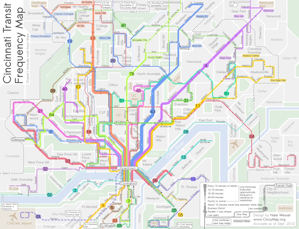
In June 2011, Wessel started a modest Kickstarter campaign that would raise money to print a transit frequency map he had developed. Instead of using the typical approach to developing a bus system map, Wessel adjusted colors and line weights according to the frequency of service along each bus route.


Cincinnati Frequent Transit Map (Day Time). Image provided by Nate Wessel.

While he simplified the system map, he also added critical wayfinding information such as neighborhood business districts, parks, neighborhoods and natural landscape features.

“The maps used currently will put the 38X on the same visual level as the 17, but one runs three times a day in each direction, and the other runs almost 100 times a day in each direction,” Wessel explained. “In no way does the map indicate any more value for one over the other, but my map gives people an approximate idea of how long you’ll need to wait, in addition to how frequent the buses come and where they go.”

Wessel grew up in Northeast Ohio and said that his first experience with transit was biking a mile to an unmarked bus stop in Canton. Since then he has studied urban planning at the University of Cincinnati (UC) and worked with the U.S. Department of Transportation, Bureau of Transportation Statistics.

It was during his time at UC, when he realized something needed to change with the way transit information is visually presented.

“A friend of mine from China was basically saying that he felt trapped in his apartment, and didn’t know anything beyond campus and thought you could take transit, but didn’t know where it went,” recalled Wessel. “He lived in a transit-rich area, but many people like him didn’t know the correct routes to take to the right places, even easily accessible places like downtown.”


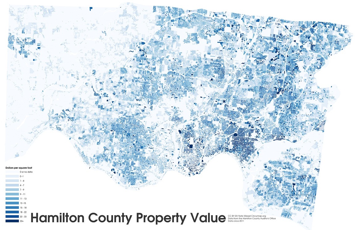
Hamilton County property values by square foot. Image provided by Nate Wessel.

The initial Kickstarter campaign raised far more money that Wessel was anticipated, and he was able to print and distribute 30,000 copies of his Cincinnati Transit Frequency Map. The map is now also featured on Southwest Ohio Regional Transit Authority’s (SORTA) website, but beyond that has not made significant inroads with regional transportation agencies.

Six months after Wessel distributed his new map, SORTA released a new regional transit map, for which they paid $20,000, that lacked the intuitive display and added information presented on the Cincinnati Transit Frequency Map.

While both SORTA and the Transit Authority of Northern Kentucky (TANK) were originally cooperative, and even contributed financially to the Kickstarter campaign, the follow-up, Wessel says, has been a bit disappointing.

Since the original release and distribution of the frequency map, Wessel has continued to improve upon it while also developing a separate night-time map, and one that focuses on center city transit service. To support those efforts, he launched a second Kickstarter campaign which funded the production of 20,000 additional maps in September 2012.

Wessel, however, has not limited himself solely to transit maps. He has released a number of maps this year that have highlighted property value data in Hamilton County, provided an exhaustive analysis of SORTA’s new transit plan, explained the theory of bus bunching, and is in the midst of an eight-part series critiquing the Cincinnati Streetcar project.

In the future he hopes to do a comprehensive map for bicycling to replace the existing one produced by the OKI Regional Council of Governments (OKI).

“In some way it’s a common interest in Cincinnati that I share with a lot of people that see the city not doing things as awesome as compared to other places, so I kind of want to do that with information about transit and cartography,” Wessel explained. “I also want people to make informed decisions about transit and planning in general, and I think that putting as much information out there in an attractive and useful manner helps.”

Nate Wessel was the winner of UrbanCincy’s first featured profile contest at the September 2012 URBANexchange. If you have a great idea we should know about, please contact the us at urbancincy@gmail.com. URBANexchange events are held on the first Wednesday of every month at the Moerlein Lager House.

Categories
News Transportation

Cincinnati Moves Forward With Land Use Study of Wasson Railroad Corridor

On November 14, Cincinnati’s Department of City Planning & Buildings held a public hearing on its upcoming land use study for the disused Wasson Road Railroad and adjacent properties.

Norfolk-Southern Railroad ended service on the line in 2009, and in 2010 the City of Cincinnati’s Department of Transportation & Engineering (DOTE) identified the right-of-way as a future off-road bicycle path in its planned 400-plus-mile network of bike lanes and trails.

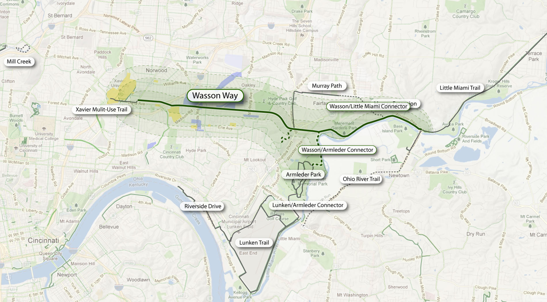
Local bicycle advocates have since built public support for construction of a paved rails-to-trails bicycle path between Xavier University and Fairfax as part of a project called the Wasson Way Trail.


The proposed Wasson Way Trail would use the Norfolk Southern Railroad right-of-way to create a bike trail from the Little Miami Trail to Xavier University. Image provided.

On Wednesday, however, city officials were quick to mention that the upcoming land use study is just that – a determination of how the Norfolk Southern property and its surroundings might be rezoned in order to protect the right-of-way up until and after the right-of-way is purchased by Cincinnati – not a determination of what should be built in its place.

Already, Norfolk Southern has leased some of its railroad property for other uses. In 2011, a shopping center at Wasson Road and Edwards Road created a gravel parking lot on the disused tracks and another business near Paxton Road is looking to do the same.

Although Federal regulations prohibit railroads from subdividing their disused properties until they complete an “abandonment” process, Wasson Way Trail advocates are concerned that revenue from additional leases might discourage Norfolk Southern from selling the right-of-way to the City of Cincinnati at a future date.

Michael Moore, Director of the City of Cincinnati’s DOTE, stated that appraisals of the Norfolk Southern property fall close to $2.5 million. He cautioned, though, that this appraisal should not be thought of as a sale price, as the terms of the City’s purchase of the property cannot be known at this time.

Multi-Modal Use of the Corridor
At the November 14 meeting, city officials also made a point of stating that the title of the upcoming land use study has not been determined but that it will make no explicit mention of bicycle paths, light rail transit, or multi-modal use of the corridor.


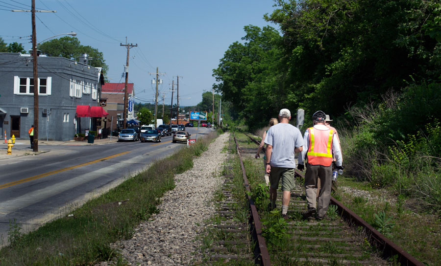
Members of Queen City Bike joined Cincinnati City Councilmember Laure Quinlivan (D) and former MetroMoves chairman John Schneider for a walk along the Wasson Railroad Corridor in May 2012. Photograph by Jake Mecklenborg for UrbanCincy.

Construction of a double track light rail transit line in the right-of-way was first identified by the OKI Regional Council of Governments in the late 1970s. Then in 2002, the Southwest Ohio Regional Transit Authority (SORTA) planned to build a light rail line in place of the Wasson Road freight railroad as part of its MetroMoves plan and failed sales tax referendum. If the ballot issue had passed, construction of a light rail line would have almost certainly commenced soon after Norfolk Southern ceased freight service in 2009.

The width of the Norfolk Southern right-of-way varies wildly as it travels between Xavier University and Hyde Park. It is typically at least 30 feet wide, but in a few places widens close to 100 feet.

In May 2012 members of Queen City Bike walked the right-of-way with John Schneider, who had previously chaired the MetroMoves campaign. At that time, the groups agreed that conflicts between the proposed bike path and light rail line can be avoided if the two are planned as a unified project.

Further complicating the issue is that small sections of the Norfolk Southern property fall under the jurisdiction of the City of Norwood. These sections are all north of the line’s main tracks, for example the railroad’s former yard tracks near Montgomery Road. As Norwood is not involved in Cincinnati’s upcoming land use study, and Cincinnati of course has no influence in its affairs, whatever zoning changes Cincinnati applies will not affect bordering Norwood properties.

The Department of Planning & Buildings will complete its land use study in summer 2013, but with no immediate plans to enter into negotiations with Norfolk Southern, there is no timeline for construction of the Wasson Way Trail.

Categories
Development News Transportation

Cincinnati becomes first Ohio city to install green bike lanes

Construction workers installed bright green bike lanes at three conflict points along Ludlow Avenue yesterday. The new green bike lanes are a first for Cincinnati as it continues to work towards making city streets safer for area bicyclists.

According to the National Association of City Transportation Officials (NACTO), experimentations with specially colored bike lanes first took place in the mid-1990s. Then, between 1997 and 1999, the City of Portland worked with the Federal Highway Administration (FHWA) to mark 10 conflict areas with blue coloring and accompanying signage. Since that time, the FHWA has determined that green is a more appropriate color for bike lanes on public streets, so as not to be confused with accessibility parking.


The City of Cincinnati used NACTO’s standard design for a truncated bike lane through an intersection as the basis for its green bike lanes on Ludlow Avenue. The installation makes Cincinnati the first Ohio city with green bike lanes.

Green bike lanes have begun to appear in cities throughout North America in recent years to not only mark areas of conflict, but also delineate entire bike corridors. In the Midwest, Chicago has led the charge using green bike lanes for entire cycle track corridors, bike boxes at traffic signals, and at special conflict points.

According to city officials, Cincinnati’s first application of green bike lanes will mark Ludlow Avenue where it intersects with Old Ludlow Avenue, Central Parkway and a driveway entrance to Cincinnati State (map). City planners also say that there will be additional green bike lanes to come.

“We are considering using green markings where the Gilbert Avenue bike lane will intersect with the right-turn lane into the casino,” explained Department of Transportation & Engineering (DOTE) planner, Melissa McVay.

McVay went on to say that City is using NACTO’s design guidelines and specifications for these projects, and that going forward, green bike lanes will be considered at all high conflict areas where motorists must cross a bicycle path.

The idea behind the green markings is to improve the visibility of bicyclists, and in the process, improving safety.

“In this [Ludlow Avenue] case the green lanes help negotiate cars desiring a right hand turn through a bike lane that continues straight ahead,” said Frank Henson, President, Queen City Bike. “By giving the bicycle lanes a different color, motorists realize that, in making their turn, they are crossing into another travel lane reserved for cyclists, and that they must yield to bicycle traffic in order to complete the turn.”

The City of Cincinnati Bicycle Transportation Program has installed 35.8 miles of bicycle facilities to-date, with an additional 289.9 miles planned in a citywide bicycle network.

And when asked about what could be done to continue to improve safety for Cincinnati-area bicyclists, Henson concluded that, “The best thing the City of Cincinnati can do to improve safety for street cycling is to continue to carry out the Cincinnati Bike Plan, improving the network of bike routes, lanes, trails, and paths in the area. Better education and enforcement of traffic law for both cyclists and motor vehicle operators is also necessary.”

We sat down with Melissa McVay on Episode 8 of The UrbanCincy Podcast to discuss Cincinnati’s bike culture – where we stand, how we got here, and what needs to take place next. You can stream that podcast online for free, or subscribe to The UrbanCincy Podcast on iTunes so that you don’t miss an episode.

Categories
Business Development Transportation

Cincinnati City Leaders to Move Forward with Ohio’s First Bike Sharing System

A new study, prepared by Alta Planning + Design, has determined how and where a bicycle sharing system could be implemented in Cincinnati in a way that will compliment its expanding Bicycle Transportation Program.

The recently released report was called for by city leaders in May 2012, and identifies a 35-station, 350-bike system that would be built over two phases in Downtown, Over-the-Rhine, Pendleton, Clifton Heights, Corryville, Clifton, Avondale and the West End.

“We went into this study wanting the public to be a big part of the process. They contributed more than 300 suggestions for stations and cast nearly 2,000 votes,” said Michael Moore, Director of the Department of Transportation & Engineering (DOTE). “Thanks to all their input, this study helps ensure bike share is relevant and useful to the residents and commuters in the downtown neighborhoods.”
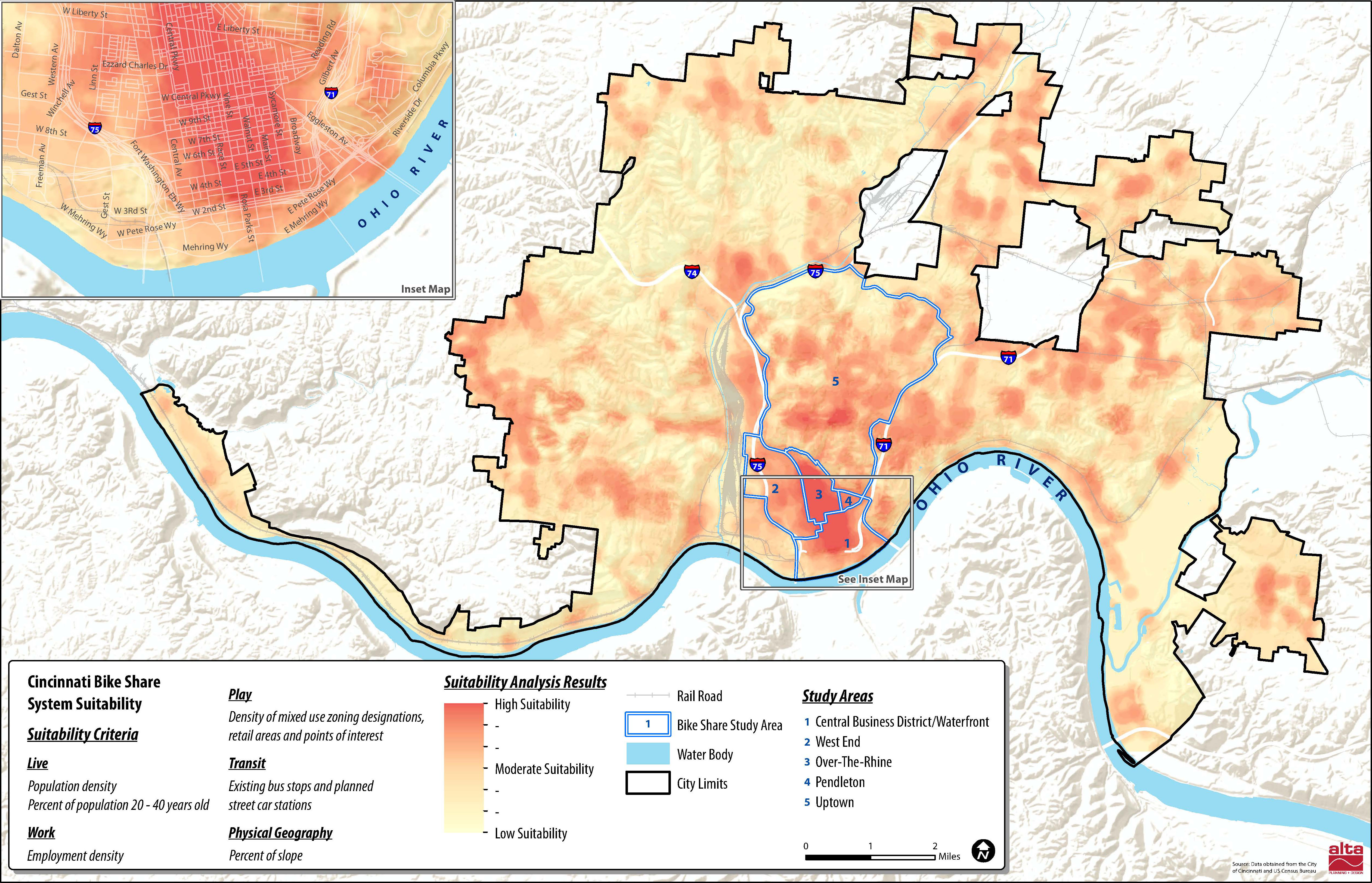

Several neighborhoods throughout the city were determined as potential areas to be included in a future Cincinnati bike share system. Map provided by Alta Planning + Design.

City officials also say that locations throughout northern Kentucky’s river cities were also popular, and would make for a logical expansion in the future should system arrangements be achieved.

According to the report, the 35 station locations were identified through public input and through a variety of suitability factors that include population density, percentage of residents between the ages of 20 and 40, employment density, mixture of uses and entertainment destinations, connectivity with existing and planned transit networks, and the terrain in the immediate area.

“In general, there are enough positive indicators to suggest that bike sharing is feasible in Cincinnati,” Alta Planning + Design wrote in the 49-page report. “There are no fatal flaws, although a smaller dependency on visitors and ordinances restricting advertising would need to be overcome to make the system financially viable.”

The financial viability of the project is particularly important in Cincinnati’s case as city officials have determined that a privately owned and operated system would be the best business model for Cincinnati.

Alta Planning + Design estimates that the potential 35-station system, spread throughout Downtown and Uptown, would cost approximately $2 million to construct and nearly $200,000 to operate annually. While user fees are expected to sustain a portion of the annual operating costs, system operators will most likely need a variance to city law to allow for advertising on the stations, as is commonplace for bike sharing systems throughout the world.
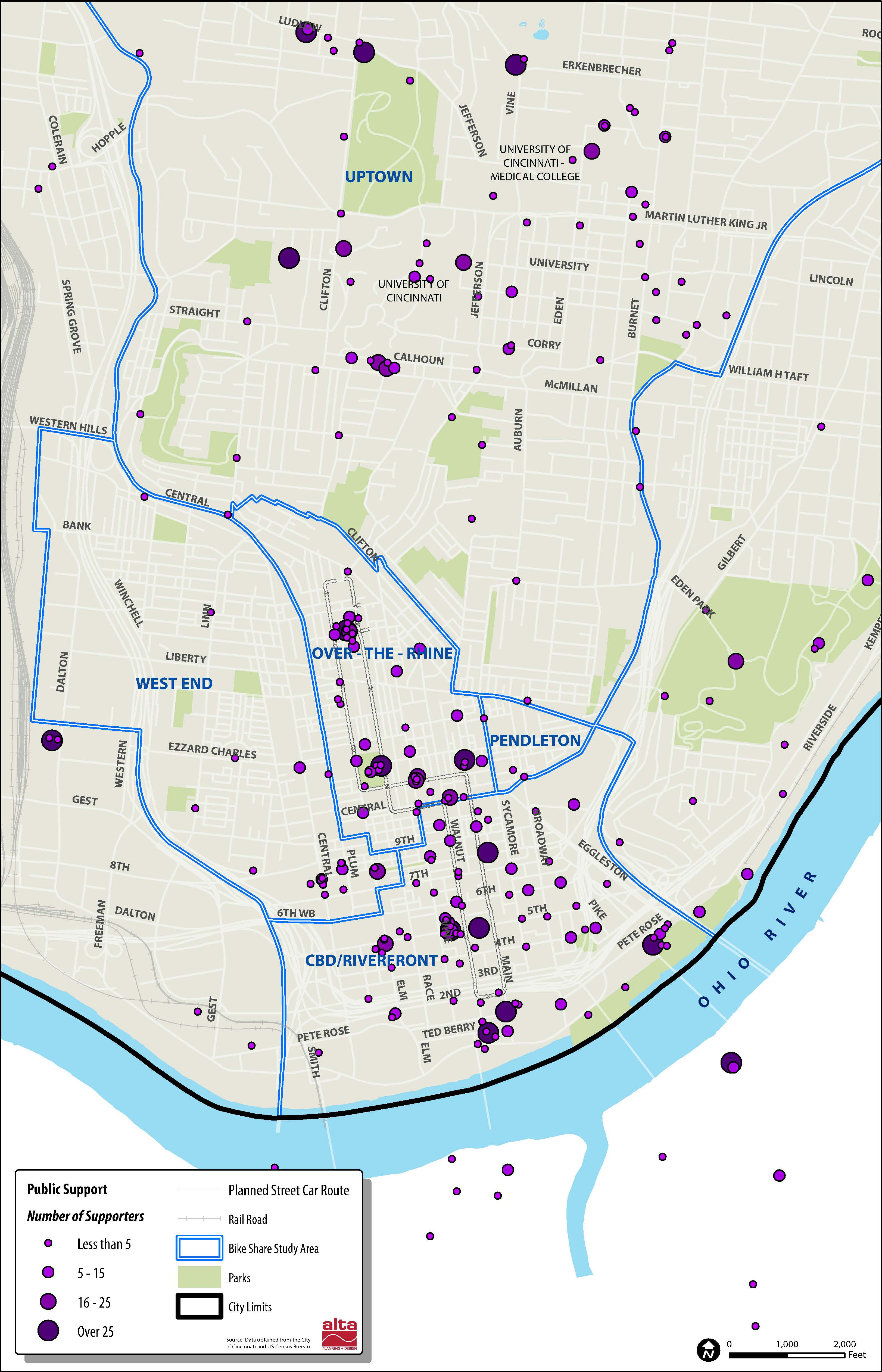
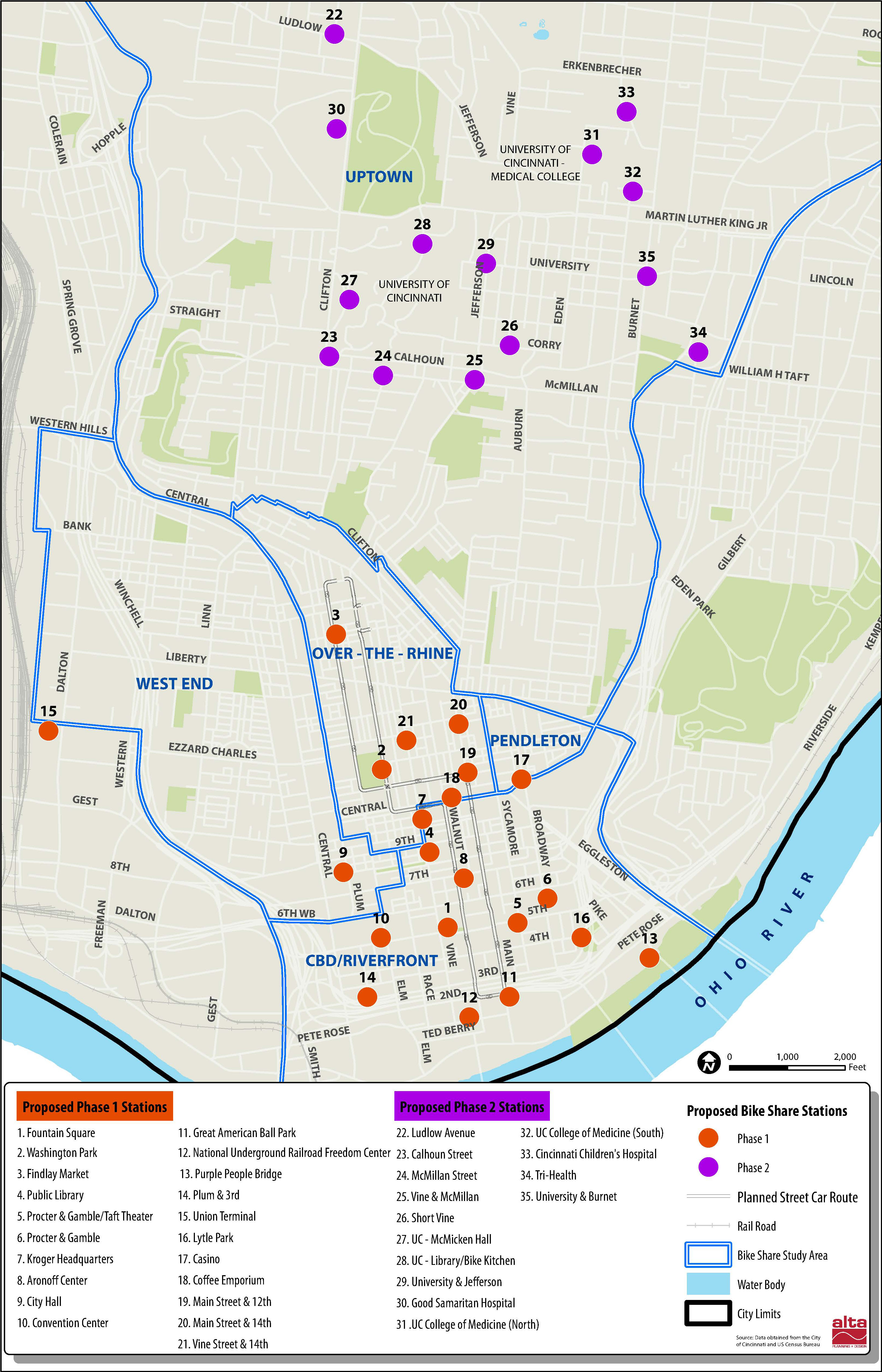
     
More than 2,000 responses helped determine public support for potential station locations [LEFT]. The initial system would be built out over two phases in Downtown and Uptown [RIGHT]. Maps provided by Alta Planning + Design.

“As of now we do not intend to invest any public funds in the system, other than in-kind assistance with marketing and station siting,” explained DOTE Senior City Planner Melissa McVay, who recently sat down to discuss Cincinnati’s bike culture on Episode #8 of The UrbanCincy Podcast.

Annual membership fees and hourly rates would be determined by the eventual company selected to operate the system, and would be contingent upon how much money could be raised through advertising and local sponsorships.

In addition to drilling into local details and demographics pertinent to a potential Cincinnati bike sharing system, the feasibility study also compared Cincinnati to other cities throughout North America that have operational bike sharing systems.

Through that analysis it was found that Cincinnati’s system would be smaller than those in Miami, Boston, Washington D.C., Montreal and Toronto, but that it would be larger than systems in San Antonio, Des Moines and Chattanooga. Cincinnati’s system is also anticipated to have a more favorable trip comparison, for the first year of operation, than both Minneapolis and Denver.

The report also estimates that Cincinnati’s system would attract 105,000 trips in its first year of operations, with that growing to 305,000 in year five once both Downtown and Uptown regions are operating, with approximately 25 percent of trips replacing a vehicle trip.

“We want Cincinnatians to be able to incorporate cycling into their daily routine, and a bike share program will help with that,” Moore explained. “Bike share helps introduce citizens to active transportation, it reduces the number of short auto trips in the urban core, and it promotes sustainable transportation options.”

The City of Cincinnati is expected to issue a request for proposals, within the next month, that will call for bids from an operator of the planned system. If all goes according to plan the Midwest’s sixth, and Ohio’s first, bike share system could become functional as early as the operator’s ability to acquire funding.