Categories
News Transportation

Bogota’s TransMilenio serves as model for Cincinnati’s planned BRT

Cincinnati is exploring the idea of implementing bus rapid transit (BRT) lines to create better transit access from the city’s inner-ring suburbs to the employment centers of downtown and uptown. The success of BRT is often determined before the first passenger ever boards. Design, routing and operation planning often determines the level of success experienced. As a result, UrbanCincy traveled to Bogota, Colombia to see how one of the world’s most famous, and successful bus rapid transit systems works.

Bogota’s TransMilenio system first opened in December 2000. The investment was made in lieu of a much more expensive, and invasive, highway building project to relieve congestion in Colombia’s largest city. Since that time, the TransMilenio’s reach has grown along with its popularity, now serving 1.5 million riders each day along its nine lines totaling 54 miles.
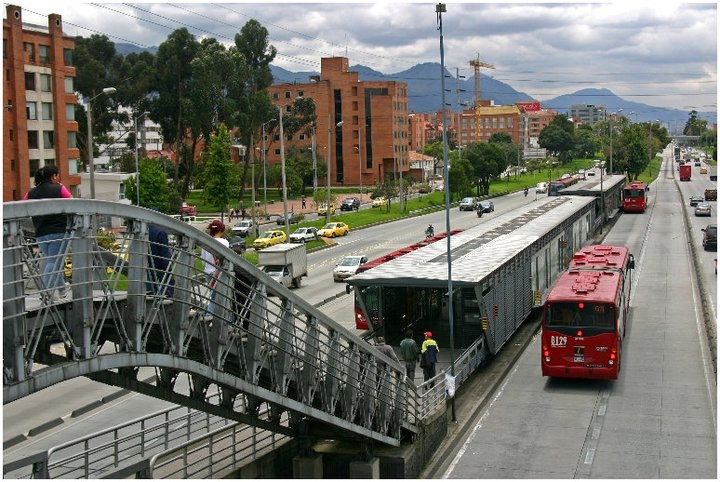

TransMilenio Peppe Sierra Estacion on Bogota’s north side. Photograph by Randy A. Simes.

Design
The TransMilenio operates in the center of major thoroughfares throughout Bogota. Riders often access the stations by crossing steel walkways that extend over the wide streets below. The stations also use similar steel framework and include glass doors that open when buses pull up to the platform.

The simple design helped to keep initial costs low ($9.6M per mile), but is showing signs of significant wear and tear. The open air stations also suffer from the extreme pollution from vehicle, truck and bus exhaust along the busy roadways.

The buses themselves are typically single-articulated red buses that are easily recognizable from the city’s plethora of private buses operating as circulators throughout the rest of the city. To accommodate more passengers, new double-articulated buses are now being integrated into the overall system as station design permits.

Routing
It is important to note that the TransMilenio only operates along major thoroughfares and functions much like an above-ground rapid transit system. The buses do not reach into neighborhoods and instead focus on moving people long distances along specific corridors. Other trips are better made by using the small, private buses operating on local streets.

The original TransMilenio lines were routed much like those being planned for Cincinnati. Lines focused on moving people from heavily populated residential areas to the downtown business district, surrounding university and government buildings, and tourist attractions. New lines are extending into secondary job centers including the city’s international airport.
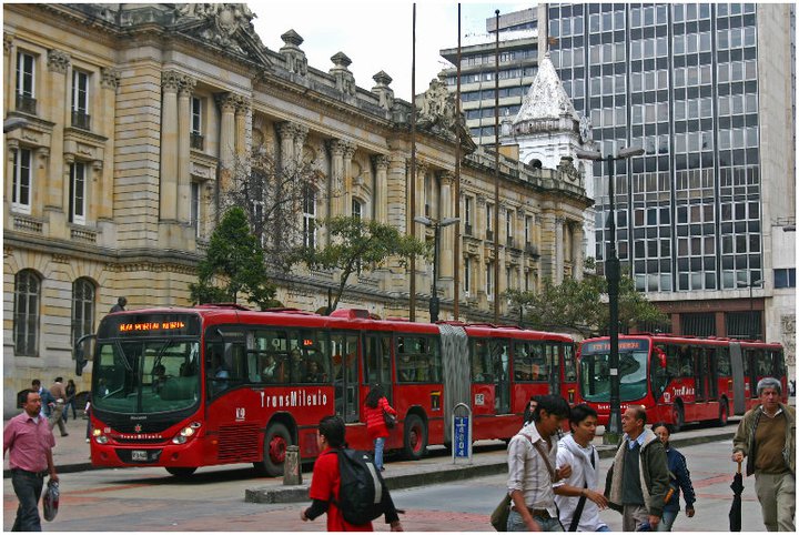
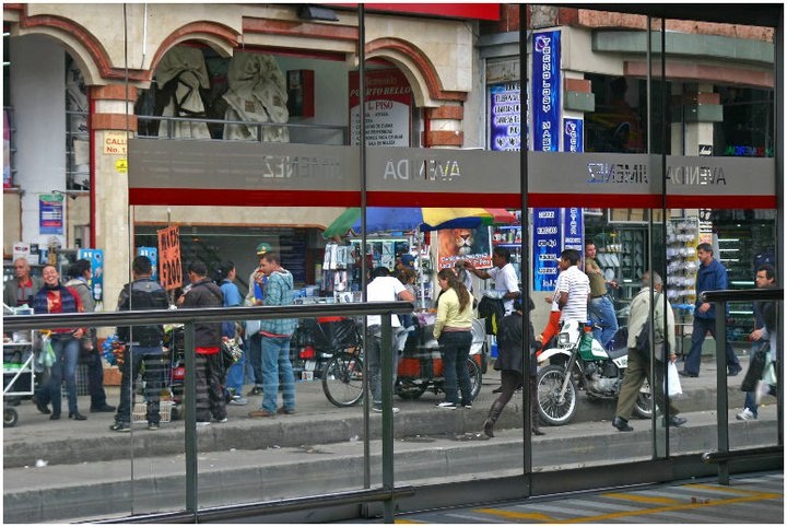
TransMilenio BRT service in downtown Bogota along Calle 13 [LEFT]. Service doors at Avenida Jimeniz TransMilenio Estacion in downtown Bogota [RIGHT]. Photographs by Randy A. Simes.

Operations
The TransMilenio may be one of the most sophisticated BRT systems in the world. During peak travel times, buses operate at extreme frequencies with buses arriving at station platforms virtually non-stop. The buses also receive traffic light priority. They are not timed with lights due to the unpredictability of station length stops as passengers try to cram on the bus.

The system operates from 5am to 11pm and uses an electronic fare payment system. This payment system is different from others systems around the world. Riders purchase a specific number of trips from a person staffing each location. This creates backups during heavy travel times as many people attempt to purchase trip cards. These cards are then used until the last trip when the card is inserted into the turnstile and recycled for later use.

Fares have risen steadily since the system began operation in late 2000, and now costs 1,700 Colombian Pesos per trip (about $1). The huge ridership numbers clearly allow for fares to be kept low, but the rising cost of oil is sure to impact a system that relies solely on diesel fuel.

The buses are all managed at a central dispatch center which tracks average travel speeds, stacking at stations and other schematics. This system tracking allows operators to determine how future improvements should be made, and how operation changes can improve service.

Conclusion
Cincinnati should learn from Bogota’s experience. The TransMilenio offers superior service, but also suffers from problems that could be solved with a greater upfront investment.

When operating lots of big buses at high frequencies, it is no wonder that heavy pollution comes with it. Bus rapid transit in Cincinnati should utilize electric overhead wires, or some sort of clean fuel technology to prevent such pollution from proliferating along the lines.

When designing bus rapid transit lines and stations for Cincinnati, city leaders and transit officials should not view BRT as a cheap transit alternative. In the case of BRT, like many things, you get what you pay for. The TransMilenio has robust stations and huge amounts of right-of-way clearly separated from other traffic. BRT systems that do not invest in superior station designs and separated right-of-way, will suffer lower ridership due to the lack of improved travel times and overall perception problems.

Bus rapid transit should also not be viewed as a transit solution to be done instead of rail investments. This has been seen in Bogota, and city leaders there are now working on a new subway and a massive light rail system that will compliment the TransMilenio which will eventually cover 241 miles.

Categories
News Transportation

Local transit map exceeds expectations

In less than six months, Nate Wessel has helped bring change to Cincinnati’s transit system. After debuting his bus-riding basics map on UrbanCincy earlier this year, Wessel launched the project on crowdfunding site Kickstarter in April. People from Cincinnati and around the world responded to the design, and in 30 days the initiative had raised twice its initial goal of $1,000.

In five days, the Transit Guide raised over $1,200. By the deadline, over one hundred donors had given $2,105 to help print and distribute the pocket guide to bus riders all over Cincinnati.

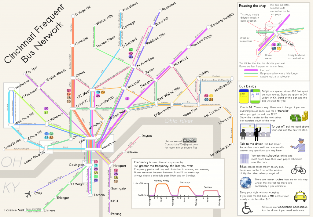
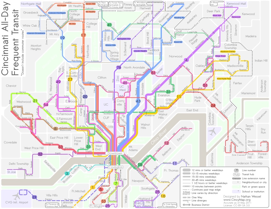
Wessel also had an opportunity to interface with donors and solicit feedback on the map’s design during the fundraising period, and the updated version is better than ever. Described as a diagrammatic illustration of the Greater Cincinnati area’s transit system, the guide shows conceptually where, when, and how one can travel by bus.

It’s nearer to New York City’s Subway Map or that of London’s Tube in design than to the more literal and more difficult to read maps of most Midwestern cities like Akron or Cincinnati.

Like the New York map, his new map for Cincinnati highlights the important frequent and convenient transit lines over services that are infrequent, specialized or too complex to readily apprehend. Lines are spaced for easier reading, and line thickness indicates how long one can expect to wait for the next bus. The most frequent lines have buses that come every ten minutes in each direction for most of the day. The thinnest lines have service every 1 hour or slightly better.

The map does not include routes that only run during rush hours to serve commuters, since these have a relatively limited application. The back of the map will answer some common questions for people who have never been on the bus before, point out peculiarities of specific lines and highlight major routes and bus stops in Downtown.

The funds from the project will be used to print and distribute more than 30,000 pocket-sized copies of the map and several hundred posters to organizations and businesses in the area.

“I particularly hope to get maps in the hands of students, young professionals and recent immigrants and visitors to Cincinnati,” said Wessel. “As it is, people who are new to the city, or just unfamiliar with the transit system face an enormous hurdle in trying transit for the first time.”

He believes many in the city would utilize the bus service if they understood it better – where and when the buses go. The local transit authorities have tried, but not completely succeeded in making their maps user-friendly.

Wessel admits the current transit system is not perfect, but it is pretty good. “My goal is to allow people to see what good service exists, and where it can take them,” he explained. “This way users can better understand the system that serves them and to begin to see public transit as a realistic transportation option.”

Nate will be giving a talk at the Contemporary Arts Center on May 23rd to further explain the project.

Updated Cincinnati Transit Guide map provided for UrbanCincy by Nate Wessel.

Categories
News Transportation

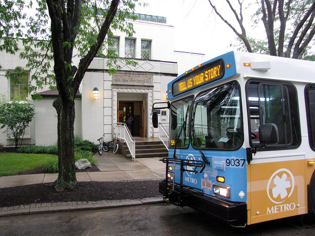
Metro officials looking for feedback on preliminary Google Transit interface

UrbanCincy has been contacted by thousands upon thousands of Cincinnatians clamoring for Google Transit to come to Cincinnati. Virtually every bus-related story published on UrbanCincy over the past three years has included at least one comment expressing this desire.

Those who ride buses operated by the Transit Authority of Northern Kentucky (TANK) have had the pleasure to use this intuitive transit planning system for some time, and most major transit systems around the country also are included. In Cincinnati, however, the Southwest Ohio Regional Transit Authority (SORTA) has had difficulty working with Google officials in sharing data and getting the system functional for the region’s largest transit operator.

Cincinnati bus riders rejoice over Google Transit announcement

SORTA is currently working with Google and is in a testing phase for the transit mapping system, and they would like Metro bus riders to provide feedback to ensure that the service is working correctly before it goes live to the public.

Those interested in testing it out, and providing feedback, can do so by visiting Google Transit and simply entering in a beginning and end destination which you would like to travel by bus. The mapping system works exactly the same way as directions on Google Maps.

Once you give it a test drive, you can then provide feedback to SORTA by emailing MyMetroStory@go-Metro.com, or by taking their short online survey. SORTA officials are asking that feedback be as specific as possible, so when referring to something you noticed, please provide the map URL and describe the error or positive result you received.

Those who contribute before Friday, May 6 will then be entered into a drawing where three randomly selected individuals will receive gift certificates for a month of free rides on Metro. Once testing is complete, SORTA officials hope to promote Metro on Google Transit to the public this summer.

Categories
Development News Transportation

Guangzhou’s bus rapid transit system wins city international transport award

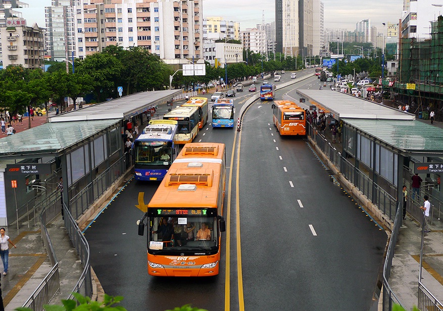
Streetfilms, in partnership with the Institute for Transportation & Development Policy (ITDP), produced a new video highlighting Guangzhou’s bus rapid transit (BRT) system. The BRT system won the city the 2011 International Sustainable Transportation Award from ITDP, and currently serves 800,000 passengers each day.

The system is by far the largest BRT system in Asia, but comes in behind Bogota’s Transmilenio system which serves 1.2 million riders daily. The similarities are striking though. Both Guangzhou and Bogota include robust stations and heavily dedicate right-of-way. The systems are also being built in combination with other forms of transport instead of lieu of them.

“You must also think about multi modal integration,” says Xiaomei Duan, Chief Engineer, Guangzhou BRT Project. “For example, on this corridor we have three metro stations integrated with our BRT station, and around the BRT stations we have our bike stations.”

Guangzhou is the second largest city in the world with approximately 25 million people, and it is one of the fastest growing cities in the world. The implementation of the new BRT system was done, in part, to cut carbon emissions, reclaim space for people and reduce traffic congestion.

The Guangzhou BRT system opened in February 2010 and was designed to now be completely integrated with the city’s new bike share network and metro system.

Categories
News Politics Transportation

Transit ridership increases in Cincinnati as gas prices rise

A struggling job market led to ridership declines for Cincinnati’s primary transit operator over the past two years, but new data shows ridership growth for the Southwest Ohio Regional Transit Authority (SORTA).

SORTA operates Metro bus service and will be the operator of the Cincinnati Streetcar when it becomes operational in 2013. Beyond improving economics, Metro officials believe that soaring gas prices are a big reason for the ridership growth.

Metro saw ridership increases in both January and February which saw a five percent ridership increase over the previous year.

The positive news comes with continuing negative news from Columbus for Metro’s 17  million annual riders. While Metro posts ridership gains and experience an improving bottom line, they are also seeing state funds dry up at the request of Governor John Kasich (R).

Since taking office, Kasich has given away a $400 million federal investment in high speed rail that would have connected Cincinnati, Dayton, Columbus and Cleveland. The governor has also cut transit funding by $70 million which led to the elimination of express bus service from Cincinnati’s northern and western suburbs to Uptown, and he appears poised to try to yank $52 million from the Cincinnati Streetcar project.

“We believe Metro’s ridership increase is a response to the high gas prices, and Metro serves the community by providing a money-saving alternative,” Terry Garcia Crews, Metro CEO, said in a prepared release.

But as gas prices continue to rise, and more people look for money-saving transportation alternatives, they may be greeted by fewer options. Those interested in riding Metro can purchase unlimited monthly passes for $70 or single trips for $1.75.