Categories
News Opinion Transportation

EDITORIAL: Cincinnati Should Embrace John Cranley’s Residential Parking Permit Idea

We subsidize parking for automobiles in almost all situations in our society, but it is especially true when it comes to public parking. This can be seen quite clearly throughout the city where public parking garages, lots and on-street spaces are regularly priced below market rates.

A recent proposal by Cincinnati Mayor John Cranley (D) to charge $300 annually for a residential parking permit in Over-the-Rhine was met with immediate criticism. Perhaps the criticism was fair given that such a rate would be the highest in the country by a long shot. And yes, that includes far higher than what’s charged in San Francisco, Washington D.C. and New York.

UrbanCincy, however, believes this says more about the sad state of subsidizing parking than anything else. In fact, we believe that the $300 annual parking permit is reasonable.

To better understand how this proposed permit fee stacks up, let’s consider that it averages out to approximately $25 per month. According to the most recent State of Downtown report, the average monthly parking rate in the Central Business District, Over-the-Rhine and Pendleton is $89. This average accounts for approximately 36,400 monthly parking spaces available in 2013.

While this average monthly parking rate is skewed by much higher rates in the Central Business District, many lots and garages reserved for residential parking in Over-the-Rhine charge between $40 and $110 per month. This means that Mayor Cranley’s proposal would put the city’s on-street parking spaces nearly in-line with their private counterparts.

This is a smart move. We should stop subsidizing parking as much as possible. Therefore, such a proposal should not only be examined in greater depth for Over-the-Rhine, but all of Cincinnati’s 52 neighborhoods.

According to parking management policy expert and UCLA professor Donald Shoup, charging market rate prices is particularly important for a variety of reasons. One of the primary reasons, however, is the fact that the higher prices will cause higher turnover and thus positively influence a number of other factors such as reduced congestion from cars circling the block and reduced pollution from those cars’ exhaust.

UrbanCincy recommends identifying what the market rate for parking is throughout the city and establish districts where on-street residential parking permits can be purchased. The proceeds from those permits could then be reinvested back into those neighborhoods for improvements of selected by those neighborhoods.

In Over-the-Rhine it has been suggested that the money could go toward offsetting the operating costs of the first phase of the Cincinnati Streetcar, but in other neighborhoods it could support public art, cleanup activities, public art or whatever it is that neighborhood desires.

This may not have been what the mayor had in mind when first proposing the residential parking permits for Over-the-Rhine, but if it was then Mayor Cranley deserves serious kudos.

Categories
Business Development News

Second Phase of Newport on the Levee to Come More Than 15 Years After First

Newport on the Levee was the talk of the town in the late 1990s. It was to be one of the most prominent development projects in the urban core for some time, and transform Newport’s riverfront into a place that would attract tourists year-round.

There were also lofty visions that the development of Newport on the Levee would spark a wholesale redevelopment of the Northern Kentucky river city, including virtually every neighboring property and the development of the 1,000-foot-tall Millennium Tower.

These ambitions, however, were never fully realized. Newport on the Levee experienced a number a setbacks and never fully embraced the mixed-use nature that would ensure its success, Millennium Tower was cancelled almost as quickly as it was proposed, and while surrounding development has taken place, it has come at a much slower pace than envisioned.

Earlier this month developers took the next step forward with a plan to build on the long vacant Lot B next to the Purple People Bridge that would aim to address those issues.

According to Capital Investment Group (CIG), the investment would total $80 million and add 238 residential units, 8,000 square feet of street-level retail space, a 150-room hotel and an 800-space parking garage.

Newport city officials and CIG representatives say they intend to start construction in July 2015 and wrap-up a year later.

While this is good news for Newport on the Levee, it is certainly not when or how developers and city officials had originally envisioned the riverfront development taking shape.

In 2000, the plan was for Newport on the Levee to include a mall with a movie theater complex, an aquarium, a state-of-the-art 3-D IMAX theater, and a second phase of development that would begin just two years later and be anchored by a 200-room hotel.

Problems arose almost immediately when the 3-D IMAX shut down just two years after it opened in 2001. The retail portions of the mall also never seemed to live up to expectations, perhaps following in Tower Place Mall’s footsteps and illustrating that enclosed shopping malls tend to not work in urban settings.

As a result, the mall portion of the development has seen a constant cycle of tenants in and out, and more recently the replacement of most retail inside the mall structure by office tenants. Several restaurant operations have even relocated across the river to The Banks development. The former 456-seat IMAX theater has since been filled by the successful Newport Aquarium.

Shortly after the opening of the first phase of work at Newport on the Levee, city officials also pursued the USS Cincinnati submarine in an effort to dock it along the shore of the Ohio River next to Newport on the Levee. Those plans never materialized and now only a portion of the submarine vessel will be returning to the region – at a location in a future phase of Smale Riverfront Park along Cincinnati’s riverfront.

During all of this Newport Aquarium has been a particularly bright spot for the development. It is consistently named one of the nation’s best aquariums and is a constant draw for tourists and locals alike – attracting more than 11 million visitors since it opened 15 years ago.

With the Great Recession now in the past and new competition from The Banks, Newport officials and developers are looking to jump start things once more. The second phase of Newport on the Levee may be more than a decade behind schedule, but it will add a critical component that was sorely missing from the original development.

Full-time residents and a hotel at the site will help drive more business to shops and restaurants operating outside of the typical weekend hours popular for tourists. The revived talk of extending the streetcar system across the river also shows a new sense of collaboration and possibility that did not exist in the lead up to the new millennium.

Categories
News Transportation

Will Main Street Follow in Vine Street’s Footsteps and Return to Two-Way Traffic?

City and community leaders are taking a fresh look at some of Over-the-Rhine’s streets and intersections to see if they might be able to better function if managed differently.

In the 1940’s many downtown streets were converted from two-way to one-way traffic in order to stream automobile traffic through the city center. With the completion of Interstate 75 in the late 1950’s and Interstate 71 in the late 1960’s, some of these streets became important feeders into the highway system.

Additionally, many north-south streets, such as Main, Walnut and Vine, remained one-way to help move traffic throughout the new auto-oriented street system.

It eventually became clear, however, that one-way streets were not adding much benefit beyond moving vehicles slightly faster on their way to and from the interstate highways.

As a result, the City of Cincinnati spent around $400,000 in 1999 to convert Vine Street back to two-way travel from Central Parkway to McMicken Avenue. A subsequent study in 2004 found that traffic along Vine Street became slightly more congested, but also reduced the speed of motorists traveling through the historic neighborhood.

Since its conversion, Vine Street has also blossomed with dozens of new businesses, which can, in part, be attributed to slower traffic and improved access and visibility. As a result, there have been several other examples of this type of conversion throughout Over-the-Rhine, including sections of Thirteenth and Fourteenth Streets.

Two-way street conversions are typically credited with improving safety for pedestrians and cyclists, while also helping local businesses along the street by making it easier for drivers to navigate city streets. In addition to that, a civil engineer from Penn State University even found that the conversion of one-way streets can even improve traffic flow.

“Two-way networks can serve more trips per unit time than one-way networks when average trip lengths are short,” Dr. Vikash Gayah wrote in his essay. “This study also found that two-way networks in which left-turn movements were banned at intersection could always serve trips at a higher rate than one-way networks could, even long trips.”

Gayah’s conclusion was that the trip-serving capacity of a street network can actually be improved when converted to two-way operations, and when left turns are banned.

“This framework can be used by planners and engineers to determine how much a network’s capacity changes after a conversion, and also to unveil superior conversion options,” Gayah noted.

In Cincinnati, initiating such conversions can come in the form of streetscaping projects or through formal requests made by neighborhood leaders. From there, City engineers will determine the feasibility of suggested conversions. In some cases, like E. Twelfth, E. Thirteenth, Fourteenth Streets, City engineers have said that the streets are too narrow to be converted and remain one-way to allow for on-street parking.

The Over-the-Rhine Community Council recently submitted a request to the City to convert Main Street back to two-way traffic.

“At most times of the day Main Street has relatively light traffic and motorists speed down the street in order to make every green light,” Seth Maney, head of Main Street OTR, explained to UrbanCincy. “It can seem more like a drag strip than a pedestrian-oriented business district.”

The specific request from Over-the-Rhine activists is to convert both Main Street and Walnut Street. However, transportation officials say that the routing of the first phase of the Cincinnati Streetcar will prohibit such a conversion south of Twelfth Street.

“The streetcar route is something we have to consider if there was a desire to convert the north-south streets to two way traffic.” said Michael Moore, Director of Cincinnati’s Department of Transportation & Engineering (DOTE). “The conversion from Twelfth to Liberty Street, however, would be relatively simple.”

In addition to Twelfth Street, the streetcar’s routing along Elm and Race would also seem to make it improbable that either of those streets could be converted to two-way traffic.

Categories
Development News Opinion

Delay Presents Opportunity for 3CDC to Rethink 15th and Race Development

Between two of Over-the-Rhine’s most treasured attractions is a Cincinnati Center City Development Corporation (3CDC) proposal currently on hold. As a result, the non-profit development corporation will either need to obtain a new funding source or the project will need to be “a little more within the scale of the existing market.”

The current proposal for the mixed-use project at Fifteenth and Race includes over 300 parking spaces, 57 residential units, and almost 22,000 square feet of commercial space. With the project now on hold, now is the time to step back and critically evaluate a major development in the heart of Over-the-Rhine.

The unnamed development sits primarily along Fifteenth Street, between Pleasant and Race Streets, and would occupy almost an entire city block with a massive parking garage and what can otherwise be described as a lackluster design. Think Mercer Commons 2.0.

Stand at the northern edge of Washington Park and look down Pleasant Street. If your eyes are better than mine, you’ll see Findlay Market. If you’d like to walk there, it is only a leisurely five to ten minute stroll. This proposed development’s car-centric design places a parking garage exit on Fifteenth Street, and would force vehicular traffic onto one of Over-the-Rhine’s most important pedestrian axes.

Additionally, the garage packs in 200 more vehicles than is mandated by law, forces the partial demolition of two historic structures, and limits the available commercial and residential space sandwiched between the phase one Cincinnati Streetcar route. If the streetcar should increase property value as predicted, a parking garage may not be the best use of land for such a prominent location along the line.

As is currently designed, the buildings that would wrap the garage present themselves as a homogeneous wall. This character contrasts heavily with the existing fabric that presents gaps between buildings, portals to interior courtyards, and strong visual relief. While the roof line makes an attempt at creating rhythm in concert with windows, its variation is not enough to mask that it is one big building.

These characteristics detract from the pedestrian scale, though the new construction hints at these qualities with balconies, recessed entries, and slightly offset building faces. These expressions are more akin to developments at The Banks and U Square at The Loop, and are a cheap imitation of Over-the-Rhine’s authenticity.

Along Pleasant Street, the Fifteenth and Race townhomes are compressed by the large, central parking garage. The private walk at the townhomes’ rear is noted as a ‘garden space’ but these spaces are approximately 10 feet wide and will be shadowed by a three-and-a-half-story parking garage. Along the street, the crosses and boxes highlighting the townhomes’ windows are wholly contemporary, which are expressions out of place on a building that is neither modern nor traditional; it is non-committal.

It should be noted that an entire block design is a difficult task in Over-the-Rhine because its designation as a historic district stems from the collection of smaller individual buildings built over time. Furthermore, the neighborhood’s historic character, established before the invention of the automobile, does not easily accommodate cars.

However, there will be a need for more parking, and the Over-the-Rhine Comprehensive Plan recognizes this, but states that new parking should be done “without impacting the urban fabric or historic character of the neighborhood.”

Individually rehabbed buildings do not typically have the potential to alter a neighborhood’s character, but when large-scale development is proposed, community members should have a place at the table.

When asked about developers engaging community stakeholders, Steve Hampton, Executive Director of the Brewery District Community Urban Redevelopment Corporation, says, “If there’s one place for community outreach it is in large-scale development because of the unique architecture, historic neighborhood, and diversity of people in Over-the-Rhine.”

In the case of this Fifteenth and Race development, the first stages of community engagement were initiated by Over-the-Rhine Community Housing (OTRCH) and Schickel Design, who completed the Pleasant Street Vision Study (PSVS) in 2013.

While the proposed development incorporates all of the individual elements from the PSVS, it is not in the spirit of the pedestrian-focused Pleasant Street Vision Study and on a very different scale. The size and location of the parking garage is a major difference between the 3CDC proposal and the PSVS, and Mary Rivers, of OTRCH, noted that this is a big issue for many people.

Of course there is a gap between a vision study that outlines a community’s desires or needs, and the market forces that drive a real development, but there are various ways a community should be engaged in a project of this scale.

While OTRCH held focus groups prior to beginning the award-winning City Home project one block south along Pleasant Street, Rivers said that 3CDC did not engage OTRCH until after the current plans had been unveiled.

Rivers said, “We asked a diversity of people, ‘What do you like in Over-the-Rhine? What are you looking for in a home?’ Their answers ultimately influenced the design.” This type of engagement is not easy; and Rivers acknowledged that the best way to engage a community is on big issues not the details.

3CDC needs to step up, engage community stakeholders, and propose a design that is more respectful to Over-the-Rhine’s residents, and its unique architectural and urban form.

Categories
Business News

REPORT: Cincinnati Region Failing at Developing Walkable Urban Places

U.S. Metropolitan Land Use OptionsA recently released report conducted by The George Washington University’s Center for Real Estate & Urban Analysis in conjunction with LOCUS: Responsible Real Estate Developers and Investors, a coalition of Smart Growth America gave the Cincinnati region low marks for its walkability and growth patterns overall.

The report, entitled Foot Traffic Ahead, attempts to quantify the seemingly surging movement of people back into cities with a desire for walkable places.

The idea is that developers, investors, government regulators and financiers understood the model that successfully built America’s suburbs during the second half of the 20th century, but that a new model is needed with that era now behind us.

“Over the next generation, walkable urban development will spur even greater economic growth as demand for walkable urban development is met. The future growth of walkable urban places could provide the same economic base in the 21st century that drivable sub-urbanism did in the mid- to late-20th century. However, this growth will not be realized without appropriate infrastructure, zoning, and financing mechanisms at the federal, state, and local levels.”

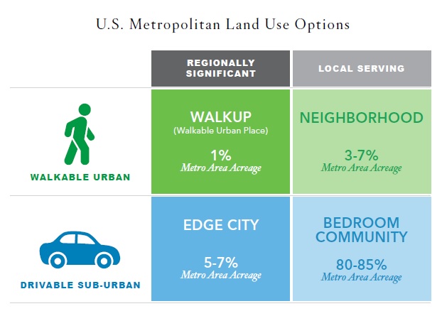
Therefore, the authors of the report, in coordination with a Brookings Institution methodology developed in 2012, defined two primary forms of land use: drivable sub-urban and walkable urban. They also defined the two primary economic functions of those forms as being either regionally significant or local-serving.

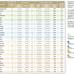
Of the four potential combinations of these forms and functions, Foot Traffic Ahead focused on the regionally significant walkable urban places (WalkUPs) in each of the nation’s 30 largest metropolitan regions. When considering all of this, the authors of the report identified 558 WalkUPs nationwide, with 66 of those located in the New York City metropolitan area alone.

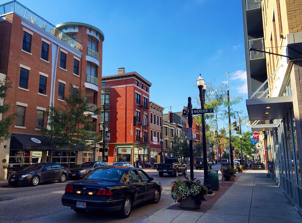
Out of the 30 regions studied, Cincinnati was ranked 20th with seven total WalkUPs in the region. Those seven WalkUPs, the report found, contained 33,234,000 square feet of office and retail space, or approximately 15% of the region’s total.

When compared with other regions, an astonishing 100% of the office and retail space located within WalkUPs were within the central city. What this means is that while Cincinnati’s urban core is extremely walkable, virtually nothing outside of it is. As a result, Cincinnati fell at the low end of the six regions classified as ‘Tentative Walkable Urbanism’.

“Four of these six metros – Houston, Columbus, Kansas City and Cincinnati – have 93% or more of their walkable urban office and retail space in the central city; virtually no walkable urbanism exists in their suburbs,” the report noted. “These four metros continued the expansion of drivable sub-urban development patterns.”

It is worth repeating that the methodology of this analysis places a priority on regionally significant places that contain at least 1.4 million square feet of office space, 340,000 square feet of retail space and a Walk Score value of at least 70 points throughout 100% of its area.

Such requirements penalize smaller and mid-size metropolitan regions that have less of this space overall. Perhaps illustrating this is the fact that while Cincinnati ranks 20th overall in this ranking, it comes in at 15th overall in terms of its number of WalkUPs per capita. Had the threshold for defining WalkUPs been lower, then perhaps more areas could have been considered into the overall WalkUP calculations for the region, and thus included smaller hubs outside of the central city.

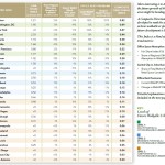
When compared with the other regions, the future looks even grimmer for Cincinnati. In that ranking, Cincinnati falls five spots and into the category of ‘Low Potential for Future Walkable Urbanism’.

As is true with the existing rankings, the future rankings place a high significance on high volumes of real estate development. With regional growth rates hovering around 0.4%, it offers little opportunity for a region like Cincinnati to make dramatic changes to its development footprint.

However, when compared with the other regions, Cincinnati also appears to be lagging in terms of developing a robust regional transit system with both bus and rail, and lacks regional coordination on developing walkable urban developments. The report did however note that Cincinnati’s streetcar system currently under-construction serves as a bright spot that alone may shift the region from the ‘Low’ to ‘Moderate Potential’ category.

“These 13 metropolitan areas continue to lose market share in office and retail locating in their WalkUPs, continuing the mid- to late-20th century trend toward drivable sub-urbanism,” the report concluded about the regions with low potential in their future rankings.

Walkable Urbanism and GDP Performance Walkable Urbanism and Educational Attainment Education and GDP Performance

“In addition, they do not have substantial office rental price premiums. With 5% to 13% of office and retail space in WalkUPs, these metro areas have a long way to go to fully develop walkable urbanism.”

The real interest in the report, however, comes with its overall findings and correlations, as that is where the dire future outcomes may lie for the Cincinnati region.

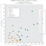
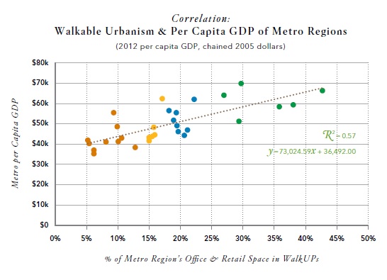
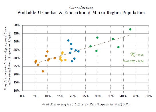
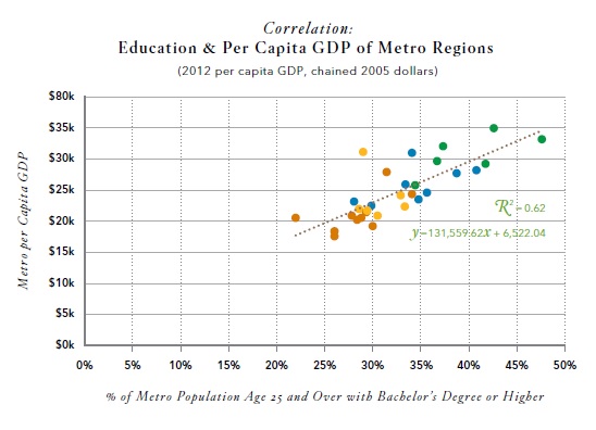
In the report it found that regions with more walkable urbanism also had higher GDP performance, and that those same regions tended to have higher educational attainment.

“Given the relationship between educational attainment and walkable urbanism, and the relationship between educational attainment and per capita GDP, it is not surprising that walkable urbanism and per capita GDP are also positively correlated.”

According to the report, the six highest-ranked regions have a per capita GDP approximately 38% higher than the 10 lowest-ranked regions.

Of course, these findings alone cannot indicate whether walkable urbanism causes highly educated persons to move or stay away from certain regions, or whether places become more walkable due to there being more highly educated people there. But the correlations are strong enough that it is something that should make regional business and political leaders rethink the way in which Cincinnati develops.

“Although more research needs to be done to understand why walkable urbanism is correlated with higher per capita GDPs and education levels, this evidence suggests that encouraging walkable urbanism is a potential strategy for regional economic development.”