Categories
Business Development News Politics

Inner-City Neighborhoods Center of Population, Economic Power in Cincinnati Region

The Cincinnati region has been one of the nation’s best economic performers over the past several years, and that has resulted in a 6.4% unemployment rate that is more than a point better the national average.

According to the U.S. Census, more than 968,000 jobs are scattered all over the region, but it is the City of Cincinnati that stands out as the dominant force for the 2.1 million person region.

As the numbers in the City of Cincinnati’s 2013/2014 Biennial Budget Report show, the financial standing of the central business district is critically important to the overall financial health of the entire city and county. According to the report, income taxes brought in $234 million last year – nearly 71% of the City’s total revenue in 2012.

Cincinnati Employment Density Cincinnati Employment/Population Share
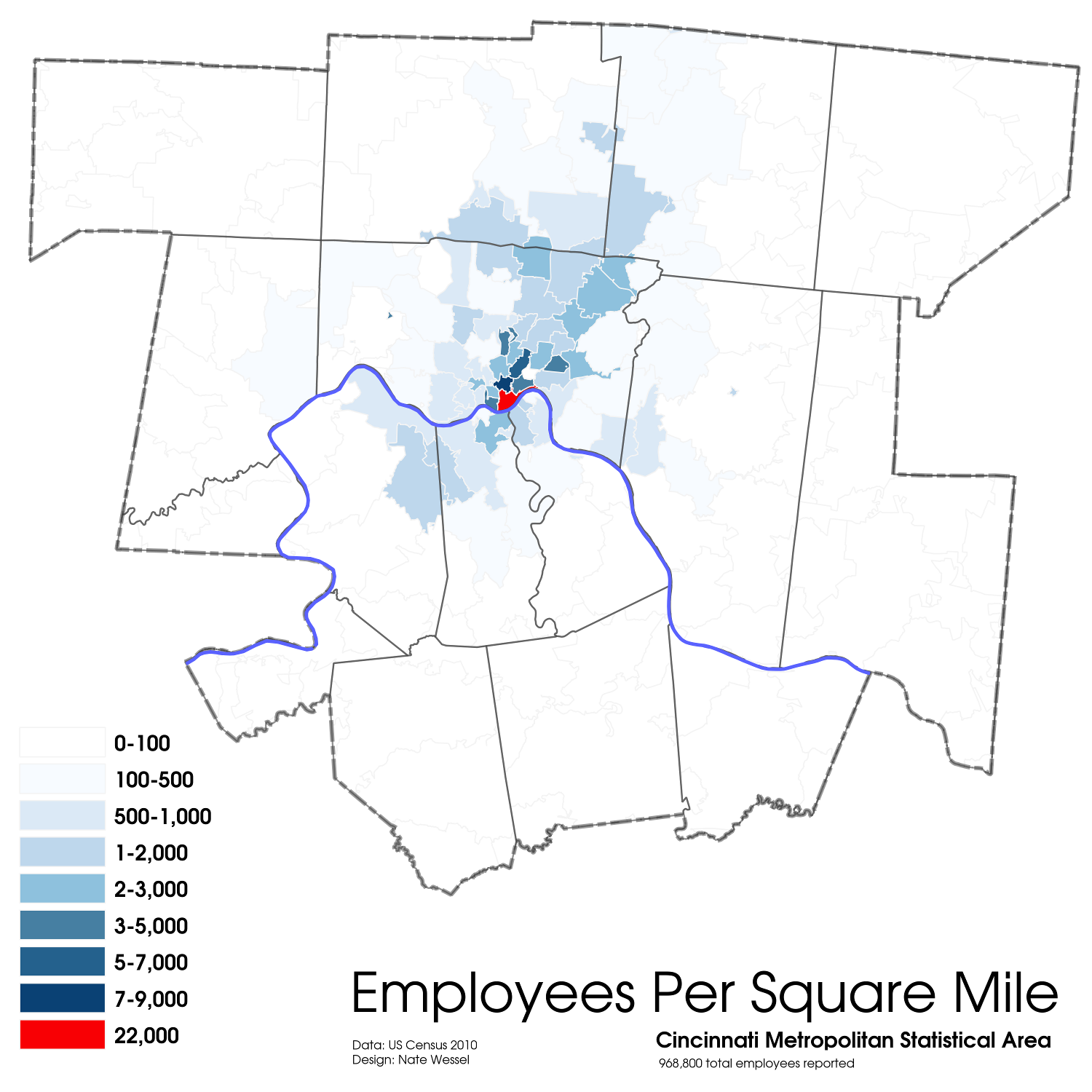
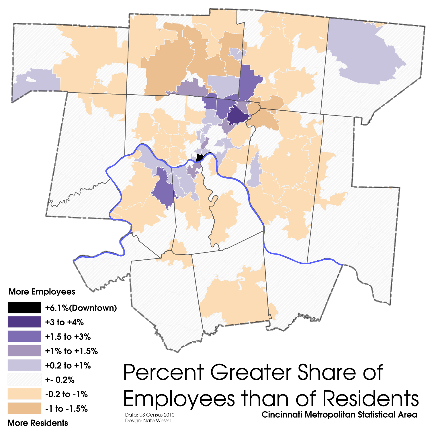
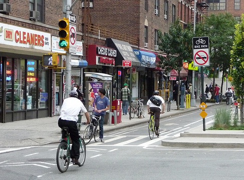
While outlying suburban communities have seen an influx of jobs over the past 30 years, Downtown and Uptown remain the region’s preeminent job centers. Employment Density Map and Employment/Population Share Map by Nate Wessel for UrbanCincy.

In the Cincinnati Metropolitan Statistical Area (MSA), center city neighborhoods account for the highest concentration of jobs, with more than 22,000 jobs per square mile in Downtown’s 45202 zip code, and anywhere from 3,000 to 9,000 jobs per square mile in Uptown neighborhoods.

“Downtown and Uptown are the City’s largest employment centers and therefore they are very important to the City’s financial health,” said Lea Ericksen, Cincinnati’s Budget Director. “We want all our neighborhoods to improve tax earnings by increasing residents, jobs and overall economic vitality, but we are focused on the six GO Cincinnati strategy areas for redevelopment.”

Cincinnati’s 2.1% income tax largely goes to support the General Fund which pays for operating expenses like police officers and fire fighters. Smaller percentages also go to pay for public transit operated by the Southwest Ohio Regional Transit Authority (SORTA) and capital investments in City buildings and infrastructure.

Ericksen projects that while income taxes will remain the same, they will grow in value by approximately 2.6% annually over the next six years.

Income & Property Tax Earnings (2004-2016)
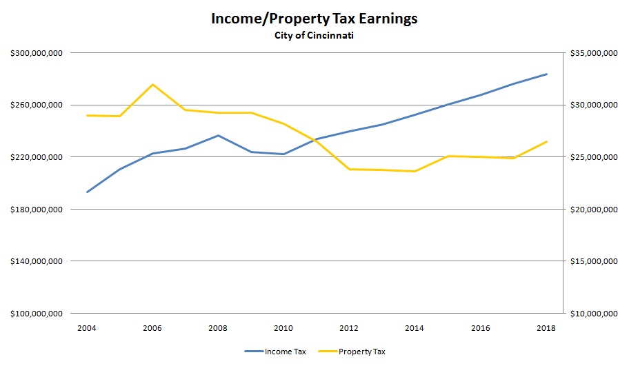
The City of Cincinnati has experienced steady growth in income tax revenues since 2004, but it has struggled to recover from the previous decade’s housing crash. Chart produced by UrbanCincy.

Property taxes are the next largest revenue generator for City Hall – accounting for $23.9 million in 2012. City officials expect this number remain stable over the next four years following an initial $7.8 million annual bump should the current property tax rollback be eliminated and set at 6.1 mils.

Like the clustering of jobs in the city’s urban core, the most heavily populated neighborhoods are also located within the center of the region.

“People are very interested in center cities, and we have an exceptionally attractive center city,” David Ginsburg, President/CEO of Downtown Cincinnati Inc. told UrbanCincy. “The architecture here and the geography that we have being in the valley. We just have a compact, spectacular downtown, and I think we have barely touched the surface of what the market can bear.”

Some of the most valuable residences are located along the central riverfront and eastside neighborhoods, with recent growth in northern communities in Butler and Warren Counties.

Cincinnati Population Density
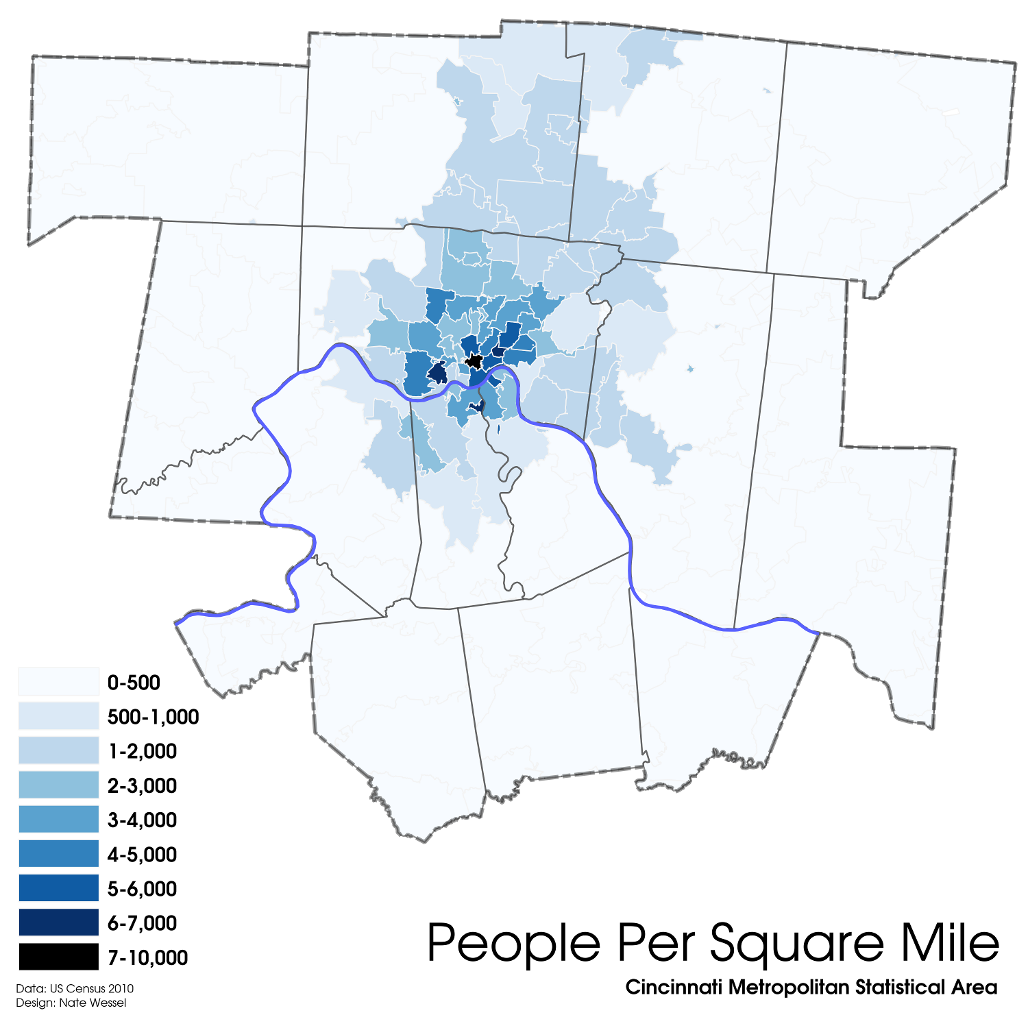
Several neighborhoods boast densities of 7,000 or more people per square mile, and those neighborhoods are all centrally located. Population Density Map by Nate Wessel for UrbanCincy.

Uptown neighborhoods surrounding the University of Cincinnati and Xavier University, Downtown/Over-the-Rhine, and close-in neighborhoods on the westside and along the Northern Kentucky riverfront are the most densely populated in the region.

“We’ve seen quite a bit of where we rehab a home, the neighbor decides to rehab their home,” Ken Smith, Executive Director of Price Hill Will, said about the development corporation’s Buy-Improve-Sell program which has rehabilitated 52 thus far in 30,000-person neighborhood, on episode 14 of The UrbanCincy Podcast. “People are very impressed with the housing stock in the neighborhood, and they are often quite impressed.”

Not all is well, though, for city leaders as they attempt to recover from the housing crash that took place between 2006 and 2010. Neighborhoods like East and West Price Hill are aggressively working to improve their residential housing stock by getting rid of vacant units even by taking advantage of hundreds of demolitions planned throughout the city.

“We are working with the Hamilton County Land Bank to get these empty lots into hands of those next door, but there are going to be a few houses that I wish we could save, and in better times maybe we would have the money to save it, but in better times they may not have gotten to that point,” explained Price Hill Will’s Matt Strauss, Director of Marketing & Neighborhood Promotion at Price Hill Will. “The goal is not only to bolster owner occupancy, but to increase property values in the neighborhood.”

Listen to episode 14 of The UrbanCincy Podcast with the leaders at Price Hill Will to hear more about the work being done on the westside to recover from the housing crash, and episode 15 with David Ginsburg to get the latest insight on the region’s economic engine. You can stream our podcasts online or subscribe to our bi-weekly podcast on iTunes for free.

Categories
News Transportation

City officials working to get Central Parkway back on [cycle] track

There had been hopes to build the region’s first cycle track, a fully separated bicycle facility, on Central Parkway in 2012. Internal disputes and the lack of funding, however, have delayed the project’s implementation.

The Department of Transportation & Engineering (DOTE) gave City Council’s Major Transportation and Infrastructure Projects Subcommittee an update on the project, in addition to the other bicycle investments being advanced, last week.

At that meeting, Mel McVay, Senior City Planner with the DOTE, stated that the Central Parkway cycle track efforts were in the preliminary investigation stage, but that there could be some challenges regarding the facility’s relationship to vehicular capacity and on-street parking along the 3.4-mile stretch of roadway.

The full length of the cycle track would extend from Ludlow Avenue, where the City installed the region’s first green bike lanes in November 2012, to Liberty Street in Over-the-Rhine, and would cost approximately $750,000.

Plans for the Central Parkway cycle track first came to light during episode eight of The UrbanCincy Podcast.

The hope now, McVay says, is to finish the preliminary analysis within the next month. Should that analysis show it feasible to finance and construct the Central Parkway cycle track, then design work would begin immediately.

The City’s Bicycle Transportation Program has installed nearly 40 miles of bicycle facilities to-date, with an additional 289.9 miles planned in a citywide bicycle network.

Categories
Development News Transportation

Cincinnati becomes first Ohio city to install green bike lanes

Construction workers installed bright green bike lanes at three conflict points along Ludlow Avenue yesterday. The new green bike lanes are a first for Cincinnati as it continues to work towards making city streets safer for area bicyclists.

According to the National Association of City Transportation Officials (NACTO), experimentations with specially colored bike lanes first took place in the mid-1990s. Then, between 1997 and 1999, the City of Portland worked with the Federal Highway Administration (FHWA) to mark 10 conflict areas with blue coloring and accompanying signage. Since that time, the FHWA has determined that green is a more appropriate color for bike lanes on public streets, so as not to be confused with accessibility parking.


The City of Cincinnati used NACTO’s standard design for a truncated bike lane through an intersection as the basis for its green bike lanes on Ludlow Avenue. The installation makes Cincinnati the first Ohio city with green bike lanes.

Green bike lanes have begun to appear in cities throughout North America in recent years to not only mark areas of conflict, but also delineate entire bike corridors. In the Midwest, Chicago has led the charge using green bike lanes for entire cycle track corridors, bike boxes at traffic signals, and at special conflict points.

According to city officials, Cincinnati’s first application of green bike lanes will mark Ludlow Avenue where it intersects with Old Ludlow Avenue, Central Parkway and a driveway entrance to Cincinnati State (map). City planners also say that there will be additional green bike lanes to come.

“We are considering using green markings where the Gilbert Avenue bike lane will intersect with the right-turn lane into the casino,” explained Department of Transportation & Engineering (DOTE) planner, Melissa McVay.

McVay went on to say that City is using NACTO’s design guidelines and specifications for these projects, and that going forward, green bike lanes will be considered at all high conflict areas where motorists must cross a bicycle path.

The idea behind the green markings is to improve the visibility of bicyclists, and in the process, improving safety.

“In this [Ludlow Avenue] case the green lanes help negotiate cars desiring a right hand turn through a bike lane that continues straight ahead,” said Frank Henson, President, Queen City Bike. “By giving the bicycle lanes a different color, motorists realize that, in making their turn, they are crossing into another travel lane reserved for cyclists, and that they must yield to bicycle traffic in order to complete the turn.”

The City of Cincinnati Bicycle Transportation Program has installed 35.8 miles of bicycle facilities to-date, with an additional 289.9 miles planned in a citywide bicycle network.

And when asked about what could be done to continue to improve safety for Cincinnati-area bicyclists, Henson concluded that, “The best thing the City of Cincinnati can do to improve safety for street cycling is to continue to carry out the Cincinnati Bike Plan, improving the network of bike routes, lanes, trails, and paths in the area. Better education and enforcement of traffic law for both cyclists and motor vehicle operators is also necessary.”

We sat down with Melissa McVay on Episode 8 of The UrbanCincy Podcast to discuss Cincinnati’s bike culture – where we stand, how we got here, and what needs to take place next. You can stream that podcast online for free, or subscribe to The UrbanCincy Podcast on iTunes so that you don’t miss an episode.

Categories
Arts & Entertainment Development Transportation

New time-lapse video captures movement of people and machines in Cincinnati

Friend of UrbanCincy and regular URBANexchange attendee, Andrew Stahlke, has produced a new time-lapse video of Cincinnati.

The video showcases construction work at the $400 million Horseshoe Casino, Little Miami Scenic Trail, Eden Park Overlook, boats on the Ohio River, circus training at Burnett Woods, freight activity at the Queensgate Railyards, construction of the new $66.5 million Waldvogel Viaduct, fans at Great American Ball Park, and many other scenes from around Cincinnati.

Stahlke is currently enrolled in the Masters of Community Planning program at the University of Cincinnati, and originally studied civil engineering at Case Western University.

The video, entitled Paths and Nodes: Cincinnati, attempts to capture the life of the city as people and machines move about, and was shot in early fall 2012. It is a nearly three minutes in length, and features music from Little People.

Categories
Business Development Transportation

Cincinnati City Leaders to Move Forward with Ohio’s First Bike Sharing System

A new study, prepared by Alta Planning + Design, has determined how and where a bicycle sharing system could be implemented in Cincinnati in a way that will compliment its expanding Bicycle Transportation Program.

The recently released report was called for by city leaders in May 2012, and identifies a 35-station, 350-bike system that would be built over two phases in Downtown, Over-the-Rhine, Pendleton, Clifton Heights, Corryville, Clifton, Avondale and the West End.

“We went into this study wanting the public to be a big part of the process. They contributed more than 300 suggestions for stations and cast nearly 2,000 votes,” said Michael Moore, Director of the Department of Transportation & Engineering (DOTE). “Thanks to all their input, this study helps ensure bike share is relevant and useful to the residents and commuters in the downtown neighborhoods.”


Several neighborhoods throughout the city were determined as potential areas to be included in a future Cincinnati bike share system. Map provided by Alta Planning + Design.

City officials also say that locations throughout northern Kentucky’s river cities were also popular, and would make for a logical expansion in the future should system arrangements be achieved.

According to the report, the 35 station locations were identified through public input and through a variety of suitability factors that include population density, percentage of residents between the ages of 20 and 40, employment density, mixture of uses and entertainment destinations, connectivity with existing and planned transit networks, and the terrain in the immediate area.

“In general, there are enough positive indicators to suggest that bike sharing is feasible in Cincinnati,” Alta Planning + Design wrote in the 49-page report. “There are no fatal flaws, although a smaller dependency on visitors and ordinances restricting advertising would need to be overcome to make the system financially viable.”

The financial viability of the project is particularly important in Cincinnati’s case as city officials have determined that a privately owned and operated system would be the best business model for Cincinnati.

Alta Planning + Design estimates that the potential 35-station system, spread throughout Downtown and Uptown, would cost approximately $2 million to construct and nearly $200,000 to operate annually. While user fees are expected to sustain a portion of the annual operating costs, system operators will most likely need a variance to city law to allow for advertising on the stations, as is commonplace for bike sharing systems throughout the world.

     
More than 2,000 responses helped determine public support for potential station locations [LEFT]. The initial system would be built out over two phases in Downtown and Uptown [RIGHT]. Maps provided by Alta Planning + Design.

“As of now we do not intend to invest any public funds in the system, other than in-kind assistance with marketing and station siting,” explained DOTE Senior City Planner Melissa McVay, who recently sat down to discuss Cincinnati’s bike culture on Episode #8 of The UrbanCincy Podcast.

Annual membership fees and hourly rates would be determined by the eventual company selected to operate the system, and would be contingent upon how much money could be raised through advertising and local sponsorships.

In addition to drilling into local details and demographics pertinent to a potential Cincinnati bike sharing system, the feasibility study also compared Cincinnati to other cities throughout North America that have operational bike sharing systems.

Through that analysis it was found that Cincinnati’s system would be smaller than those in Miami, Boston, Washington D.C., Montreal and Toronto, but that it would be larger than systems in San Antonio, Des Moines and Chattanooga. Cincinnati’s system is also anticipated to have a more favorable trip comparison, for the first year of operation, than both Minneapolis and Denver.

The report also estimates that Cincinnati’s system would attract 105,000 trips in its first year of operations, with that growing to 305,000 in year five once both Downtown and Uptown regions are operating, with approximately 25 percent of trips replacing a vehicle trip.

“We want Cincinnatians to be able to incorporate cycling into their daily routine, and a bike share program will help with that,” Moore explained. “Bike share helps introduce citizens to active transportation, it reduces the number of short auto trips in the urban core, and it promotes sustainable transportation options.”

The City of Cincinnati is expected to issue a request for proposals, within the next month, that will call for bids from an operator of the planned system. If all goes according to plan the Midwest’s sixth, and Ohio’s first, bike share system could become functional as early as the operator’s ability to acquire funding.