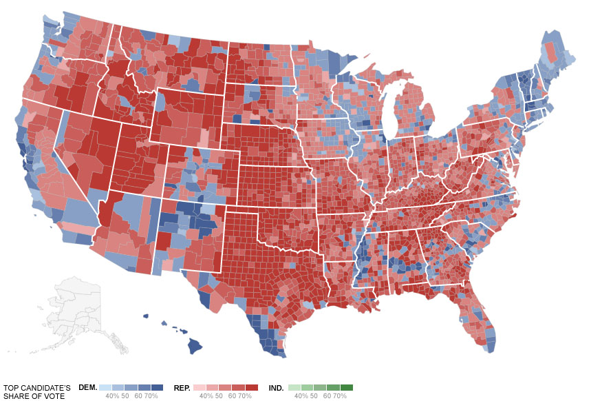
Perhaps unsurprisingly, cities appeared to deliver the victory of a second term for President Obama this election season. According to Edison Research, President Obama earned approximately 69.4% of the vote in cities with more than 500,000 people, and 58.4% of the vote in cities with 50,000 to 500,000 people.
Furthermore, with the exception of Jacksonville and Salt Lake City’s home counties, President Obama won the plurality of votes in every major American city. This includes Cleveland, Columbus, Cincinnati, Toledo, Dayton, Akron and Youngstown in Ohio.
The President Obama won all but two counties with major cities, and swept the major demographics that are changing urban American. Map courtesy of The New York Times.
The browning of America
Cincinnati’s traditionally conservative Hamilton County has been trending more liberal over the past decade. Over that same time frame, American cities have seen a long foreseen demographic shift take root.
In 2012, the U.S. Census Bureau found that minority babies are now a majority of those born in the United States, and that 50,000 Hispanics reach voting age every month. Furthermore, 11% of all U.S. counties are now majority-minority, and half of the 40 largest metropolitan regions now have a while population below 60%.
The trends, when compared with the results of the 2012 election, are profound.
According to NEP Exit Poll conducted by Edison Research, President Obama earned the vote of 92.7% of black voters, 70.6% of Hispanic voters, 73.2% of Asian voters, and 57.7% of all other non-white voters. Mitt Romney, however, did earn the vote of approximately 58.7% of white voters.
Not only are these demographic groups growing in numbers, they are increasingly showing up to vote, with both black and Hispanic voters showing up in record numbers for the second consecutive presidential election.
The single, urban woman
Single women are another increasingly powerful force behind the resurgence of cities. There are an estimated 17 million women who live alone in America, and President Obama won that voting bloc by a whopping 39%.
Sociologist Eric Klinenberg attributes the foundation for this demographic shift to larger cultural changes in American society. In his book, Going Solo, he describes the rapid entry of women into the civilian workforce over the past 40 years, the delay of marriage for young people, and the “divorce revolution” that took place during the 1970s.
In short, young people, especially young women, are much different in contemporary America than those from 50 years ago.
According to the U.S. Census Bureau, the number of women in the workforce has grown from 14.8 million in 1967 to 43.2 million in 2009. And in 2009, it is estimated that approximately 30% of all women over the age of 25 have earned a bachelor’s degree or more.
Should these trends continue, the single urban woman may continue to become an even more powerful voting bloc.
With single women and minorities becoming an increasingly dominant portion of 21st century American cities, it may force the hands both major political parties to focus more of their energy on public policies that positively relate to urban voters.
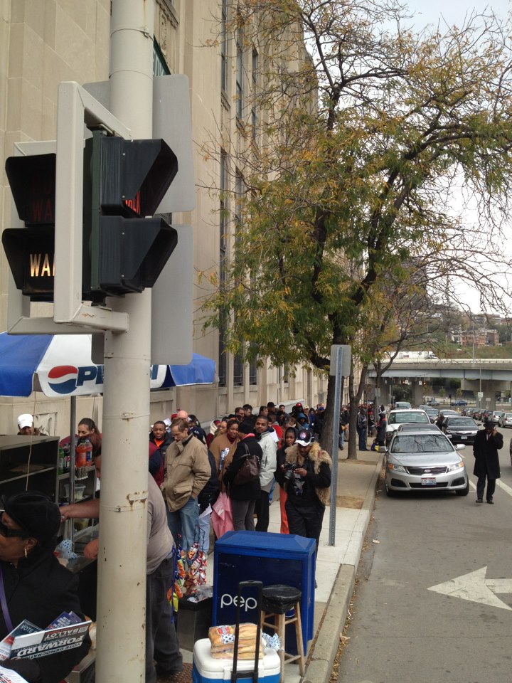
Line for early voting on Saturday, November 3 outside of the Hamilton County Board of Elections. Photograph by David Pepper.
Early voting for this 2012 election season comes to an end today. Those registered to vote, in Hamilton County, will be able to do so by visiting the Board of Elections office at 824 Broadway Street from 8am to 2pm.
According to the Hamilton County Board of Elections, 564,429 people have been registered to vote in Hamilton County – a number slightly higher than that in 2008. The difference between 564,429 voters in 2012, however, is that their early voting days have been greatly reduced.
On top of the reduced number of days to vote early, voters across Ohio are only allowed to cast an early vote at one location per county. This means that voters in heavily populated counties with big cities are subjected to longer waits. So far, voters in Hamilton County have reported up to 4.5-hour-long waits downtown.
Polling numbers show an incredibly tight presidential race that may come down to how Ohio votes on Tuesday. Furthermore, with Hamilton County being the most populated swing county in Ohio, the race for the presidency may end up being decided in Cincinnati. It’s no wonder President Obama (D) held a rally before 13,500 people at the University of Cincinnati last night.
UrbanCincy would like to see all voters offered the opportunity to cast their ballot for every election. It is extremely unfortunate, however, that the cities are at the front line of having voting capacity restricted.
Not only do politicians in Washington D.C. rarely talk about cities, which include the vast majority of Americans, but the fact that a segment of those politicians are actively working to reduce the ability of urban voters to vote is truly disgusting.
While it is too late to change anything for this election, we would like to see the administration of Governor Kasich (R) move quickly to expand early voting for future elections, and expand the number of voting locations in each county based on population totals.
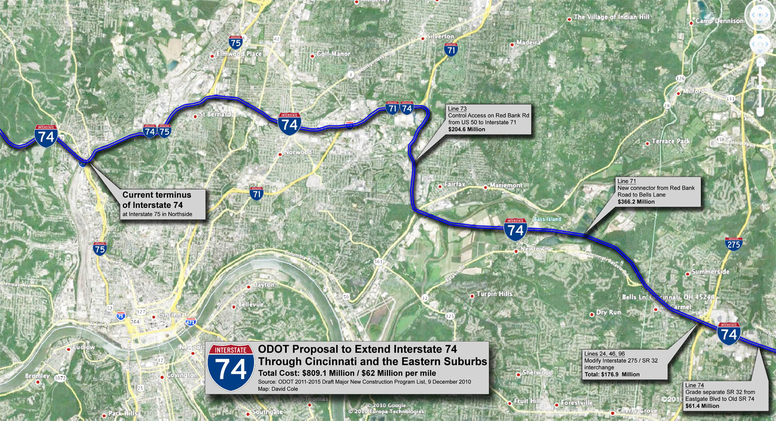
The Ohio Department of Transportation (ODOT) published its 2011-2015 Major New Construction Program List on December 9. The list included six funding allocations totaling more than $809 million of expressway work that will set the stage for the long-envisioned extension of I-74 through Cincinnati.
The money is being allocated through the veil of the controversial Eastern Corridor Project. $115 million has been budgeted for reconstruction of the US 32 – I-275 cloverleaf, grade separation of US 32 near this interchange, and modifications to Red Bank Road that anticipate its reconstruction as a fully grade separated expressway. Another $13.8 million has also been budgeted for the long-planned $366 million US 32 bypass and Little Miami River bridge between Red Bank Road and Interstate 275.
This partial funding of all segments of the Eastern Corridor Project on ODOT’s current Program List illustrates that the project is still very much on the table, and that ODOT will likely turn its full attention and funding toward the project after the reconstruction and widening of Interstate 75 is completed later this decade.
I-74 Extension Details
Many have suspected the use of the Eastern Corridor Project was being used as a veil for an interstate project, but until now there has been no financial backing to these claims. The extension of I-74, through Hamilton County, would be realized by upgrading US 32 between I-71 and I-275, and by upgrading other stretches of local expressways to interstate status and giving them the I-74 name. Once the extension is complete, I-74 would run from its current terminus at I-75 in Cincinnati to existing sections of I-74 in North Carolina.
In such a scenario, three miles of I-75 between Northside and Bond Hill would be co-signed as I-74, the entirety of the Norwood Lateral would become I-74, and I-71 between the Lateral and Red Bank Road would be co-signed as I-74. From that point, the planned “Eastern Corridor” US 32 bypass, which is being built to interstate highway design standards, can with the stroke of a pen become I-74.
Critical pieces of such a cross-county plan will soon commence construction as part of the I-75 Millcreek Expressway project. This year, the Millcreek Expressway project will fund $9 million in modifications to the I-74 Colerain Avenue interchange near Mt. Airy Forest. The nearby I-74/75 interchange in Northside, the present site of I-74’s terminus, is scheduled to be completely reconstructed in 2013. The I-75/Norwood Lateral interchange is scheduled to be rebuilt between 2016 and 2018.
Beneficiaries of an I-74 Extension
US 32 between I-275 and eastern Ohio, completed in the late 1990’s, was built to near-interstate specifications in anticipation of its future designation as I-74. In the fifteen years since its completion, it has attracted almost zero development along its more than 200-mile path. It is unlikely that replacement of its at-grade intersections with diamond interchanges will encourage increased private investment.
In the Cincinnati area, the most obvious beneficiaries of the Eastern Corridor plan, aside from those construction companies who would actually build it, are those who control tracts of land in Clermont County, who no doubt wish to develop large-scale sprawl along US 32 outside the I-275 loop. Such a roadway would only marginally improve the area’s access to downtown Cincinnati, and therefore strengthen the position of Kenwood, Blue Ash, and other suburban areas that compete with it for jobs and commerce.
The possible designation of the Norwood Lateral as an interstate would make its reconstruction a priority, and reconfiguration of its ramps could make possible the redevelopment of vacant land in Norwood and Bond Hill. Reconstruction of the I-71/Norwood Lateral interchange could accelerate the redevelopment of the Cincinnati Milacron site.
Potential Impacts
The US 32 bypass will negatively affect property values and the quality-of-life presently enjoyed by those who reside in the Newtown area. Additionally, the Sierra Club has campaigned against the highway’s Little Miami River bridge since the concept was introduced, arguing that its construction will negatively affect the river’s wildlife.
From the 1930’s on through the 1960’s, every mile of the 43,000-mile Interstate Highway System first appeared as a line on somebody’s map. In Cincinnati, remnants of abandoned subway right-of-way gradually became parts of what we know today as I-75, I-71, and the Norwood Lateral. The idea was to spread the population of Cincinnati into suburban areas. Another cross-town freeway in the form of I-74 will further depopulate the core of our region.
Our nation’s housing crisis and subsequent economic recession has led to an enormous increase in housing vacancy, abandonment, and foreclosures across the country. Hamilton County is no exception; the crisis has left many in the region homeless and has put a fiscal burden on local governments across the region, leaving them with the multifaceted challenges associated with widespread vacancy.
In many cases, property vacancy creates a domino effect that leads to further desertion and vacant properties within a neighborhood. This not only results in less tax revenue for cities; vacant property can also lead to increased rates of crimes such as drug dealing, prostitution, and arson. Because vacant property damages are so extensive, it is becoming more and more important for a metropolitan area to have a mechanism in place to transfer vacant property to owners who can/will pay taxes and redevelop the property.
A land bank is a tool that is growing in popularity, and on Tuesday morning local governmental and nonprofit leaders met to discuss how a Hamilton County land bank should be formed, funded and operated.
In April, Ohio Sub House Bill 313 was passed, enabling Ohio counties to create a Land Bank/County Land Reutilization Corporation (CLRC). The purpose of the CLRC is to facilitate the acquisition, reclamation, rehabilitation, and reutilization of vacant, abandoned, tax-foreclosed, and other real property. While there are still many steps that need to be taken before the CLRC is fully functional, county officials are hoping to have the land bank chartered by the end of the year.
Although no specific funding decisions were made at the meeting, there are multiple ways the CLRC can be supported fiscally. For example, the treasurer could recapture penalties and interest on delinquent taxes and assessments on behalf of the CLRC, the group could generate revenue from the resale of rehabbed property, and/or the CLRC could be authorized to issue bonds, accept gifts, and apply for grants. The recently announced NSP3 dollars can also be used to acquire homes for the CLRC.
Not only will the land bank help to address vacancy problems regionally, it will also give local CDCs and nonprofits a chance to obtain blighted property before private out-of-town investors. With a broad jurisdiction, the CLRC will be able to acquire both mortgage foreclosed and tax foreclosed properties. Moreover, the legislation allows land banks to waive delinquent taxes owed in order to clear the title on the property. This tax abatement component is crucial because often the taxes owed on abandoned property are more than the property’s actual market value.
At Tuesday’s meeting, there was a clear consensus that the land bank not just be a pilot program, but instead be a comprehensive and wide-ranging tool that helps to alleviate one of our region’s most pressing problems.
“The Board of County Commissioners want to ensure that the way this is set up is consistent with the community’s vision,” Assistant Hamilton County Administrator Jeffery Aluotto stated on Tuesday. “Land banking holds a great deal of promise as a means of addressing the increase in vacant housing stock we have seen since the recession, and the direct impacts that those vacancies have on the quality of life and economic vitality of our communities.”
The Eastern Corridor project, a multi-modal highway and commuter rail plan for eastern Hamilton County, is back in the news. Two weeks ago Cincinnati City Council voted against endorsing a TIGER II grant application seeking funds for the plan’s 17-mile commuter rail component.
The local media predictably turned this event into another city-county dispute, and insinuated that the TIGER II grant might alone fund construction of the entire Milford commuter rail line, which in 2003 was estimated to cost $420 million. There is no possibility of this happening, as Milford commuter rail would need to be awarded approximately two-thirds of the entire $600 million sum to be dispersed nationwide by the TIGER II program.
The media also ignored the Eastern Corridor plan’s central feature – four miles of the Milford commuter rail line is planned to be built parallel to a new $500 million U.S. 32 expressway between Red Bank Road and a point east of Newtown. The 1990’s cost estimate for Milford commuter rail included the savings associated with building a combined highway and rail project, including a new shared eight-lane bridge over the Little Miami River. The cost of building the commuter line first without provision for the future highway has not been studied.
The Oasis Line
Between downtown Cincinnati and the proposed eight-lane bridge over the Little Miami River, the Milford commuter rail is planned to operate on an eight-mile stretch of track paralleling the Ohio River known as the “Oasis Line.” In the late 1980’s the L&N Bridge (now the Purple People Bridge) was closed to freight rail traffic, and thus ended the operation of large trains along the Oasis Line. Since that time, traffic has been limited to a handful of freight cars per week, and the Cincinnati Dinner Train on weekends.
At first glance it would appear that implementation of commuter rail service on the Oasis Line should require nothing more than the purchase of commuter trains and the construction of a connection between the end of active tracks and the Riverfront Transit Center. Unfortunately, the poor condition of the existing track limits traffic to a maximum twelve miles per hour, meaning all eight miles between the Montgomery Inn Boathouse and Red Bank Road must be rebuilt. It is also probable that the Riverfront Transit Center connection must be built at least partially through Bicentennial Commons at Sawyer Point. All of this new track must be heavy freight railroad track, not the smaller and less expensive track used by light rail trains and modern streetcars.
Even after this needed investment in new track, grade crossings will remain at a half-dozen locations along Riverside Drive and in Columbia Tusculum, where perfunctory horn blasts will disturb those residing in new condos along Riverside Drive, longtime residents atop Mt. Adams and East Walnut Hills, and will surely be audible across the river in Bellevue and Dayton.
Poor Station Locations
Residents of Riverside Drive will be able to hear the Milford commuter rail trains, but most will not live within easy walking distance of the line’s stations. Of five stations proposed along the Oasis Line, only one, Delta Avenue in historic Columbia Tusculum, can be considered auspicious. By contrast, little existing ridership or future development exists around either the proposed Theodore Berry Park or the Cincinnati Waterworks (downhill from Torrence Parkway) stations. Ridership at the proposed Lunken Airport station will be minimal, and the Beechmont Avenue station will primarily serve as a bus transfer point.
On top of this minimal ridership, Riverside Drive is already served by Metro’s #28 bus. If Milford commuter rail is built, this bus will still have to operate due to the infrequent service and long distances between stations along the Oasis Line. It is also likely that Metro’s #28X, which serves Mariemont and Terrace Park en route to Milford, will have to continue operations as well.
An alternative proposal that called for streetcar or light rail service between downtown and Lunken Airport could eliminate the need for the #28 bus route, thus freeing up resources for bus service elsewhere. In this scenario significant savings would be achieved due to the considerably lower track costs for streetcars and light rail when compared to the freight railroad track currently proposed for the Milford commuter rail. Additionally, the vehicles are much quieter because they are electrically powered, labor costs are halved because they require just one driver, and more stops could be placed at much closer intervals.
High Operations Costs
No funding source has been identified to cover the outrageous annual operating costs for Milford commuter rail. In 2004 its annual operations were estimated to be $18.9 million — a sum similar to the estimated annual operating cost of the proposed 250-mile 3C Corridor passenger rail service between Cincinnati, Columbus, and Cleveland.
The cause of these exorbitant operating costs is an alarming combination of mediocre ridership and high labor costs. A 2002 report projected approximately 6,000 weekday trips (3,000 commuters) along the Oasis Line at full build-out. For comparison, this ridership figure is roughly equivalent to Metro’s most popular bus routes. At the same time, the FTA requires a crew of two onboard all diesel commuter trains that operate on freight tracks, even for the small Diesel Multiple Units (DMUs) planned for the Eastern Corridor, due to safety regulations.
By comparison, the Cincinnati Streetcar as presently planned will cost approximately $128 million to construct, require $3 million per year to operate, and will attract similar or higher daily ridership with 15 fewer route miles of track. Last month, city officials were notified that the Cincinnati Streetcar was awarded a $25 million Urban Circulator grant. If an identical amount were hypothetically awarded to the Eastern Corridor project through TIGER II, it would cover so little of the much more expensive Milford commuter rail that no construction would even be able to take place. Meanwhile, an additional $25 million put towards the Cincinnati Streetcar could extend the line into Avondale or Walnut Hills immediately. This means a potential grant for the Milford commuter rail might sit in the county treasury for a decade or more, or through tricky accounting be integrated into the Eastern Corridor project’s highway funding.
The Wasson Line
An alternative rail route to eastern Hamilton County involves use of the Wasson Line, which joins the Oasis Line near Red Bank Road but travels a very different path between that point and downtown Cincinnati. This route is eight miles – the exact same distance as the Oasis Line – but promises much higher ridership and much lower operational costs.
Since all freight operations ceased on the Wasson Line in 2009, electric light rail vehicles staffed by a single driver can be used at considerable cost savings over diesel commuter trains needed on the Oasis Line. Proposed station locations at Xavier University, Montgomery Road, Edwards Road, and Paxton Avenue each promise higher initial ridership — in 2002 the Wasson Line was estimated to attract 20,000 daily riders, or triple that of Milford commuter rail.
Also different from the Oasis Line, redevelopment potential exists around all of the stations locations along the Wasson Line, but especially the 25-acre parallelogram-shaped parcel recently assembled by Xavier University between its campus and Montgomery Road. The abandoned Wasson Road Railroad bisects this property and converges with the similarly abandoned CL&N railroad at the present edge of Xavier’s campus. The particular junction played a major role in the 2002 MetroMoves regional rail plan due to the convergence of several regional lines on their way into downtown along shared Gilbert Avenue tracks.
The Edward Road station is another location superior to anything on the Oasis Line. It is located within walking distance of Hyde Park Square and the majority of the neighborhood’s population. The station would be placed adjacent to, or across the street from, Rookwood Commons shopping center, and just a three-minute walk from the undeveloped Rookwood Exchange site north of Edmondson Road.
The Wasson Line has decisive cost-benefit advantages over the Oasis Line, but it obviously cannot function without a connection between Xavier University and downtown. After completion of the Cincinnati Streetcar, construction of a light rail connection between these points should be a top priority. This section alone promises the highest per-mile transit ridership in the metro area, and reaching Xavier University allows construction of three light rail branches, on existing railroad right-of-way, as funds permit.
Regional Priorities
It is unclear why construction of the Eastern Corridor project is any kind of priority. Much of the expense will be borne by Hamilton County, but with parts of the highway and rail line traveling over the undevelopable Little Miami River flood plain, the new expressway and perhaps even the rail line will act to encourage sprawl in Clermont County. Even the terminal station for the Milford commuter rail will not be in Milford’s town center, where it would be within walking distance of several hundred residents, but rather two miles away at Milford Parkway, home to Wal-Mart, Target, and chain sports bars.
Anti-rail forces are fond of saying that rail advocates will support anything that runs on rails. But advocates of better public transportation know that funds for rail projects are scarce and must be applied where the best cost-benefit exists. Moreover, the best transit mode must be chosen for each route. In the case of inner-city rail to Cincinnati’s eastern suburbs, diesel commuter rail along the Oasis Line is not the best solution, but rather, light rail service along the Wasson Line is.
")