Categories
Business Development News Politics Transportation

Is the Eastern Corridor Project a Trojan Horse for an Extension of I-74?

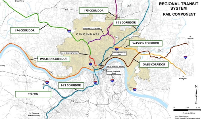
The Eastern Corridor Program has been part of Cincinnati’s political landscape since 1999. That year the Ohio, Kentucky, Indiana Regional Council of Governments (OKI) completed a Major Investment Study that envisioned construction of a new expressway between I-71 and I-275 and commuter rail service on existing freight railroad tracks as a multi-modal solution to limited east-west travel in eastern Hamilton County.

But are the incremental upgrades planned for Red Bank Road that appeared in the Ohio Department of Transportation’s (ODOT) December 21, 2013 Preferred Alternative Implementation Plan part of a long-term plan to extend Interstate 74 across Hamilton County and east to Portsmouth, OH?

A veteran of Cincinnati transportation planning thinks so. Speaking on terms of anonymity, a source claims that he was approached in the mid-1990s by Hamilton County officials and out-of-state toll road builders who sought to extend I-74 from its current terminus in Cincinnati at I-75 to SR 32 in Clermont County.

According to the individual, the Eastern Corridor Program charts a different route for I-74 across Hamilton County but it achieves a similar end. Specifically, it aims to open eastern Hamilton County and Clermont County to development in a way that interstate-quality upgrades to SR 32 east of I-275 could not alone achieve.

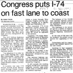
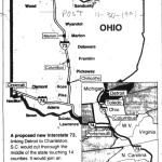
Extension of I-74 east to Portsmouth was widely discussed in the Cincinnati media in the early 1990s. On November 11, 1991, The Cincinnati Post reported that the newly passed Intermodal Surface Transportation Efficiency Act of 1991 named “an extended I-74 – and a new I-73 between Detroit and Charleston, SC, through Ohio – as one of 21 high-priority corridors”.

Planning for new sections of I-74 began in the early 1990s in North Carolina, and today 122 miles of I-74 are now open in that state.

While ODOT has never explicitly studied an I-74 extension, it did begin planning I-73 immediately after passage of the highway bill. This planning took place in an unorthodox manner when, in 1991, former Ohio Governor George Voinovich (R) directed the Ohio Turnpike Commission (OTC) – not ODOT – to study construction of a new interstate highway connecting Toledo, Columbus and Portsmouth.

An 80% toll hike in 1995 raised suspicions that construction of I-73 was imminent, however the OTC ended its planning 1997. This event appears to have coincided with West Virginia’s decision to slowly build its section of I-73/74 as a public/private partnership with various coal companies. With the end of I-73 planning also went any expectation that SR 32 might soon be upgraded to I-74 between Cincinnati and Portsmouth.

Since the conclusion of the Ohio Turnpike Commission’s study in 1997, ODOT has not explicitly planned for I-73 or the I-74 extension. However, many of its recent activities are consistent with the OTC’s plans in the 1990s.

On July 22, 2013 Governor John Kasich (R) announced that excess Ohio Turnpike toll revenue will fund construction of the $450 million Portsmouth Bypass, which was part of the Ohio Turnpike Commission’s 1990’s-era I-73 study, and is a critical link in the national I-73/I-74 plan. To be initially signed as SR 823, the Portsmouth Bypass will be a fully grade-separated and access-controlled highway – an interstate highway in everything but name.

No mention of I-73 or an I-74 extension appears on ODOT’s website; but an October 12, 2010 post on the National I-73/I-74 Association’s website named Steven Carter, Director of Scioto County (Portsmouth) Economic Development, as well as two officials from the Toledo area, as attendees at the association’s fall 2010 “Road Rally” in Washington, D.C.

Near Cincinnati, improvements to SR 32 are bringing the roadway closer to Interstate Highway design specifications. A new $32 million interchange is under construction at I-275, and the Clermont County Transportation Improvement District is studying full grade separation and controlled access from Batavia to the Brown County Line.

Within Hamilton County, ODOT divided a possible I-74 route into two separate projects: SR 32 Relocation and Red Bank Road upgrades. At an August 2011 public meeting, ODOT displayed drawings of Red Bank Road reconstructed as a fully grade separated and access controlled expressway. Those drawings do not currently appear on the project’s website.

New drawings shown at ODOT’s Oct 2, 2013 meeting and in its December 21, 2013 report are less ambitious but do not preclude a future full conversion of Red Bank Road into an interstate highway.

The project website states that the relocated SR 32 will “feel like a boulevard or parkway…it will not be a highway like I-71 or I-75”. However, no design feature presented to-date by ODOT prevents relocated SR 32 from being improved to full grade separation and limited access. In the meantime, planning and promotional activities for the future I-74 connecting the Midwest with the coastal Carolinas continue in earnest.

Editorial Note: In the coming weeks, we will publish two follow-up stories related to the Eastern Corridor Program. The first will take an in-depth look at the Portsmouth Bypass and West Virginia portion of the I-74 extension, and the second will provide an updated look at the program’s proposed Oasis Commuter Rail line.

Categories
Arts & Entertainment News Politics

URBANexchange to Highlight New Year

photo (6)

We’re back for the new year!  The first URBANexchange of the new year will be this Thursday at the Moerlein Lager House. This month’s event is dedicated to looking forward for 2014.

What are some of the things you’d like to see accomplished in Cincinnati during this new year? Drop by and lets talk about it over a drink!

As always, the event will be a casual setting where you can meet others interested in what is happening in the city. We will gather in the biergarten so that each person can choose how much or little they buy in terms of food or drink. Although we do encourage our attendees to generously support our kind hosts at the Moerlein Lager House.

Our team of researchers and writers will also occasionally dive further into the topics and publish the information and ideas on the website.

URBANexchange is free and open to the public. This month we are giving away two $25 gift cards from the Lager House as door prizes so be sure to drop your name into the raffle.

We will be situated in the northwest corner of the biergarten (near the Moer To Go window), but you can also ask the host where the UrbanCincy group is located and they will be happy to assist.

The Moerlein Lager House is located on Cincinnati’s central riverfront and is located just one block from a future streetcar stop. Free and ample bike parking is available near our location in the biergarten outside by the Schmidlapp Event Lawn.

Categories
Development News Transportation

Elm Street Cycle Track Would Provide Critical Link for Region’s Bike Infrastructure

The city will start construction on physically separated bike lanes along Central Parkway, from Downtown to Clifton, this coming spring. Following a community engagement process, a final design was selected in recent weeks, and the large addition to Cincinnati’s bike network is expected to make a significant impact.

Not only will it be one of the most impressive bike facilities installed in the region to-date, but it will also link neighborhoods together that have large percentages of bicyclists. Furthermore, it will link other bike facilities with one another, and come close to linking even more.

Some of the existing facilities include numerous bike lanes and the Mill Creek Greenway, but the Central Parkway bike lanes will come about 12 blocks shy of connecting with the Ohio River Trail, which then links to the Little Miami Scenic Trail.

A two-way cycle track should be built in order to connect the new Central Parkway bike lanes with the Ohio River Trail and beyond.

Elm Street Cycle Track

There are two streets that connect from Central Parkway to the Ohio River Trail along Mehring Way without interruption: Main Street and Elm Street. Both of the streets have one-way traffic heading northbound, but Main Street is considerably more congested with cars and buses heading to Government Square.

Elm Street, however, has some of the least congestion of any north/south street in the Central Business District and could easily connect the Central Parkway cycle track with the Ohio River Trail. A reorganization of the street would need to occur however.

Presently Elm Street, from Central Parkway to Mehring Way, lacks consistency in its design with on-street parking located haphazardly along both sides of the street. A reconfiguration of the street could consolidate all on-street parking to the east side of the street, thus eliminating only a nominal number of on-street parking spaces, and maintain 2 to 3 moving traffic lanes (the parking lane could be restricted during rush hours to allow for a third travel lane).

The Elm Street cycle track, meanwhile, would be located along the west side of the street and be buffered from moving traffic by a row of bollards. Such a redesign of Elm Street would be a bit of a road diet, but one that seems reasonable for this stretch of overbuilt roadway.

Planners with the City’s Department of Transportation & Engineering (DOTE) said that the idea of an Elm Street cycle track had not come up before, and has not been presented to any formal committees or community councils to-date. Such coordination, they say, would need to take place prior to the idea moving forward.

With future phases of The Banks and the yet-to-be-named residential tower on Fourth Street set to begin construction soon, there seems to be an opportunity to rebuild this roadway along with those projects. This would help offset some of the costs and make for a more seamless transition.

Projects like this are low-hanging fruit for the new mayor and council, should they wish to pursue investments that improve the city’s bike infrastructure. They should work with the bike community and come up with a strategy that provides a clear path forward to make this happen.

An Elm Street cycle track like this would provide a critical link in the region’s bike network, make the street safer, more accommodating to more users and more attractive to those who currently find themselves along the now bleak and desolate stretch of roadway. Let’s get to work.

Categories
Business Development News Politics Transportation

Cincinnati’s Streetcar Victory a Decade in the Making

The final, final, final vote for the first phase of the Cincinnati Streetcar took place today. Perhaps by now you all know the outcome. A six-person veto-proof super-majority voted to continue construction. Cincinnati, as Mayor John Cranley (D) said today, will have a streetcar.

What is important in this moment is to realize that everyone involved lived up to their campaign promises. Wendell Young (D), Chris Seelbach (D) and Yvette Simpson (D) stood strong in their support of the project – even in the face of uncertain outcomes.

At the same time, Christopher Smitherman (I), Amy Murray (R) and Charlie Winburn (R) held true to their promises to oppose the streetcar no matter what. They were the three lone votes against restarting construction.

Construction work will soon resume on Cincinnati’s $133M streetcar project. Photographs by Travis Estell for UrbanCincy.

Then there are the three council members who campaigned on taking a serious look at the numbers and making a prompt decision about whether to cancel the project or proceed. P.G. Sittenfeld (D), David Mann (D) and Kevin Flynn (C) all did that once they saw the numbers in detail. Cancelling a project this far along would have been fiscally irresponsible, and they voted true to their campaign promises to be good stewards of the taxpayer’s dollars.

UrbanCincy has been covering this project since we started the website back in 2007. Our original coverage focused on redevelopment efforts in Downtown and then Over-the-Rhine, but the streetcar quickly became a big part of that redevelopment narrative. It is no secret that we are strong supporters of the project and believe it will improve mobility in the center city and set the city on a path toward building the regional rail system everyone seems to now desire.

There are many people responsible for getting Cincinnati to this stage, but the biggest credit must absolutely be given to John Schneider. If it were not for his unrelenting leadership on this issue over the past decade, we would not be anywhere close to where we are now.

The emergence of Mayor Mark Mallory (D) then gave the city a prominent leader to push the project forward, and Mallory leaned on the expertise and leadership of former City Manager Milton Dohoney and Vice Mayor Roxanne Qualls (D) to get it all done.

It is important to keep in mind that the person who first pushed for the Uptown extension to be included in phase one was in fact Roxanne Qualls. The Uptown Connector was never part of the original phase one plan, but was added in later as “Phase 1b” at the urging of Qualls, who then worked with Mallory and then Governor Ted Strickland (D) to secure state funding to make that happen.

Hard fought victories in 2009 and 2011 helped keep the project alive, but also delayed it and ran up the project’s costs. Those delays also allowed enough time for Governor John Kasich (R) to assume office and pull the $52 million in state funding Ohio had originally pledged.

So while Qualls’ leadership and vision to have the first phase include the Uptown Connector is not being realized at this exact moment, our attention must now turn to extending the streetcar line to neighborhoods in Uptown as quickly as possible.

Cincinnati Regional Rail Plan
The first phase of the Cincinnati Streetcar system is a small part of a much larger regional rail plan envisioned by leaders. Map provided by OKI Regional Council of Governments.

A new wave of leaders and organizers has emerged in Cincinnati as a result of this most recent battle over the streetcar project. This includes the heroic efforts of Eric Avner and the Haile/U.S. Bank Foundation for drumming up private support to contribute $9 million toward the project’s ongoing operations.

Their hard work and courage should certainly be commended, but let’s also not forget the people who have been pounding the pavement on behalf of the streetcar since the beginning. Most Cincinnatians in 2007 did not know what a streetcar was, much less a modern one and the benefits it would bring. The hard work put in by those people early on was necessary.

This movement was not built overnight and these supporters are not fair-weather fans of the city. The movement has grown in size and grown more sophisticated over the past decade and is now stronger than ever.

You too can join this urbanist movement in Cincinnati.

We gather at the Moerlein Lager House around the first Thursday of every month to host URBANexchange – an urbanist networking and social event. We also partner with the Niehoff Urban Studio at the University of Cincinnati to study complex issues facing our city and engage the public in that dialog. Please join us at our next URBANexchange and pay us a visit in Corryville for our next event with the Niehoff Urban Studio.

Now is a time to celebrate and reflect. But it is not the time to get complacent. There are more issues to address and this energy that saved the streetcar needs to be redirected there. Congratulations, Cincinnati! Let’s get to work.

Categories
Up To Speed

America’s infrastructure is spread far and wide, without enough people to pay for it

We Only Notice When the Pipes Burst – Next City.

As readers of UrbanCincy know, America has put off paying its infrastructure bills for some time and now has an increasingly terrible standard of roads, bridges, sewers, pipes, transit and energy. But what can or should communities throughout America do? They have infrastructure spread far and wide to support far-flung suburbs that defined The American Dream through much of the 20th century. While those early generations were able to sit back and enjoy the new suburbs, the bills of replacing this infrastructure are now coming due…and the communities are not densely populated enough to be able to properly fund the maintenance. More from NextCity:

Earlier this year, when the American Society of Civil Engineers released its quadrennial report card on the nation’s infrastructure, it gave a D to drinking water. The report estimated that there are 1 million miles of water mains in the country, some dating back to the mid-19th century and many in dire shape…Unlike bridges, roads or many other types of infrastructure, the pipes that carry our water are underground and out of sight. It’s only when they break — which, according to the ASCE, happens about 240,000 times each year — that people become aware of the problem.

“The top concern is our aging infrastructure and how we’re going to go about ensuring it’ll be around for future generations,” Kail said. “Over the next 25 years, it will cost U.S. communities more than a trillion dollars to repair water infrastructure. And by that I mean pipes in the ground. That’s a challenge for a lot of communities, especially small ones. Rural communities have many miles of pipes and not many people to spread the cost.”