Categories
Business Development News

Are Regional Population Trends in Cincinnati and Dayton Entangled?

Anyone in this region knows that Cincinnati and Dayton are closely influenced by one another. Perhaps you could say that Cincinnati, being significantly larger, influences Dayton more than Dayton influences Cincinnati, but you might not want to say that to anyone in charge at the Cincinnati-Northern Kentucky International Airport.

A new study conducted by Alberto Hernando de Castro for the École Polytechnique Fédérale de Lausanne in Paris found two trends in the population growth and decline of Spanish cities. His team was able to determine these trends by developing a model based on population data collection from 8,100 Spanish municipalities between 1900 and 2011.

One of the trends Hernando’s team noted in the study was that a city’s growth rate depends on the growth rates of neighboring cities. And it was specifically noted that cities within 50 miles of one another become “entangled” in a way that if one grows, the other grows as well. It is this trend that is perhaps most interesting for the Cincinnati-Dayton metroplex, where the two core cities are less than 50 miles apart.

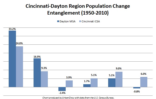
Cincinnati-Dayton Region Population Change Entanglement

The primary cities of both regions peaked in terms of their population in the middle of the 20th century, but metropolitan area population growth has more or less continued for both up through the 2010 Census.

The Dayton metropolitan statistical area (MSA), with 841,502 people, has suffered two decades of population decline – the first from 1970 to 1980 and the second from 2000 to 2010. The Cincinnati combined statistical area (CSA), meanwhile with 2,172,191 people, has never recorded a decade of population loss.

With that said, the population growth trends for the two cities do tend to mirror one another. From 1950 to 1980 both regions saw their population growth slow significantly, with Dayton leading the way. The two areas then saw an uptick from 1980 to 2000, with Cincinnati leading the way.

If the Cincinnati-Dayton metroplex is in fact following this trend noted by Hernando and is researchers, then it would appear that Dayton’s slowing growth in the middle part of the 20th century brought Cincinnati’s down with it, or whatever factor led to this change in Dayton had similar effects on the nearby Cincinnati market.

The same would be true, but in opposite fashion, for the latter part of the century when Cincinnati’s rebounding population growth seemed to pull Dayton along with it – even reversing the slight population decline the Dayton MSA experienced in the 1970s.

The other trend noticed by the researchers was that cities seem to grow based on a 15-year memory – meaning what happened within the past 10 to 15 years serves as a reasonable indicator for what will happen in the next few years. This analysis, of course, is more accurate the closer the years are to the base year, and less accurate the closer the data is to the 15-year extreme.

If this trend is also true, might it mean that the Dayton MSA will post a population gain between 2010 and 2020, as a result of Cincinnati’s population gains lifting up Dayton’s population decline as it did in the 1980s? Or will it mean that the population gain for the Cincinnati CSA will be even less than the 6% gain posted last decade, as a result of whatever is dragging down population gains in Dayton?

Time will tell, but so far the two noted trends seem to apply to the Cincinnati-Dayton metroplex. In what way, exactly? Good question.

Categories
Up To Speed

Where is the consistency and simplicity in design of pedestrian infrastructure?

Where is the consistency and simplicity in design of pedestrian infrastructure?.

Our friends and fellow Streetsblog Network compatriots at Streets MN have knocked it out of the park with their recently analysis and critique of pedestrian crossing design. Why do pedestrians need to press a button to activate a cross walk signal? Automobile drivers need not do the same. And why isn’t the design of our intersections simple enough so that pedestrians can easily and safely cross a street without needing 11 lines of instructions complete with images? More from Streets MN:

Traffic signals on streets with sidewalks (which implies pedestrian traffic either exists or is desired) should ALWAYS have an automatic walk phase, just as every cycle gives green time to cars from every approach. Actuators are fine if they make the walk signal come sooner, but being unpushed should not be used as an excuse not to have a walk phase at all. Car drivers don’t have to go out of their way to press actuators, why should pedestrians?

If traffic is so low you are concerned the time devoted to a pedestrian phase (~12 seconds – 36 ft at 3 fps) is too long (will cause too much vehicle delay) for this two lane roadway, maybe it shouldn’t be a signal but instead a stop sign (which requires no pedestrian signal) or a yield sign. This can be implemented with flashing red lights if you must you electrical gear.

Categories
Development News Transportation

UC Planning, Engineering Students Propose Hamilton Avenue BRT Corridor

Hamilton Avenue BRT CorridorLast fall UrbanCincy partnered with the Niehoff Urban Studio on an event that highlighted the work of an interdisciplinary group of students. That semester engineering and planning students focused on urban mobility and looked at bikeways and bus rapid transit ideas within the city.

Each of the student groups presented their final research and findings to fellow academics and industry experts from around the region. We then gathered a group of transit and bike experts to engage in a panel discussion about the student’s proposals and about transportation in the region in general.

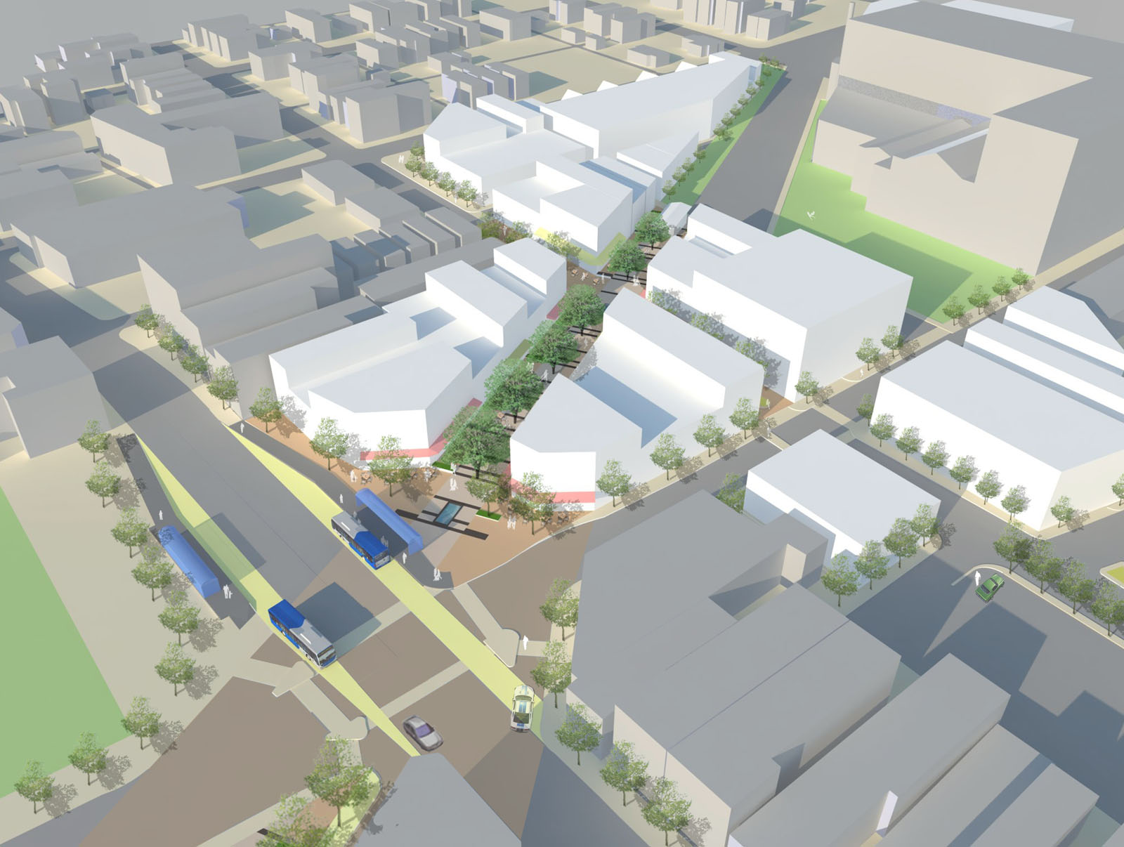
Throughout the course of the day, we asked members of the public who attended to vote on their favorite proposal. The winner was a bus rapid transit corridor along Hamilton Avenue that focused heavily on a transit-oriented development (TOD) in Northside where The Gantry is now being built.

The six-person team consisted of Tyler Kiefer, Benjamin Lafferty, Christopher Murphy, Michael Orth and Michael Walsh from the College of Engineering & Applied Science and Alexander Cassini from the College of Design, Architecture, Art & Planning.

First and foremost, the group said that their Hamilton BRT Line would most closely resemble Cleveland’s highly publicized HealthLine, which is the highest-rated BRT line, by far, in North America. The group also examined lines in Pittsburgh and Kansas City.

One of the main reasons for the comparisons to Cleveland is the similarities between the corridors. In both Cincinnati and Cleveland, the corridors connect neighborhoods under-served by transit to institutional services, while also providing greater mobility.

“The 2010 U.S. Census has shown how the population along Hamilton Avenue has less access to quick and reliable means of transportation when compared to the stats of Cincinnati and Ohio as a whole,” explained Masters of Community Planning student Alexander Cassini. “This lack of mobility directly affects citizens’ access to essential services and employment opportunities.”

Their research found that Metro’s #17 bus route, which most closely aligns with their proposed BRT corridor, currently averages weekday ridership of about 4,500 people. Furthermore, they found that approximately 17% of the households along the corridor have no car, 10% of the commuters identify as bus riders and there are 6,387 people living per square mile.

The proposed BRT corridor runs from Downtown to North College Hill, and the engineering and planning students saw this particular corridor as a major opportunity to spread investment and attention from the center city to additional neighborhoods that would take advantage of the BRT route’s 12 stations spaced out between one-half mile to three-fourths of a mile apart that would ensure faster and more efficient service. Each of the 12 station locations, Cassini notes, was selected due to its significant population and employment nearby.

“Northside and North College Hill are historic places in the city and present a great opportunity for Cincinnati to keep growing as a city,” noted civil engineering student Michael Orth.

Orth went on to say that while one of the positives of this corridor was the amount of people and businesses it could positively impact, the area’s congestion was also one of the team’s greatest challenges, stating, “There is very little room to implement a bus only lane throughout the corridor, which would be ideal for a BRT line.”

To help address this situation the group said that they envision a bus only lane, or a hybrid lane for buses and cars depending on the hour, through the congested portions of the route. Although not recommended, if a hybrid lane was determined to not be satisfactory Orth said that further study could be done to examine whether there would be enough benefit to remove on-street parking in order to provide for a consistent, dedicated bus only lane.

Other technology to help facilitate the quick movement of buses along the corridor would include arrival detection at traffic signals so that the lights can change in order to accommodate an approaching bus.

Existing Metro bus service, they said, would largely be redeployed to avoid redundancy, but some would remain since local buses stop more frequently – potentially creating a corridor of localized bus and express BRT service.

Hamilton Avenue BRT in Metro*Plus Context
One area where the Southwest Ohio Regional Transit Authority (SORTA) has already begun enhancing bus service is along Montgomery Road, which connects Downtown with the Kenwood area. That new Metro*Plus service, while not full BRT, is a step in the right direction according to the University of Cincinnati students, and has already seen ridership triple since its upgrade.

“Metro*Plus service is good but it is only the first step towards a true BRT system for the Cincinnati metropolitan area,” Cassini cautioned. “Metro*Plus service can be even more efficient, and effective if totally dedicated lanes and other additional features are added.”

Reading Road, where Metro began operating articulated buses in 2010, is actually the region’s most heavily utilized bus corridor with Hamilton Avenue coming in second and Montgomery Road third. If Metro is to continue to build out its enhanced bus service, or full-on BRT operations, then Hamilton Avenue may very well be the next logical choice.

What helped the group’s proposal stand out from other presentations was its focus on the TOD in Northside. With a $13 million mixed-use project coming out of the ground on that site now, the group reflected on their own proposal.

While the team had collectively noted the large, clean open space as being one of the huge benefits of the site, it also made it particularly valuable in their opinion. As a result, several of the group members, while encouraged about the private investment, were also a bit underwhelmed by the Indianapolis-based Milhaus Developers’ architectural design.

Both Cassini and Orth mentioned that they would be interested in working full-time in the transportation industry someday, but for different reasons. When asked to briefly compare the wide variety of transportation projects current in the planning or development stages around the region, there was a uniform response that their excitement is for the Cincinnati Streetcar.

“Although the planned streetcar line does not expand sufficiently in our eyes, we believe it would be an incredible economic development booster for Cincinnati’s downtown and overall urban core,” Cassini explained. “The overall transportation efforts around Cincinnati will eventually pay off to form a comprehensive and more easily navigable system than today.”

The Niehoff Urban Studio is currently working with a new set of students on designs for the Wasson Corridor, which runs through several of Cincinnati’s eastern neighborhoods. This is another topic that was examined by one of the interdisciplinary groups of planners and engineers last year. UrbanCincy is once again partnering with the Niehoff Urban Studio and will be organizing a similar showcase and panel discussion in 2014.
Categories
Up To Speed

New app allows users to tell their Congressional reps about inadequate transport

New app allows users to tell their Congressional reps about inadeqate transport.

Do you find yourself frustrated by traffic congestion, lack of bike lanes or sidewalks, inability to take a bus or train to your destination? Well, Building America’s Future has released an updated version of their ‘I’m Stuck!’ app that allows people to directly send messages to their Congressional representatives – urging them to start funding the necessary improvements to make our communities mobile and safe. More from Streetsblog Capitol Hill:

Among the new features of their app redesign, BAF has added a way to tell Congress you need better bicycle infrastructure… According to BAF, the app has been downloaded 11,000 times and 3,500 messages have been sent to Congress. The old version didn’t let them track how many were complaining about sitting in traffic versus how many were complaining about inferior transit. And as we mentioned last time, you’ll have to customize your message if you want to make sure Congress knows that you’re not asking for more car lanes but rather a transit line that would get you off the road altogether. And remember, distracted driving rules apply.

Categories
News Transportation

Streetcar Spurs Unsubsidized Growth in Portland

Portland is often cited as the “go to” city for rail transit and good planning initiatives. As someone who had ridden a fair share of streetcar, light rail and subway systems, I traveled to Portland with a dose of skepticism. TV shows like “Portlandia” showcase the quirky and often times absurd hipster culture that has blossomed in the city despite chronic problems with homelessness.

For a Cincinnatian, downtown Portland is a showcase of what could have been for downtown Cincinnati. A brief detour into Pioneer Place mall shows the potential of the failed Tower Place mall in downtown Cincinnati. A block away there is a downtown Nordstroms, something downtown Cincinnati failed to land in the 1990’s. A few blocks away, there is a downtown Target and TJ Maxx. The city’s retail scene is vibrant and its eclectic arrangement of food trucks and bicycle infrastructure add to that vibrancy.

It seems strange that these similarly sized metropolitan regions have realized two very different fortunes. One is of success through investing in transit infrastructure, the other struggling to make gains so far without it. This is why the construction and success of the Cincinnati Streetcar project is so vital.

Twenty-five guests of the Alliance for Regional Transit, spearheaded by John Schneider, toured Portland last month to ride the various modes of transit in the city and tour the different areas along the city’s expanding streetcar system. This is the 30th group Schneider has led out to Portland and also the largest.

Schneider has not always been a fan of rail transit. Citing the availability of bus transit, he was often critical of the need for rail in cities like Cincinnati. After the formation of Downtown Cincinnati Inc. (DCI), however, a survey was conducted where rail transit was found to be the top priority for downtown residents and visitors. He was assigned as the head of the Transportation Committee and tasked with bringing rail to the region, something he scoffed at at the time.

When recounting this story, he told the group in Portland that he had ridden several systems until one day he was riding a train in St. Louis and it finally clicked. The self-identified Republican has been a supporter ever since.

The tour began at the South Waterfront district, located at the southern end of the North-South (NS) Streetcar line. It is a new neighborhood that serves as the residential and office extension off the Oregon Health Sciences University Hospital, which is landlocked at the top of the adjacent hill.

The $1.6 billion development started in 2004 and is home to thousands of residents. An aerial tram serves as a direct connection between the South Waterfront and the hospital. The tram also offers dramatic views of the city and the surrounding Cascades mountain range.

The east side of Portland, opposite the Willamette River, is primarily dominated by auto-oriented developments, however there is evidence that the recently opened Central Loop (CL) Streetcar line is having a positive impact on development in the area. A $250 million upscale apartment development has already begun construction at the junction between the streetcar and light rail lines at NE 7th Avenue and NE Holladay Street in the sleepy Lloyd District.

The next phase of the Portland’s streetcar system will connect the end of the CL Line in the east end to the end of the NS Line near the South Waterfront. To accomplish this the city is building a $134.6 million cable-stayed rail, bike and pedestrian only transit bridge that will open in 2015.

The tour also took the group through the Pearl District, which is the oft-touted renovated warehouse distinct in Portland.

While there are many comparisons to Cincinnati’s Over-the-Rhine neighborhood, it would be an unjust assumption because Over-the-Rhine features a greater amount of remaining abandoned and underutilized mixed-use multi-family buildings than the Pearl District. The Pearl District has seen over $2 billion in development, but it has largely been new construction built on sites that once were once occupied by rail yards and warehouses.

During the tour the group was introduced to different leaders who shared their perspective of Portland’s progress on its streetcar system.  People like Paddy Tillett, Principle at ZGF Architects, who is with the firm that helped spearhead the effort to establish the transit mall in downtown Portland.

“People were calling it a toy train and saying that we already had light rail,” Tillett told the group. “Even TriMet didn’t want to operate it.”

However Portlanders soon came to embrace their streetcar system, which is now in its fifth phase of construction. Tillett continued, “The streetcar helps extend peoples walking distance, it is not supposed to serve as point-to-point transit. Today it has a dedicated ridership and is helping demonstrate how streetcars can play an important role in public transit around the country.”

The tour was capped off with a meeting with Portland Mayor Charlie Hales (D). Hales told the group, “We no longer have to provide subsidies for downtown development.”

Mayor Hales also stated that it took fifteen years for developers to begin  reducing the size need of parking structures for development.

Portland is a beautiful city with vibrancy and life. However, this vibrancy was hard fought over the last three decades. The construction of the transit mall, TriMet light rail and the streetcar were huge gambles that ultimately paid off, and took Portland from a sleepy waterfront lumber town to a place where people move to even if they don’t have jobs lined up. Portland’s problems are ones born from success, not failure and even those problems are good to have.

At today’s council meeting, Cincinnati’s new political leadership will be making decisions regarding the continuation of construction of the Cincinnati’s streetcar system. The new mayor and city council will have to decide whether to continue the same hit or miss approach to development in the urban core, or decide to embrace a system that has a proven track record of success in many cities throughout the country and the world.

Cities like Portland are where the future is headed, Cincinnati’s new leaders should take heed.