Categories
News Transportation

Cincinnati Seeking Feedback on Two Bike Infrastructure Projects

The City of Cincinnati is studying two new streets for potential bicycle enhancements, and officials with the Department of Transportation & Engineering (DOTE) are looking for the public’s feedback.

The first project is on Delta Avenue where they are considering adding a five-foot bike lane on both sides of the street, and the second is a larger project along Central Parkway that is considering adding either striped bike lanes or physically separated cycle tracks along a 2.2-mile stretch of the roadway.

Delta Avenue Bike Lanes
The Delta Avenue project will take place between Columbia Parkway and Erie Avenue, but will not impact Mt. Lookout Square. DOTE officials say that the schedule calls for repaving to begin in early 2014.

Right now planners and engineers are looking at two options for Delta Avenue. One option would maintain the existing roadway conditions that include two 10-foot travel lanes and two 18-foot travel/parking lanes.

Delta Avenue Proposed Section

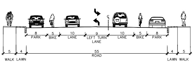
The second option would modify this layout to include two 5-foot bike lanes, two 10-foot travel lanes, one 9-foot left turn lane, and two 8-foot parking lanes.

The proposed reconfiguration, DOTE officials say, would provide safety benefits for bicyclists, pedestrians and automobile drivers, and is similar to what was recently installed on Madison Road between Woodburn Avenue and O’Bryonville.

In addition to improving bicycle accessibility along Delta Avenue, the new bike lanes would connect into the recently installed bike lanes on Riverside Drive, which will be extended into the downtown area later this year.

“Delta Avenue is a primary cycling route from Riverside and downtown to the city’s eastern neighborhoods, and these plans will help to calm traffic and make the street safer for cyclists, pedestrians and motorists,” Queen City Bike president Frank Henson stated.

Those interested in sharing their feedback regarding the Delta Avenue project can do so by visiting the City of Cincinnati’s webpage for the project and answering a few brief questions.

Central Parkway Cycle Tracks
The larger Central Parkway project is planned to be built in two phases, with the first phase of work stretching from Elm Street in Over-the-Rhine to Marshall Avenue in Fairview.

Neighborhoods along the first phase of the project have already been approached about the project, and the City of Cincinnati received a $480,000 Transportation Alternative grant from the federal government, administered through the OKI Regional Council of Governments, in June 2013.

This portion of the work is being studied in three separate segments due to existing roadway configuration.

Dearborn Street Two-Way Cycle Track
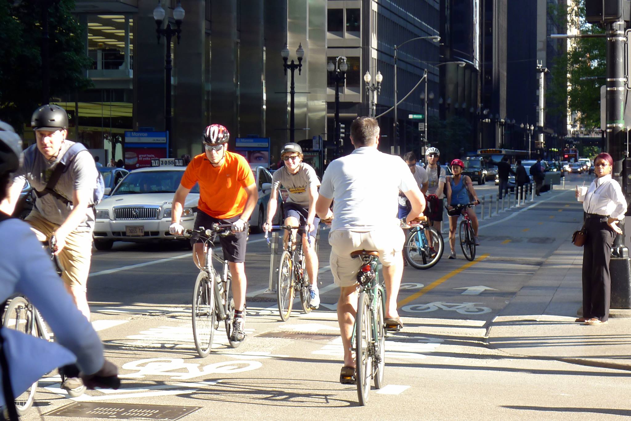
City officials are looking into the possibility of installing a two-way cycle track along Central Parkway – similar to Chicago’s two-way cycle track on Dearborn Street. Image provided by Active Transportation Alliance.

The first segment is from Elm Street to Liberty Street, and due to the median that divides Central Parkway there, it is considered unfeasible to have a two-way cycle track. As a result, the DOTE is considering only two options – the existing road with no enhancements or one-way cycle tracks on both sides of the street.

The second segment being studied in phase one is from Liberty Street to Brighton Avenue, and is studying three options in addition to the existing conditions. The first would be a 14-foot, two-way cycle track on the west side of the street, the second would be 7-foot-wide one-way cycle tracks on both sides of the street, and the third would be 5-foot bike lanes on both side of the street.

The final segment within the first phase of the Central Parkway project is from Brighton Avenue to Marshall Avenue. Here, the same three options are being considered as for the second segment. The only difference being the two-way cycle track on the west side of the street would be 12 feet wide instead of 14 feet.

“Adding a cycle track to Central Parkway will create a safer, family-friendly space for people on bicycles and will exponentially increase the number of people using bicycles in this corridor,” explained Mel McVay, senior city planner with Cincinnati DOTE. “This project is a game changer for Cincinnati – it has the ability to completely change the way people feel about riding bicycles in our city.”

Those looking to share their thoughts on which design option would be best can do so by completing a very short survey on the Central Parkway project’s webpage.

The second phase of work along Central Parkway would then progress northward from Marshall Avenue to Ludlow Avenue, where the city’s first green bike lanes were installed in November 2012. The details have not yet been worked out for this phase of work, but will progress as soon as funds become available.

“Both of these projects would be extremely beneficial if completed,” noted Queen City Bike executive director Nern Ostendorf. “What bike lanes and especially cycle tracks do is they expand the accessibility of biking on city streets to more users who consider biking on roads without special bike facilities too dangerous, or at least too stressful.”

This story was originally published in the July 19, 2013 print edition of the Cincinnati Business Courier. UrbanCincy readers are able to take advantage of an exclusive digital membership and access all of the Business Courier‘s premium content by subscribing through UrbanCincy‘s discounted rate.

Categories
Arts & Entertainment Business News

PHOTOS: Mayor Mallory Energizes Supporters at Streetcar Social

Hosting their monthly Streetcar Social, Cincinnatians for Progress braved the summer heat wave at Rhinegeist Brewery as crowds gathered to listen to the featured speaker of July.

Cincinnati Mayor Mark Mallory (D) took to the stage, presenting an update on phase one of the Cincinnati Streetcar project, to a room filled with approximately 200 supporters. Several City Council members were also present, including Wendell Young (D), Laure Quinlivan (D), Chris Seelbach (D), and representatives for Vice Mayor Roxanne Qualls (C) and City Council Candidate Mike Moroski (I).

The Mayor spent the beginning of the event mingling with the crowd, followed by delivering a 20-minute presentation that recapped the official signing of the streetcar construction contract with Messer, and the continued progress with utility relocation along the phase one route.

An updated CAF streetcar model was shown with interior finishes, and Mayor Mallory explained that Cincinnati’s five streetcars will have cutting-edge technology that will be the first of their kind to operate in North America.

Mayor Mallory also showed a rendering of the streetcar maintenance facility, which will be erected in the lot adjacent to Rhinegeist, and explained that the current cinder-block structure will be demolished so that the new facility can be built along Henry Street.

“We’ve decided to name the maintenance facility the Center of Advanced Streetcar Technology, or COAST for short,” Mallory quipped to a boisterous audience, as he commented about the anti-streetcar group with the same acronym.

The mayor continuously expressed his gratitude for supporters, both new and those who have been on for the long haul.

“Investing in the Cincinnati Streetcar will help stabilize the city’s tax base and repopulate the Queen City; the greatest challenge facing us today.”

All photographs were taken by Paige Malott and Travis Estell for UrbanCincy.

Categories
Up To Speed

Setting the Score Card for Transit Oriented Developments

Setting the Score Card for Transit Oriented Developments

With the City of Cincinnati signing the streetcar construction contract yesterday, discussion can now move on to the type of transportation oriented projects that can be constructed along the streetcar route and its eventual extensions. The measure the impact of projects located near rail transit stops the Institute for Transportation and Development Policy (ITDP) has created a metric for rating projects developed near transit stations to determine if they are truly transit-oriented or merely transit adjacent. Read more at the Transport Politic:

The tool was simple to use and its results make sense intuitively: Whereas the MetroWest project is poor urban design from the perspective of encouraging transit use, the other two are far more oriented toward the nearby rail stations. Hypothetically, if the projects were all proposed for the same site, the tool would allow decision makers to make a quick quantitative comparison between the designs and identify the best project for public transportation riders. This could offer a clear benefit in terms of, for example, choosing a winning team for the contract to develop a publicly owned site. Rather than rely on “subjective” comparisons of the aesthetics of site designs (a comparison that too often devolves into a question of individual architectural taste), the tool quantifies the physical.

Categories
Business News Transportation

Industry Experts Believe a ‘Parking Revolution’ is Sweeping America

In April of this year, members of the International Parking Institute, the world’s largest association representing the parking industry, surveyed parking professionals to determine trends and gain input on parking and related topics.

The survey results found that a “parking revolution” is taking place in the United States, and that the industry is beginning to embrace a variety of new parking solutions.

“The industry is embracing a variety of new technologies that make it easier for people to find and pay for parking, and for parking authorities to better manage it,” the report stated.

Cities identified as leaders in the movement included San Francisco, Portland, New York City, Seattle, Miami, Houston, Boston, Denver, Pittsburgh, Washington D.C., and Tampa.

Emerging Parking Trends

Cincinnati’s recently approved Parking Modernization & Lease Program appears to apply these top trends by moving toward technologies that improve access control, payment automation, and real-time communication of pricing and availability to user’s mobile devices.

These kinds of features are the new standard being implemented around the country, and are provided by Cincinnati’s lease agreement.

Parking professionals were also asked to identify the ten most progressive municipal parking programs in the United States, with San Francisco’s SFpark named most innovative.

“The SFpark pilot project provides real-time information on parking availability and cost; reduces double parking, circling, and congestion; and improves parking ease and convenience,” the report stated. “A high-caliber data management tool allows the San Francisco County Transportation Authority to make rate-change recommendations, supply real-time data, maintain optimum operational and contractual control, and rigorously evaluate the pilot’s various components.”

Respondents also said that SFpark was particularly bold in requiring city and government employees to pay for parking in order to bolster the program’s credibility before asking voters to consider sweeping changes in parking management.

Of particular interest is SFpark’s on-street rate adjustment policy.

Prior to the changes, rate adjustments were made during the budget-planning process. The goal with the pilot program is to take a demand-based approach in order to achieve parking availability targets in a consistent, simple and transparent manner.

Prior to the program, rates in downtown were $3.50/hour, $3.00/hour in the downtown periphery and $2.00/hour in neighborhood commercial districts, and were operational mostly from 7am to 6pm or 9am to 6pm Monday through Saturday. As part of the pilot program, demand responsive time-of-day pricing is split into three distinct rate periods: 9am to 12pm, 12pm to 3pm, and 3pm to 6pm for 9am to 6pm spaces.

These demand-responsive rate changes are made gradually, no more than once per month, and periodically near the first of the month based on occupancy in the previous month.

In order to maintain at least one parking space per block, 80% space occupancy is desired with rates increased when occupancy is greater than 80%, held constant at 60% to 80% and decreased with less than 60% occupancy on a per-block basis to more effectively redistribute parking demand.

In order to help users from having to cut trips short or risk parking tickets, time limits in the pilot areas were lengthened from 30 minutes/two hours to four hours/no limit.

Cincinnati’s program, meanwhile, will provide for public rate control and expanded hours of operation from 8am to 9pm in the Central Business District and 7am to 9pm in neighborhoods. The plan will also allow for limited $0.25 incremental rate increases, but there does not appear to be provisions for demand responsive time of day pricing, a target on-street block occupancy amount, or lengthened or eliminated time limits.

In addition to new technologies, the report indicates that parking is becoming more than just a place to store cars, and is instead moving towards more integrated forms of transportation planning – something that has also taken place locally through new bicycle parking provisions and parking requirement restructuring.

“Today, parking is about so much more than storing cars,” concluded Shawn Conrad, executive director for the International Parking Institute. “It’s central to the creation of livable, walkable communities. It’s about cars, bikes, mass transit, mobility, and connecting people to places.”

Categories
Arts & Entertainment News Transportation

Meet OKI Executive Director Mark Policinski at this Month’s URBANexchange

In an effort to better connect you with the region’s land use and transportation decision makers, we are doing something different this month for URBANexchange.

Instead of meeting at the Moerlein Lager House for food, drinks, networking and conversation, we will be meeting at Memorial Hall for the OKI Reveal event.

At this event, the OKI Regional Council of Governments will be sharing the information they have gathered and developed thus far as part of their regional planning process. This past winter, they conducted a survey that asked participants to share their thoughts on how they want the region to grow. The results were decisive with respondents indicating that they want walkable communities that are well-connected by transit.

In addition to being able to share your comments and questions with OKI staff, those who attend OKI Reveal through URBANexchange will be treated to an exclusive meet and greet with OKI executive director Mark Policinski.

The URBANexchange meet and greet with Policinski will take place at the start of the event from about 5pm to 5:30pm. At 5:30pm, those in attendance will then be asked to join in on a group photo out on the steps leading into Memorial Hall.

Following the group photo, those in attendance will head back inside to continue learning about OKI’s regional planning process and hear from Tim Miller about the focus land use areas that have been developed thus far.

There will also be a special farewell tribute for Don Burrell, senior bike planner at OKI for 35 years who has decided to retire. Burrell, over the course of his career, has said that he has put more than 90,000 miles on his bike and is striving for 100,000.

The OKI Reveal event will last until about 7pm, and then those that are still in attendance will head across the street to Washington Park for live jazz out on the oval lawn for their fellow urbanists.

All of this is free and open to the public, but we do encourage you to RSVP online. If you want to meet with the URBANexchange group, we will meet on the sidewalk just in front of the steps leading into Memorial Hall starting at 4:45pm, and then head inside at 5pm.

Memorial Hall is accessible via several Metro bus routes and sits along the first phase of the Cincinnati Streetcar system. Those who bike to the event will be treated to a free bike valet courtesy of Queen City Bike.