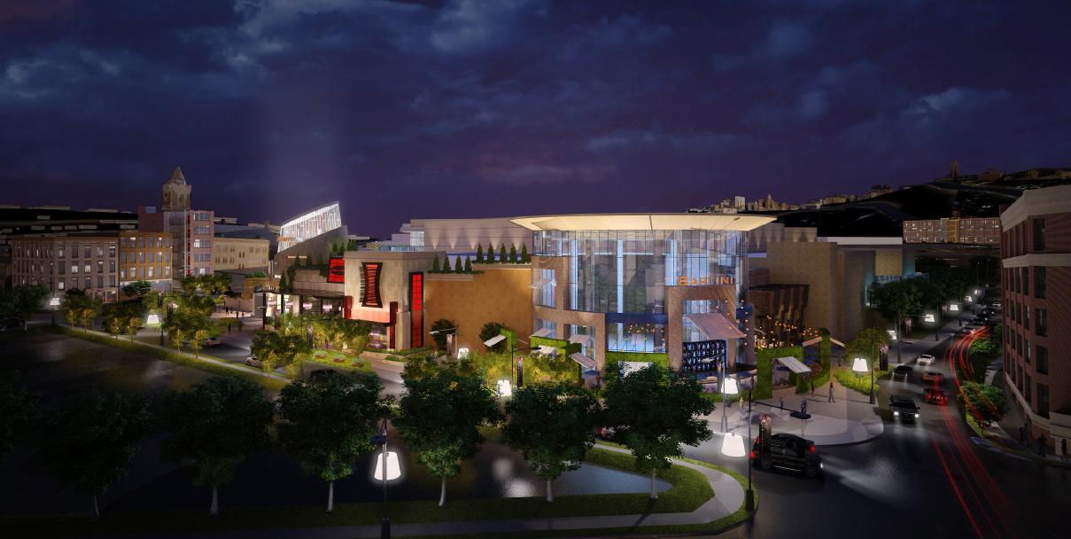
Cincinnati casino developers have selected Harrah’s Entertainment to operate the new casino to be built on Broadway Commons, and the city has approved the necessary funding to move forward on a new Broadway Commons district study that will include recommendations on design, policy, and programming for the newly developed area.
“We hope to integrate what the community wants to see there, and make sure their vision is realized,” said Stephen Samuels, President, Bridging Broadway. “We also hope to be strong allies with the development team as a big part of our mission has been to help see this development happen in a constructive manner amongst so many constituents.”
The casino plan includes a $400 million, 500,000 square-foot facility located on the 20-acre Broadway Commons site. Rock Gaming (formerly known as Rock Ventures) developers hope to start construction, on the casino, in late 2010 and entertain the first visitors by 2012. It is anticipated that the massive development will attract more than six million visitors annually, and create 2,800 jobs.
In the mean time, local leaders will embark on the Broadway Commons district study which will study the economics, transportation, urban design, and social issues faced within a half-mile radius of the project. The study will officially begin on Wednesday, September 1 and include a series of community dialogue meetings.
Samuels says that to achieve these goals, the non-profit group could use additional help from those in urban planning, architecture, consumer research, technology, construction, community outreach, and grant writing fields. Those interested in participating are encouraged to contact Stephen Samuels at stephen@bridgingbroadway.com.
“I am both confident and skeptical that we can achieve these goals with Rock Gaming,” Samuels explained. “I would not have spearheaded this effort had I not had any concerns, but so far the city and the developers have been great partners.”
In late June 2010, 18 individuals from Cincinnati made a trip to Nashville, TN in order to learn more about that city’s form-based code efforts. While on the trip, local officials and community leaders toured three of Nashville’s most notable developments to see first-hand how such land planning initiatives have made a tangible impact there.
The delegation attending the last of several trips to Nashville included Cincinnati City Councilmembers Laure Quinlivan, Charlie Winburn and Wendell Young; Hamilton Vice Mayor Rob Wile; leaders from Downtown, Walnut Hills, Mt. Auburn, Hyde Park, The Christ Hospital, the Cincinnati Form Based Codes Initiative, and UrbanCincy.
While in Nashville, the delegation visited Lenox Village and The Hill Center. The two new urbanist developments located in Nashville’s suburban communities each have a unique focus as Lenox Village offers a walkable residential neighborhood, while The Hill Center is an upscale commercial district built in a walkable manner.
Inside Lenox Village, the delegation was impressed by the development’s tree-lined streets, wide sidewalks, public gathering spaces, and pocket parks with homes ranging in cost from $84,000 to $350,000. The development also includes a small element of office and retail space, while also providing ten percent of its total housing units as rental.
The area surrounding the upscale, 220,000 square-foot Hill Center development reminded some of the Cincinnati guests of the Kenwood area. But while many of the same upscale retailers were found at both, the physical implementation is much different. According to the developers of The Hill Center, much of the difference comes in the “road diet” that took place to accommodate bicycles, improve sidewalks and pedestrian connections.
“Granbery described the “ping-pong effect” that retailers desire, where a pedestrian can easily cross from one side of the street to the other to reach another retail store that catches his or her eye – even green space should not be so wide as to keep shoppers from crossing the street easily,” described Cincinnati Vice Mayor Roxanne Qualls.
The third development the group toured was The Gulch which is a former railroad center turned mixed-use infill project adjacent to downtown Nashville. Restaurants, live music venues, trendy retail, and condominium towers now occupy the site which has become a popular destination for young people. The Cincinnati delegation also noted that the development project earned a LEED for Neighborhood Development (LEED ND) silver certification for its location, transit access, neighborhood design, green infrastructure and buildings, and its overall design process.
The Gulch is only the ninth neighborhood in America to receive such designation, and the first neighborhood in the south. Since the plan was originally developed in 2002 by MarketStreet Enterprises, the City of Nashville and Davidson County Metropolitan Development & Housing Agency have invested nearly $7 million in infrastructure improvements. The Gulch neighborhood has also required the incorporation of affordable housing in order to receive tax increment financing assistance. Within the ICON, 44 of the total 418 housing units are affordable to those earning 80 percent of median income for the area ($34,000 or less).
The trips to Nashville were taken to help further develop Cincinnati’s initiative to develop form-based codes throughout the city as neighborhoods desire. Should Cincinnati develop such a system of land planning it would become only the third major American city to do so joining Miami and Denver. If all goes according to plan, city officials hope to start implementing the necessary zoning code amendments by fall 2010 with the help of Opticos Design.
I am a native of the Greater Cincinnati area, but I have spent the better part of my adult life living and working in Chicago. I left Chicago in 2007 for greener pastures in New York City, and then ultimately found my way back home to Cincinnati earlier this year. However, I still look back on my time in Chicago as having an enormous impact on my thoughts about urban planning and design, architecture, and mass transit.
In June of this year, and after a long absence, I spent my first weekend in Chicago since becoming involved in discussions about Cincinnati’s ongoing urban renaissance. Once I arrived in town, I could not help but look at my old stomping grounds in a whole new light, and see Chicago’s urban development through the eyes of a born-again Cincinnatian. Over the course of a few days, I was able to explore a few key differences between the two cities, and perhaps come home with a few insights that can be applied to Cincinnati.
Urban Form:
The first and most obvious difference between Cincinnati and Chicago is one of sheer scale. While driving through Indiana on the way to Chicago from Cincinnati, the transition from rural cornfields to suburban sprawl (and its inevitable traffic jams) began while I was still a good 40 miles away from the Chicago Loop. Here in Cincinnati, 40 miles in any direction from Fountain Square would be considered far into the hinterland. Indeed, it is possible to find oneself in a relatively rural area in less than five miles from downtown Cincinnati, depending on the direction of travel.
Topography plays a large role, of course: the Cincinnati area’s steep hills prevent large-scale development in many areas, while the vast plains surrounding Chicago offer no such limitations. I see this as an advantage in Cincinnati’s favor: In addition to providing unique vistas and hillside neighborhoods that Chicagoans could only dream about, Cincinnati’s geographic setting allows for an easy escape to the country without having to drive through 40 miles of strip malls and traffic congestion (assuming one isn’t trying to escape via I-75 or I-71).
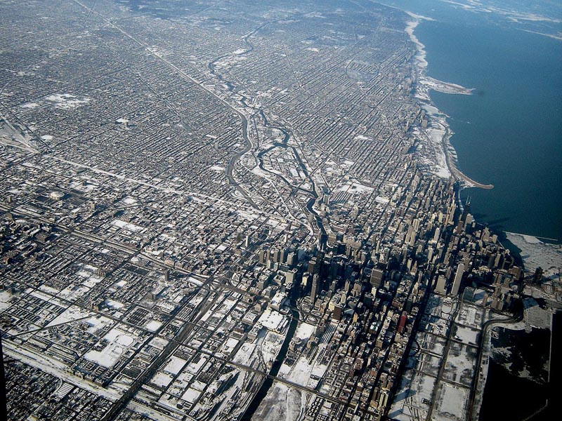
Chicago’s scale is apparent when flying into either of the city’s two airports, especially at night. Chicago’s relentless street grid stretches from horizon to horizon, with the radial streets and freeways all leading to the mountain of skyscrapers downtown. The city’s magnificent lakefront parks form an elegant transition from dense urban neighborhoods to the empty expanse of Lake Michigan. The entire city — so orderly and logical from above, like a circuit board — has the appearance of a vast machine. Down on the surface, though, the machine-like efficiency of the street grid leaves little room for quirks and eccentricities such as Cincinnati’s Mt. Lookout Square or O’Bryonville.
Commercial Districts:
Aaron Renn recently wrote a thought-provoking article about how cities treat their ordinary spaces versus their special spaces, and I believe Cincinnati has the edge in this regard. We don’t have the “special spaces” that Chicago has, such as a Magnificent Mile or a Grant Park (although that is changing for the better as Cincinnati develops its riverfront), but we have a vast number of unique “ordinary spaces” that each have their own character. For example, Chicago’s neighborhood business districts tend to be linear corridors along straight commercial streets, with relatively little distinction from each other. Aside from the makeup of the retail establishments, the urban space of Broadway in Lakeview isn’t much different from that of Milwaukee Avenue in Wicker Park or of Lawrence Avenue in Albany Park. Here in Cincinnati, even if you disregard the types of businesses that occupy the storefronts, there is a real difference between neighborhood business districts such as Ludlow Avenue, Hyde Park Square, and Over-the-Rhine.
Speaking of Over-the-Rhine, there is simply nothing like it in Chicago, as OTR was a bustling urban neighborhood when Chicago was still a remote trading post. Chicago’s present form didn’t come into being until after the Great Chicago Fire, by which time many buildings in Over-the-Rhine were already a generation old. For an urban neighborhood that comes close to resembling Over-the-Rhine, one must look east to New York or Philadelphia rather than west to Chicago.
Residential Neighborhoods:
If Chicago’s commercial avenues are rather drab, that city’s residential side streets offer many lessons for Cincinnati. Upon taking a turn down a leafy side street in Chicago, a pedestrian immediately enters a lush, green world where the noise of the city fades away and the harshness of the sunlight is filtered out by a dense canopy of trees, usually flanked by ornate row houses, bungalows, or apartment buildings. The importance of greenery cannot be understated, and as Over-the-Rhine continues its rejuvenation, Chicago shows that when it comes to street trees, there’s really no such thing as too many. It’s no coincidence that OTR’s Orchard Street — arguably the greenest street in the neighborhood — is also one of the most sought-after streets for renters and homebuyers.
Cincinnati’s dominant grocery store chain could also learn a thing or two from Chicago’s two largest chains on how to design and operate “big box” grocery stores that add life to urban business districts, rather than suck life from them. Throughout Chicago’s denser neighborhoods, Dominick’s (a division of Safeway) and Jewel (a division of Albertson’s) are building stores that place the main entrance at the corner of the building, facing a busy intersection, rather than behind an ocean of parking. In many cases, the stores are multi-story affairs with residential or commercial space above, and parking in a garage tucked around the corner.
An urban-scaled Dominick’s Store in Lincoln Park
One of the first such stores is a Dominick’s location at the corner of Fullerton and Sheffield, adjacent to a CTA rapid transit station and DePaul University. The ground floor of the store contains a deli, butcher and seafood department, florist, bakery, a Starbucks, and the checkout lanes, while the second floor contains aisles of groceries and general merchandise. Large-capacity elevators allow customers to transport strollers and shopping carts between the floors.
Up in my old neighborhood of Edgewater, a Dominick’s store at the corner of Foster and Sheridan — an older suburban-style store not unlike the Kroger store in Corryville — is being replaced with a modern store that respects the neighborhood rather than turning its back on it. If Kroger’s two largest national competitors, Safeway and Albertson’s, are tripping over each other to build urban-scaled grocery stores in dense neighborhoods, then Kroger’s claim that there is no market for such stores would seem to ring hollow.
Public Transit:
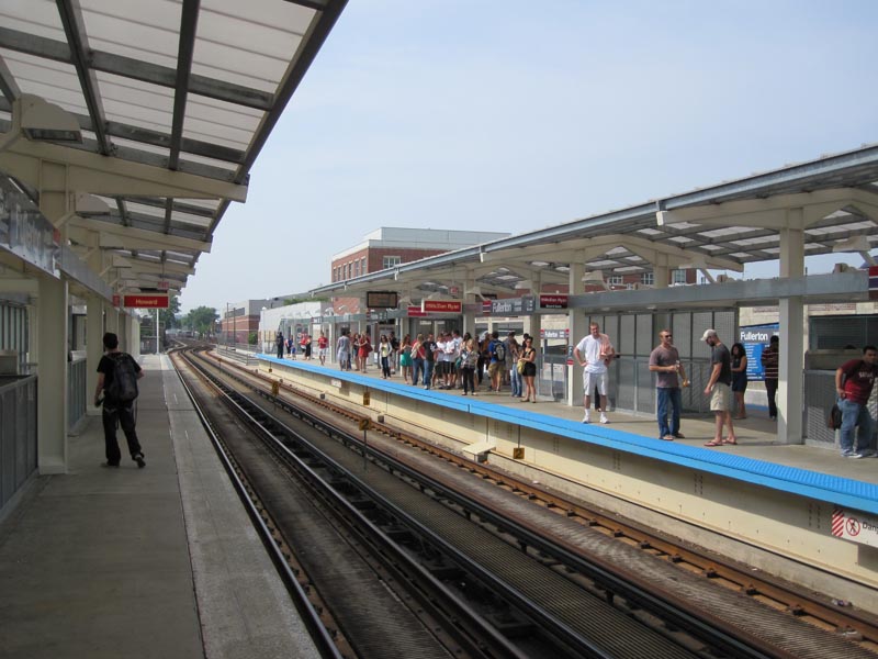
Another key difference between Cincinnati and Chicago that cannot be ignored is public transit. While Chicago’s system of public transit is not perfect by any stretch, Chicago has a culture in which taking a train to work or for shopping is simply accepted as a routine fact of life for most people, rather than as something that is done only because one has no other choice. There is no stigma, and a wide variety of demographic groups can be found represented on the city’s buses and trains on any given day. Regrettably, only a handful of American cities have achieved this, and Cincinnati is not yet one of them. To its credit, the Chicago Transit Authority has recently completed an ambitious upgrade of many stations on the city’s north side and west side, with further upgrades elsewhere in the city underway.
The newly-renovated CTA rapid transit station in Lincoln Park
Finally, and perhaps most importantly, is the difference in general attitude between the two cities. Chicago has a certain swagger that Cincinnati lacks, a confidence among the populace that the city is capable of doing great things and attracting great people. This is a double-edged sword, in that Chicago’s reputation of being “the city that works” involves a strong-man mayor who has almost unlimited powers, who can easily crush any community opposition to his plans.
Indeed, while certain Chicago neighborhoods are high-priced hotbeds for economic development, vast parts of the city continue to look as if they were imported from Detroit. There is also the corruption: In Cincinnati, it would be almost unthinkable for a City Council member or department head to be hauled away in handcuffs by the FBI and indicted on federal corruption charges. In Chicago, such occurrences happen often enough that they barely even make the local news.
Cincinnati, on the other hand, has a long-standing inferiority complex that has proven difficult to shake. But as major projects such as the streetcar, The Banks, and Central Riverfront Park are completed, perhaps Cincinnati will adopt a unique swagger of its own, while avoiding some of the pitfalls of our younger and larger neighbor to the north.
[This op-ed was originally published on The Urbanophile on July 13, 2010. Visit the original op-ed for more comments, thoughts and opinions on the matter of Cincinnati’s dramatic riverfront revitalization effort over the past two decades – Randy.]
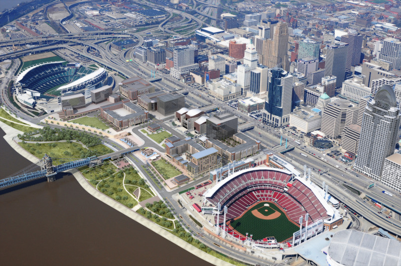
Several decades ago Cincinnati leaders embarked on a plan to dramatically change the face of the city’s central riverfront. Aging industrial uses and a congested series of highway ramps was to be replaced by two new professional sports venues, six new city blocks of mixed-use development, a new museum, a central riverfront park, and parking garages that would lift the development out of the Ohio River’s 100-year flood plain.
Paul Brown Stadium, home of the Cincinnati Bengals, was one of the first pieces of the puzzle to fall into place. The $455 million football stadium kept the Bengals in Cincinnati and has received national praise for its architectural design while also entertaining sold-out crowds.
The next piece to fall into place was the reconstruction of Fort Washington Way which consolidated the stretch of highway and opened up land critical for the construction of yet another stadium and the mixed-use development which became known as The Banks. The 40% reduction in size was not the only accomplishment though. The reconstruction project also included the Riverfront Transit Center designed to one day house light rail connections and a sunken highway that could be capped with additional development or park space.
Following the reconstruction of Fort Washington Way, Riverfront Stadium was then partially demolished to make room for the construction of the $290 million Great American Ball Park. Once complete, Great American Ball Park began entertaining baseball fans at 81 home games each year and at a new Reds Hall of Fame & Museum. The new venue eliminated any need for Riverfront Stadium and thus led to its implosion in 2002.
The removal of Riverfront Stadium then freed up room for the construction of the National Underground Railroad Freedom Center atop the first piece of a two-deck parking garage intended to both lift the new riverfront development out of the flood plain, and provide enough automobile parking to replace what was previously there in the form of surface lots and satisfy new parking demands created by the development.
The most recent piece of the puzzle has been the development of the initial phases of both the Cincinnati Riverfront Park and The Banks. The two separate projects are developing in complimentary fashion and are on similar time tables, and are both developing east to west from Great American Ball Park to Paul Brown Stadium. Recent news will add a modern streetcar line running through The Banks development that will transport people from the transformed riverfront into the Central Business District, Over-the-Rhine and beyond to Uptown.
The 45-acre, $120 million Cincinnati Riverfront Park is expected to become the crown jewel of an already nationally acclaimed Cincinnati Park System. The Banks meanwhile will bring thousands of new residents, workers and visitors to Cincinnati’s center city. The initial phase of both projects is expected to be complete in spring 2011 and will include 300 new residences, 80,000 square feet of retail space, Moerlein Lager House, Commuter Bike Facility, additional components of the two-deck parking garage, and the first elements of the park.
The transformation of Cincinnati’s central riverfront from aging industrial space to a vibrant mixed-use extension of downtown is not complete, but the two-decade old, $3 billion vision is finally nearing reality. And with full completion expected in the coming years, one of the remaining traces of Cincinnati’s industrial past will be replaced by a new vision for a 21st Century city and economy.
Plan Cincinnati will host two summer learning forums this month that will include information about local plans in place guiding the city’s new comprehensive plan, and what regional efforts are currently underway to help implement such initiatives.
The first of the two meetings will take place on Wednesday, August 4 in Corryville. This forum will include a panel made up of Larry Falkin from the Office of Environmental Quality, Terry Grundy from the United Way, Eric Rademacher from the University of Cincinnati, and Sam Stephens from the Department of Community Development.
The panel will engage in a moderated discussion of local plans and policies currently in place. Forum organizers say that the discussion will specifically focus on plans like GO Cincinnati, the State of the Community Report & Indicators, and Green Cincinnati that are seen as important factors helping to shape the comprehensive planning process currently underway.
The second forum will focus on regional efforts like Agenda 360, the award-winning Community COMPASS, 2030 Transportation Plan, and Strategic Regional Policy Plan developed by the OKI Regional Council of Governments. This forum will also include a moderated panel discussion made up by Todd Kinskey from the Hamilton County Regional Planning Commission, Robert Koehler and Emi Randall from OKI, and Mary Stagaman from Agenda 360. This forum on regional plans and policies is scheduled to take place on Thursday, August 26.
Cincinnati City Council is expected to vote on the completed comprehensive plan in 2011. Cincinnati was the first major American city to adopt a comprehensive plan in 1925, but it has been 30 years since the last comprehensive plan was completed and updated in 1980.
Both forums are will be held from 7pm to 9pm in the auditorium of the CPS Education Center in Corryville (map). On-street automobile parking, free bicycle parking, and Metro bus service (plan your trip) is available for this location.