Categories
News

UC’s Sustaining the Urban Environment named Advanced Energy Center of Excellence

Ohio Governor Ted Strickland recently announced the first round of Advanced Energy Centers of Excellence, and on that list was the University of Cincinnati’s Sustaining the Urban Environment (SUE) along with eight other centers across the state. The announcement comes after the SUE Center of Excellence won the National Science Foundation 2009-2010 Award for its “Economic Development through Green Entrepreneurship (EDGE)” initiative.

According to the University of Cincinnati, the prestigious honor will place the Sustaining the Urban Environment Center of Excellence in a leadership position for improving the health and wealth of Ohio’s urban residents through the development of technologies that promote the evolution of economically and environmentally sustainable urban regions.

According to the U.S. Census Bureau, more than 80 percent of the U.S. population lives within urban environments. These megacities and urban regions consume large amounts of natural resources to satisfy energy demands, and as a result, the SUE Center of Excellence (blog) has a goal to design for life and work in a manner that sustains the environment and resources for the benefit of present and future generations.

To accomplish this, the SUE Center of Excellence has developed partnerships with Cincinnati-area businesses to help identify potential sustainability solutions. The SUE Center of Excellence will also continue to study how urban infrastructure and environmental policies affect the long-term health and wealth of cities; and will continue examine scientific metrics, policies and technologies that, “promote the evolution of economically and environmentally sustainable urban regions.”

Categories
Development News Politics Transportation

Cincinnati installs dedicated bike lanes along Dana Avenue

In an aggressive attempt to improve upon the “C” grade received on its first-ever annual Bicycle Report Card, City leaders are looking at ways to incorporate bicycle facilities into the city’s larger transportation network. The most recent example can be seen along Dana Avenue in between Madison Road and Grigg Avenue (map) where the City incorporated dedicated bike lanes along a nearly one-mile stretch of roadway.

The stretch of Dana Avenue had at one point been bloated with unnecessary amount of vehicle lanes. As a result, the City took the opportunity to put Dana Avenue on a “road diet” when they began work repaving the road as a part of the City’s Street Rehabilitation Program.

New dedicated bike lanes along Dana Avenue – photos by Melissa McVay.

The road diet included the removal of two vehicle lanes and the addition of two striped, five-foot wide dedicated bicycle lanes. In instances like the Dana Avenue road project, City leaders saw it as a cost-effective way to quickly implement bicycle facilities without any disruption.

Cincinnati now boasts more than 8 miles of dedicated bike lanes throughout the city, with another 2.58 miles of sharrows along city streets. Another 340 miles of roadway is being studied as part of the Bike Plan process. Additional Street Rehabilitation and Transportation Design projects will also be evaluated during the design phase to see how bikes or pedestrians can be best included as well.

Categories
News Politics Transportation

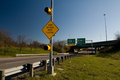
I-74 Ramp Meters are exactly what Cincinnatians asked for

It took less than one hour for the complaints to start rolling in about the new ramp meters along Cincinnati’s Interstate 74. Morning commuters complained that the meters were actually making congestion worse and that the slow downs were pushed onto the ramps and surrounding neighborhood streets leading to the interstate.

What many of these commuters probably do not realize is that ramp meters actually do not reduce congestion directly. Instead they diffuse congestion and reduce conflict points for drivers by eliminating much of the lane-to-lane merging that occurs around heavy on-ramp points.

The idea is simple, instead of having a slew of cars come rushing onto the interstate all at once, the ramp meters spread that surge out with a managed traffic flow. But what this does do is push congestion back off of the interstate onto the ramps and surrounding streets. That is unless other indirect things take place.

Ramp meters at Colerain Avenue along I-74 – photos taken by Jake Mecklenborg.

Improved traffic flow can improve capacity issues on interstates and thus reduce congestion. Well-timed and managed traffic systems surrounding interstate on-ramps that include these meters can also help avoid bottlenecks on neighborhood streets. But ultimately ramp meters do not reduce congestion for the simple reason that they do not add capacity or reduce volume.

The best way to reduce congestion along I-74, or any interstate, is to build additional capacity that does not strain the existing system. What this means is that simply adding a lane or two won’t do the trick, but adding a commuter light rail line will.

In Atlanta, the infamous “Downtown Connector” includes both I-75 and I-85 traffic and is currently in the process of being widened AGAIN. It too includes these ramp meters to manage traffic flow. Once the widening project is completed the stretch of interstate, appropriately compared to the Ohio River of Atlanta by the Carter/Dawson development team of The Banks, will boast some 24 lanes of automobile traffic including the intricate system of parallel ramps. The interstate still suffers from daily gridlock every day even with this monstrous automobile capacity because the same system is being strained to handle additional capacity while no new capacity is added to the overall transport network.

Ramp meters at North Bend Road along I-74 – photos taken by Jake Mecklenborg.

In Cincinnati, I-75 is being widened in most places throughout Hamilton County to 4 or 5 driving lanes not including ramps, and will also include these ramp meters at virtually every on-ramp location. With these improvements it has been identified that this stretch of interstate through Hamilton County will go from a “D” rated highway to a, wait for it, “D” rated highway once complete.

We are pouring billions of dollars into these interstate improvements and seeing little to no improvements in safety or congestion. A well-integrated commuter rail system that compliments our existing interstate and road networks is a much more effective way to manage traffic congestion. Such a system would provide additional capacity and options for commuters as they move from our region’s residential sectors to our region’s job centers.

So when you are enjoying that rush hour commute next time try to avoid letting the stress build up inside as you sit in the frustrating stop-and-go traffic. Instead be thinking about how the Cincinnati region could have been opening the first of 7 commuter light rail lines, two streetcar networks, and a completely revamped bus system had the 2002 Metro Moves plan passed. But instead of a long-term investment and solution we are stuck with temporary fixes that are wasting our tax dollars.

Categories
News Politics Transportation

It’s time to make rail transit reality in Cincinnati

With the resounding defeat of the terribly crafted Anti-Passenger Rail Amendment, the City may now move forward with its plans for developing a high quality transit network that includes rail transit in addition to buses, bicycles, pedestrians, and autos.

The Cincinnati Streetcar is one of those items, and within the project’s first phase will connect the two largest employment centers (Downtown & Uptown) for the Cincinnati-Middletown Metropolitan Statistical Area (MSA) with one another and with one of the largest potential housing reservoirs in the region (Over-the-Rhine).

The first phase of the system will start at the northern banks of the Ohio River at the multi-billion dollar development known as The Banks, run through the Central Business District and historic Over-the-Rhine, up the hill into Uptown and connect with the 40,000 student University of Cincinnati and nearby medical block.

Categories
News

Designing the way to a pedestrian success story

In a recent study conducted by Transportation for America, Cincinnati was ranked as the seventh safest city out of the nation’s 52 largest metropolitan areas. Cincinnati was the highest ranking Ohio city (Cleveland #10), and was the third highest ranking city in the Midwest behind Minneapolis (#1) and Pittsburgh (#4).

The study ranked cities based on a Pedestrian Danger Index (PDI) developed by Transportation for America. The PDI was formulated by dividing the average annual pedestrian fatality rate per 100,000 residents by the percentage of residents commuting to work on foot. The lower the PDI, the safer the city is for pedestrians.

The study showed a clear geographic divide between the safe and unsafe cities for pedestrians as the safest cities were located primarily in the northeast and Midwest, while the most dangerous cities were located in the southeast. Florida alone had the four most dangerous cities for pedestrians, with the rest of the top ten most dangerous cities all located in the south.

LEFT: Piatt Park in downtown Cincinnati. RIGHT: Calhoun Street in Clifton Heights.

This divide seems to indicate something many of us probably already knew – the fact that new growth areas are less hospitable to pedestrians due to their large urban scales that seem to be out of touch with the human scale. Northern cities that were largely built in the 18th and 19th Centuries feature smaller block sizes, narrower streets, and more compact developed when compared with their southern counterparts.

These design differences create a built in advantage for northern cities as they are much more capable of satisfying pedestrian commuters. But while northern cities boast nominally better rates of those commuting by foot, the real difference is in safety. For example, the second most dangerous city, Tampa, FL, has 3.52 deaths per 100,000 residents on average each year, whereas Cincinnati has a rate of just 0.77.

But what does all of this mean for Cincinnati? For a metropolitan area of 2,133,678 people that means about 21 pedestrians die each year. This number seems low, but it could still be improved upon, but the real area for improvement is the total percentage of people commuting to work by foot.

According to U.S. Census data, only 2.3 percent of the Cincinnati-Middletown Metropolitan Statistical Area (MSA) commutes to work by foot. New York City and Boston scored highest in this regard with 6 and 4.6 percent of commuters there walking to work respectively. But even in a more similarly built and sized city as Cincinnati, Pittsburgh boasts the third highest rate overall with 3.6 percent of their commuters making the daily grind by foot.

So if safety isn’t the issue in Cincinnati, then what is it? The region as a whole does not boast very dense development patterns outside of Cincinnati city limits and a few other pockets like Hamilton, Middletown, northern Kentucky’s river cities, and Norwood. Furthermore, the areas that are appropriately designed lack any clear amenities for pedestrians like crosswalk counters, scramble crossings at high pedestrian volume intersections, or curb bump outs. Another major detractor is the lack of barriers between pedestrians and motorists like bollards, trees/landscaping, or on-street parking.

LEFT: Purple People Bridge connecting Newport with Cincinnati. RIGHT: Vine Street in Over-the-Rhine.

I would also contend that the physical condition of our pedestrian surfaces is also a major factor. Fully taking advantage of the Federal Government’s Safe Routes to School program is a critical piece of the puzzle, but so is the ongoing maintenance of our pedestrian surfaces. This may be tricky in the low-growth Midwest and northeast, but solutions like rubber sidewalks provide long-term maintenance savings in addition to the overall improvement in surface quality for pedestrians.

It seems like a reasonable goal for the Cincinnati-Middletown MSA to strive for a 1 to 1.5 percent increase in the number of individuals commuting to work by foot. Old growth cities have been blessed by their design so far to have a natural advantage over new growth southern cities, but much more could be done to improve the designs of our modern transportation networks and our communities to make things even better for people in the nation’s 7th safest city for pedestrians.