Categories
News

Ohio facing ‘mobility crisis’ as transportation choices rapidly decline

Many people are aware of the dramatic cuts taking place at Ohio’s local transit authorities, but at the same time Ohio’s intercity public transportation modes – bus carriers, Amtrak, and airlines – are also seeing sharp service declines. According to All Aboard Ohio, these decreases in service are leaving many Ohioans stranded as they look for travel connections between Ohio’s many cities, towns, suburbs, and rural hamlets.

“Ohio is facing a serious mobility crisis,” said Bill Hutchison, president of All Aboard Ohio. “Ohio’s public officials and transportation company executives need to recognize a problem exists and start working together to address the lack of travel options.”

Intercity public transportation choices in Ohio. 1979 vs. 2009

The news comes out the non-profit’s new Transportation Report Card (pdf) in which the organization gave Ohio a “lump of coal” for the declining transportation choices. In the report, the following data illustrates that decline over the past 30 years.

  • Bus companies like Greyhound and Continental Trailways eliminated more than two-thirds of their Ohio departures and dozens of routes between 1979 and 2004;
  • In the past five years bus services have stabilized, but with some losses (Sandusky and downtown Dayton stops eliminated) and gains (Megabus adds Chicago service to Cincinnati, Cleveland, Columbus and Toledo);
  • Ohio has lost 1,000 route miles of Amtrak train service from 1979-2005 and saw service levels decline by 60 percent from 84 trains per week to 34;
  • Amtrak in Ohio has also stabilized since 2005 yet offers inconvenient middle-of-the-night services on just three routes;
  • Airlines have been in retreat after the attacks of Sept. 11, 2001, with Ohio airports losing seat-mile capacity ranging from 10-100 percent, mostly due to cuts in short-distance flights;
  • Losses accelerated since 2007 due to high fuel prices and the recession. Since 2007, airports in Ohio and within 100 miles of Ohio have seen their scheduled domestic departures decrease 7-39 percent.

According to All Aboard Ohio, these cuts have an especially negative impact on Ohio’s growing elderly population, disabled citizens, and lower- and working-class families who can not afford to own their own or reliably maintain their own car.

“Given the sorry state of intercity public transportation in Ohio, it’s probably better that you travel to grandma’s house this holiday season because it’s more difficult for her to visit you,” said Hutchison.

The U.S. Census Bureau estimates that Ohio residents over the age of 65 currently make up 16 percent of the state’s population – a number expected to grow to 20 percent by 2030. It is also estimated that in Ohio’s larger urban areas like Cincinnati and Cleveland, roughly 20 to 25 percent of the households have no car at all.

“While one can attribute this decline in transportation options to many factors, I believe it’s mostly due to complacency. Too many just blandly plod along and accept their fate without a fight. Well, we don’t accept it and this report is an early salvo in our fight.”

Categories
News Politics Transportation

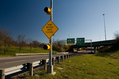
I-74 Ramp Meters are exactly what Cincinnatians asked for

It took less than one hour for the complaints to start rolling in about the new ramp meters along Cincinnati’s Interstate 74. Morning commuters complained that the meters were actually making congestion worse and that the slow downs were pushed onto the ramps and surrounding neighborhood streets leading to the interstate.

What many of these commuters probably do not realize is that ramp meters actually do not reduce congestion directly. Instead they diffuse congestion and reduce conflict points for drivers by eliminating much of the lane-to-lane merging that occurs around heavy on-ramp points.

The idea is simple, instead of having a slew of cars come rushing onto the interstate all at once, the ramp meters spread that surge out with a managed traffic flow. But what this does do is push congestion back off of the interstate onto the ramps and surrounding streets. That is unless other indirect things take place.

Ramp meters at Colerain Avenue along I-74 – photos taken by Jake Mecklenborg.

Improved traffic flow can improve capacity issues on interstates and thus reduce congestion. Well-timed and managed traffic systems surrounding interstate on-ramps that include these meters can also help avoid bottlenecks on neighborhood streets. But ultimately ramp meters do not reduce congestion for the simple reason that they do not add capacity or reduce volume.

The best way to reduce congestion along I-74, or any interstate, is to build additional capacity that does not strain the existing system. What this means is that simply adding a lane or two won’t do the trick, but adding a commuter light rail line will.

In Atlanta, the infamous “Downtown Connector” includes both I-75 and I-85 traffic and is currently in the process of being widened AGAIN. It too includes these ramp meters to manage traffic flow. Once the widening project is completed the stretch of interstate, appropriately compared to the Ohio River of Atlanta by the Carter/Dawson development team of The Banks, will boast some 24 lanes of automobile traffic including the intricate system of parallel ramps. The interstate still suffers from daily gridlock every day even with this monstrous automobile capacity because the same system is being strained to handle additional capacity while no new capacity is added to the overall transport network.

Ramp meters at North Bend Road along I-74 – photos taken by Jake Mecklenborg.

In Cincinnati, I-75 is being widened in most places throughout Hamilton County to 4 or 5 driving lanes not including ramps, and will also include these ramp meters at virtually every on-ramp location. With these improvements it has been identified that this stretch of interstate through Hamilton County will go from a “D” rated highway to a, wait for it, “D” rated highway once complete.

We are pouring billions of dollars into these interstate improvements and seeing little to no improvements in safety or congestion. A well-integrated commuter rail system that compliments our existing interstate and road networks is a much more effective way to manage traffic congestion. Such a system would provide additional capacity and options for commuters as they move from our region’s residential sectors to our region’s job centers.

So when you are enjoying that rush hour commute next time try to avoid letting the stress build up inside as you sit in the frustrating stop-and-go traffic. Instead be thinking about how the Cincinnati region could have been opening the first of 7 commuter light rail lines, two streetcar networks, and a completely revamped bus system had the 2002 Metro Moves plan passed. But instead of a long-term investment and solution we are stuck with temporary fixes that are wasting our tax dollars.

Categories
News Politics Transportation

It’s time to make rail transit reality in Cincinnati

With the resounding defeat of the terribly crafted Anti-Passenger Rail Amendment, the City may now move forward with its plans for developing a high quality transit network that includes rail transit in addition to buses, bicycles, pedestrians, and autos.

The Cincinnati Streetcar is one of those items, and within the project’s first phase will connect the two largest employment centers (Downtown & Uptown) for the Cincinnati-Middletown Metropolitan Statistical Area (MSA) with one another and with one of the largest potential housing reservoirs in the region (Over-the-Rhine).

The first phase of the system will start at the northern banks of the Ohio River at the multi-billion dollar development known as The Banks, run through the Central Business District and historic Over-the-Rhine, up the hill into Uptown and connect with the 40,000 student University of Cincinnati and nearby medical block.

Categories
News Opinion Politics

Cincinnati plans multi-million dollar surveillance camera system

The City of Cincinnati, in combination with the Uptown Consortium, has announced that 14 new high-tech surveillance cameras will be installed in various locations throughout Downtown (8) and Uptown (6). The cameras are being touted by local officials and community leaders as being a 21st Century crime fighting tool that should make Cincinnati a safer place.

The $19,000/piece cameras are not going to stop at this initial installation, that is expected to be fully operational within the coming months, as officials will have another dozen installed throughout East Price Hill and Westwood along Glenway Avenue by summer. An additional 12 to 15 cameras will be installed to monitor bridges, piers and waterways. Two years from now, officials hope to have 50 to 60 cameras installed across the city in other neighborhoods like Over-the-Rhine, Avondale, College Hill and Northside in addition to those in Downtown, Westwood, East Price Hill, Clifton Heights, University Heights, Fairview, Corryville and Clifton.

Public safety officials often proclaim that these types of cameras have the ability to deter crime and make neighborhoods safer, when in fact they don’t. Cameras simply move criminal activity around much like citronella candles keep bugs away from your backyard barbecue.

The cameras were paid for by a $2 million federal grant, but what about the ongoing maintenance? Who is going to watch the live video stream, or will someone? Who is going to review the tapes? What will be reviewed? What about archiving…how long, how much, where, and who manages it? What is the City going to actually do with all this information?

It would seem to be logical to assume that the primary use, for the cameras, will be for building cases against those who have already committed crimes. So, once again, how is this making the city safer? Instead it would seem that the cameras would just make prosecution more effective in some cases. But at the same time, I would imagine the criminals will be smart enough to see the bright white and prominently branded cameras and move their operations just outside the cone of view.

So then what, do we install more cameras…cameras on every street corner? Who will pay for that kind of an operation, and are Cincinnatians accepting of this Big Brother kind of a move? In New York they are in the process of installing some 3,000 cameras that will be fully operational by 2010. The costs of New York’s system is pegged at $90 million with a $25 million surveillance center in the project’s first phase in lower Manhattan.

The London Evening Standard just reported that even with London’s impressive array of more than 10,000 CCTV cameras, the most expansive system of its kind anywhere, that roughly 80 percent of crimes go unsolved. The $334+ million system not only is not solving the core issues surrounding the need for individuals to result to criminal behavior, but the system is not even showing effectiveness in the one area it is suppose to shine.

This approach to crime fighting seems to be a reactionary way to manage complex criminal behavior. More money should be spent on identifying the causes behind individuals resulting to criminal behavior, and how to address that. Instead what we’re doing is spending $2 million on a project that at best will put more non-violent criminals behind bars or at least through our legal system, and at worst, become cumbersome to manage and prove ineffective much like London’s advanced Big Brother system.

Categories
News

Designing the way to a pedestrian success story

In a recent study conducted by Transportation for America, Cincinnati was ranked as the seventh safest city out of the nation’s 52 largest metropolitan areas. Cincinnati was the highest ranking Ohio city (Cleveland #10), and was the third highest ranking city in the Midwest behind Minneapolis (#1) and Pittsburgh (#4).

The study ranked cities based on a Pedestrian Danger Index (PDI) developed by Transportation for America. The PDI was formulated by dividing the average annual pedestrian fatality rate per 100,000 residents by the percentage of residents commuting to work on foot. The lower the PDI, the safer the city is for pedestrians.

The study showed a clear geographic divide between the safe and unsafe cities for pedestrians as the safest cities were located primarily in the northeast and Midwest, while the most dangerous cities were located in the southeast. Florida alone had the four most dangerous cities for pedestrians, with the rest of the top ten most dangerous cities all located in the south.

LEFT: Piatt Park in downtown Cincinnati. RIGHT: Calhoun Street in Clifton Heights.

This divide seems to indicate something many of us probably already knew – the fact that new growth areas are less hospitable to pedestrians due to their large urban scales that seem to be out of touch with the human scale. Northern cities that were largely built in the 18th and 19th Centuries feature smaller block sizes, narrower streets, and more compact developed when compared with their southern counterparts.

These design differences create a built in advantage for northern cities as they are much more capable of satisfying pedestrian commuters. But while northern cities boast nominally better rates of those commuting by foot, the real difference is in safety. For example, the second most dangerous city, Tampa, FL, has 3.52 deaths per 100,000 residents on average each year, whereas Cincinnati has a rate of just 0.77.

But what does all of this mean for Cincinnati? For a metropolitan area of 2,133,678 people that means about 21 pedestrians die each year. This number seems low, but it could still be improved upon, but the real area for improvement is the total percentage of people commuting to work by foot.

According to U.S. Census data, only 2.3 percent of the Cincinnati-Middletown Metropolitan Statistical Area (MSA) commutes to work by foot. New York City and Boston scored highest in this regard with 6 and 4.6 percent of commuters there walking to work respectively. But even in a more similarly built and sized city as Cincinnati, Pittsburgh boasts the third highest rate overall with 3.6 percent of their commuters making the daily grind by foot.

So if safety isn’t the issue in Cincinnati, then what is it? The region as a whole does not boast very dense development patterns outside of Cincinnati city limits and a few other pockets like Hamilton, Middletown, northern Kentucky’s river cities, and Norwood. Furthermore, the areas that are appropriately designed lack any clear amenities for pedestrians like crosswalk counters, scramble crossings at high pedestrian volume intersections, or curb bump outs. Another major detractor is the lack of barriers between pedestrians and motorists like bollards, trees/landscaping, or on-street parking.

LEFT: Purple People Bridge connecting Newport with Cincinnati. RIGHT: Vine Street in Over-the-Rhine.

I would also contend that the physical condition of our pedestrian surfaces is also a major factor. Fully taking advantage of the Federal Government’s Safe Routes to School program is a critical piece of the puzzle, but so is the ongoing maintenance of our pedestrian surfaces. This may be tricky in the low-growth Midwest and northeast, but solutions like rubber sidewalks provide long-term maintenance savings in addition to the overall improvement in surface quality for pedestrians.

It seems like a reasonable goal for the Cincinnati-Middletown MSA to strive for a 1 to 1.5 percent increase in the number of individuals commuting to work by foot. Old growth cities have been blessed by their design so far to have a natural advantage over new growth southern cities, but much more could be done to improve the designs of our modern transportation networks and our communities to make things even better for people in the nation’s 7th safest city for pedestrians.