Categories
Business Development News

‘The Rhine’ examines what all the changes in OTR mean to long-standing residents

As Over-the-Rhine continues to be transformed, some have wondered if the changes taking place may have a negative impact on the low-income residents currently living in the neighborhood.

This was the fight Buddy Gray long fought for Over-the-Rhine until he passed in 1996. The door was then opened for a change to this dynamic in the early 2000s when the Cincinnati Center City Development Corporation (3CDC) was able to purchase hundreds of properties throughout the downtrodden neighborhood.

Since that time hundreds of new housing units and dozens of new businesses have opened up shop. While some of those new businesses and residents match those that have long called the neighborhood home, others do not, and instead present a stressful new reality for those low-income residents who are seeing their world change around them.

The following video, entitled The Rhine, was produced by Kyle Pedersen in an effort to highlight these struggles. UrbanCincy in no way taking a position on the contents of this video, but instead thought it would be useful as a point to start a conversation about the changes taking place in historic Over-the-Rhine.

What do you think? Are the differences between the new and the old residents of Over-the-Rhine too great? What, if any, opportunity is there to bridge that divide? Have investors done enough to engage the existing community? Is the existing community, and their representative organizations, overreacting? We would love to hear your thoughts and ideas.

Categories
Development News Opinion Politics

What’s the full story behind Cincinnati’s 50-year population decline?

Cincinnati, like all peer cities, recorded its peak population in the 1950 and has steadily lost residents since. Specifically, Cincinnati has lost 205,000, or 43 percent of its peak population of 503,998 as recorded by the U.S. Census Bureau. Meanwhile, the population of Cincinnati’s metropolitan statistical area has doubled to 2.2 million.

Contrary to the narrative perpetuated by those who practice the politics of decline, this loss of population is symptomatic not of variously corrupt or negligent city officials but is rather the outcome of social trends that have evolved well outside the purview of city government. What’s more, nationwide demographic trends and elevated living standards mean attracting 205,000 new residents would require the City of Cincinnati to transform itself physically into something entirely unlike what it is at present or was in 1950.


Cincinnati’s population has taken a recent downward trajectory, but there may be more to the story. Chart produced by UrbanCincy.

Demographic Changes since 1950
Entirely overlooked in the public discussion of city population decline is the end of the postwar “Baby Boom” which was enabled by the U.S. Food & Drug Administration’s (FDA) approval of oral contraceptives in 1960, and the U.S. Supreme Court’s legalization of abortion in 1973. Between 1960 and 1975, the number of annual live births in the United States fell from 4.25 million to 3.1 million.

An academic assessment of how the plummeting birthrate affected Cincinnati’s population could consume weeks of research. But the drop in family size, along with the proliferation of separations and divorces, means nearly all Cincinnati homes and apartment units that were occupied by large families in the 1950s are today occupied by fewer people.

So for Cincinnati to regain its lost 205,000 residents, the number of people residing in existing homes and apartment units must increase dramatically, and new construction must be populated at something higher than today’s prevailing density. With no reason to expect that Cincinnati’s birthrate will suddenly increase to that of impoverished countries, all population growth must come from the city’s suburbs or from outside the region. The wealthier the newcomer, the more living space they can afford. So paradoxically, the successful pursuit of top talent frustrates the task of fitting 205,000 new residents within Cincinnati’s existing city limits.

Loss of Residential Neighborhoods
Cincinnati’s municipal boundaries have not changed since it achieved its peak population in 1950, but thousands of prewar homes and apartments have since been replaced by non-residential structures. This means Cincinnati not only lost tens of thousands of residents for construction of expressways, light industry, and other purposes, but these properties are generally unavailable today for any effort to repopulate the city.

Cincinnati’s loss of residents and residential land was not limited to expressway construction and urban renewal projects. In the neighborhoods collectively known as Uptown, physical growth of universities, hospitals and other institutions has resulted in the demolition of over 1,000 homes and apartments since 1950.
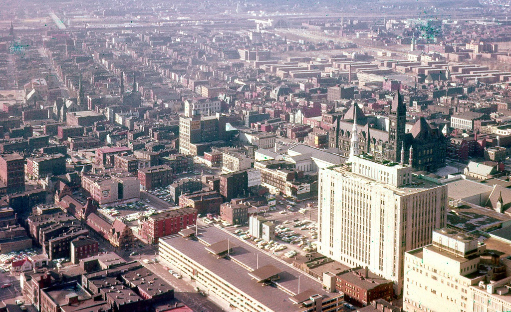

The West End, shown here in 1959, was demolished shortly after from 1960 and 1963 for Interstate 75 and the Queensgate industrial park. Photograph by Dave Tunison.

The Politics of Population Decline
A variety of unscrupulous local politicians and media figures cleverly play two sides of Cincinnati’s population loss narrative. According to them, Cincinnati has lost population due to high crime, high taxes, and corrupt city governance. But should the city start attracting new residents, the perceived “bad element” will be pushed outside city limits and into the areas of those trumpeting this false narrative.

Therefore, with every avuncular call for Cincinnati to improve itself, these figures work to undermine the city’s capital improvements, and have succeeded in creating a suburban culture that looks upon the city and those who support it with deep suspicion. What’s more, those who play the politics of decline know that Cincinnati cannot physically house 205,000 more residents without construction of dozens of hi-rise apartment blocks. Such apartment clusters and the subway system necessary to move their residents throughout the city would be met with excited accusations of “communism”.

Certainly, Cincinnati would benefit from new residents, especially in its under-populated neighborhoods where many historic structures are at risk of demolition. The arrival of 205,000 residents within the city limits would resolve many of the city’s current problems but would force higher apartment rents, increase noise and traffic congestion, and would motivate the demolition of historic structures for new multistory apartments and commercial buildings.

So while virtually every old American city has lost population within its city limits since 1950, some of that loss has occurred for reasons unrelated to the commonly heard decline narrative. Family sizes are smaller, non-residential buildings have been built in some former residential areas, and new neighborhoods have formed outside city limits to house those displaced by commercial and institutional growth. Considering these realities, the City of Cincinnati will likely never again be the home of 504,000 people, and so should not measure itself against its former peak population.


Categories
Up To Speed

New iPhone will expose Cincinnati’s lack of open data

New iPhone will expose Cincinnati’s lack of open data.

With the imminent introduction of the next generation iPhone from Apple, the new phone and iOS interface is poised to eliminate Google Maps in favor of Apple’s own mapping software package. The move, which will come by fall of this year, provides driving directions but relies on third-party applications to provide transit directions. The Southwest Ohio Regional Transit Authority (SORTA) is one of the top ten agencies that does not provide the necessary open data necessary to create a transit app to replace Google Maps. More from The Atlantic:

The strategy relies on a pretty big assumption, and third-party developers need open data to build these tools…Many cities still aren’t sharing their data, including big ones like Atlanta, Phoenix, and Detroit. Along with hundreds of other metros, these cities do provide their transit data directly to Google for use in Google Maps, using a standardized format Google developed known as the General Transit Feed Specification (or GTFS). Giving data to Google is not, however, what developers mean when they talk about “open data.”

Categories
Business Development News

Excess parking at Mercer Commons adding millions to project costs

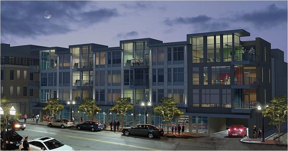
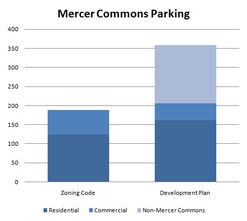
Project officials broke ground on the long-anticipated Mercer Commons project nearly one month ago. Once complete, the $56 million development will include 154 housing units, 26,000 square feet of commercial space, and a staggering 359 parking spaces.

Leading up to the project’s ceremonious groundbreaking, local preservationists had been concerned about Mercer Commons’ impact on the neighborhood’s historic fabric. But while much attention was paid to material treatment and exterior facades, not much was critiqued of the amount of parking.

According to the city’s zoning code, the development is mandated to provide one parking spot per residential unit, and one parking spot per 400 square feet of commercial space. Had the project merely followed what is prescribed in the city’s zoning code, then it would have had 161 fewer parking spaces.

The financial impact Mercer Commons’ parking is significant. 140 fewer spaces inside the new Mercer Commons Garage would have resulted in approximately $3.5 million in savings.

What’s more is that the portions of the Mercer Commons development along Vine Street qualify for a 50 percent parking reduction for being within 600 feet of a streetcar stop, thanks to a new regulation approved by the City of Cincinnati in June 2010.

Of the development’s 154 housing units, 30 of them will be affordable apartments which are likely to have occupants that cannot afford a personal automobile. Should you factor those two elements into the parking equation, then you would see the cost savings increase by approximately $750,000, bringing the total project cost down approximately $4.25 million.

The City has also recently considered eliminating minimum parking requirements in neighborhoods like Over-the-Rhine entirely.

“Although Over-the-Rhine is a walkable community, and the streetcar is coming, parking still needs to be addressed for residents, tenants and visitors,” explained Anastasia Mileham, Vice President of Communications with the Cincinnati Center City Development Corporation (3CDC) explained.


The $56M Mercer Commons development will include 154 residential units, 26,000SF of commercial space and 359 parking spaces once finished. Rendering provided.

According to 3CDC officials, some of the additional parking is there to support existing commercial retail in nearby developments that lacked enough parking when they were originally built, and that the parking lot at Twelfth and Vine, Valet Parking, Washington Park Garage, Mercer Commons Garage and future small lots and parking spaces are all considered in future planning efforts.

Mileham also says that their development corporation is also working with city officials to designate specific parking meters as residential only.

“We have gotten some complaints about parking, but when we gathered community input about Mercer Commons, parking was expressed as a need,” Mileham clarified.

The new above-ground parking garage is part of the first of three phases of development at Mercer Commons, and is expected to open in March 2013.

Categories
Up To Speed

Brookings Institution reports that far too many Cincinnati jobs lack transit access

Brookings Institution reports that far too many Cincinnati jobs lack transit access.

A new report from the Brookings Institution reinforces what UrbanCincy reported on 10 months ago. According to the report, 41 percent of the Cincinnati region’s jobs are in neighborhoods completely devoid of public transit. What is perhaps even worse is that the report finds that more than three-quarters of Cincinnati’s working-age population cannot reach a typical job in under 90 minutes. More from the Cincinnati Business Courier:

Businesses must be more aware of public transit service when they decide where to locate, and regions must look at other ways to link suburbs where a growing number of jobs are located…That’s especially important here, where the region has developed major centers of commerce in outlying counties such as Boone in Kentucky and Clermont and Butler in Ohio, said Mark Policinski, executive director of the OKI Regional Council of Governments transportation planning agency.