Categories
Development News Transportation

Elm Street Cycle Track Would Provide Critical Link for Region’s Bike Infrastructure

The city will start construction on physically separated bike lanes along Central Parkway, from Downtown to Clifton, this coming spring. Following a community engagement process, a final design was selected in recent weeks, and the large addition to Cincinnati’s bike network is expected to make a significant impact.

Not only will it be one of the most impressive bike facilities installed in the region to-date, but it will also link neighborhoods together that have large percentages of bicyclists. Furthermore, it will link other bike facilities with one another, and come close to linking even more.

Some of the existing facilities include numerous bike lanes and the Mill Creek Greenway, but the Central Parkway bike lanes will come about 12 blocks shy of connecting with the Ohio River Trail, which then links to the Little Miami Scenic Trail.

A two-way cycle track should be built in order to connect the new Central Parkway bike lanes with the Ohio River Trail and beyond.

Elm Street Cycle Track

There are two streets that connect from Central Parkway to the Ohio River Trail along Mehring Way without interruption: Main Street and Elm Street. Both of the streets have one-way traffic heading northbound, but Main Street is considerably more congested with cars and buses heading to Government Square.

Elm Street, however, has some of the least congestion of any north/south street in the Central Business District and could easily connect the Central Parkway cycle track with the Ohio River Trail. A reorganization of the street would need to occur however.

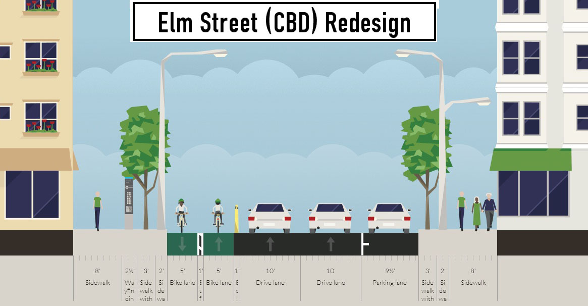
Presently Elm Street, from Central Parkway to Mehring Way, lacks consistency in its design with on-street parking located haphazardly along both sides of the street. A reconfiguration of the street could consolidate all on-street parking to the east side of the street, thus eliminating only a nominal number of on-street parking spaces, and maintain 2 to 3 moving traffic lanes (the parking lane could be restricted during rush hours to allow for a third travel lane).

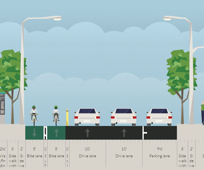
The Elm Street cycle track, meanwhile, would be located along the west side of the street and be buffered from moving traffic by a row of bollards. Such a redesign of Elm Street would be a bit of a road diet, but one that seems reasonable for this stretch of overbuilt roadway.

Planners with the City’s Department of Transportation & Engineering (DOTE) said that the idea of an Elm Street cycle track had not come up before, and has not been presented to any formal committees or community councils to-date. Such coordination, they say, would need to take place prior to the idea moving forward.

With future phases of The Banks and the yet-to-be-named residential tower on Fourth Street set to begin construction soon, there seems to be an opportunity to rebuild this roadway along with those projects. This would help offset some of the costs and make for a more seamless transition.

Projects like this are low-hanging fruit for the new mayor and council, should they wish to pursue investments that improve the city’s bike infrastructure. They should work with the bike community and come up with a strategy that provides a clear path forward to make this happen.

An Elm Street cycle track like this would provide a critical link in the region’s bike network, make the street safer, more accommodating to more users and more attractive to those who currently find themselves along the now bleak and desolate stretch of roadway. Let’s get to work.
Categories
News Opinion Politics

Mayoral Election Will Impact Cincinnati’s Planning Future

Cincinnati is in the midst of revitalization. There have been several significant accomplishments achieved since 2007 when the city’s Planning Department was reconstituted. Initiatives such as Plan Cincinnati and the development of Form-based code have united regional leaders and communities to help build a shared vision of the city’s future.

These efforts could be affected drastically with the election of a new mayor on November 5th.

Qualls: Focus on vision and and consensus building:
In her time as Mayor in the 1990’s and when she returned to City Council in 2007 Roxanne Qualls (C) has been the leader in implementing a bold vision for Cincinnati through planning policies. In the 1990’s, Qualls lead the effort to narrow Fort Washington Way which allowed for the expansion of downtown and the conversion of the riverfront into a showcase for the city.

The award winning Banks Master Plan owes its existence and implementation to Qualls’s dedicated leadership in establishing the Riverfront Steering Committee which developed the plan. By the time Qualls returned to council the plan had advanced through Mayor Mark Mallory (D) who formed The Banks Working Group and began implementing the plan in 2008.

Qualls has also been active in developing Plan Cincinnati, the city’s recently adopted comprehensive plan. But since her return on council she has been more closely associated with bringing form-based codes to Cincinnati.

Since 2007 she has led several groups on tours to Nashville, TN and Columbus, OH to learn more about form-based codes and how they benefit cities. Last month, that vision became reality when Madisonville became the first city neighborhood to adopt the form-based code regulating plan.

The Cincinnati form-based code is a comprehensive land use regulation that was developed by the city through years of community participation. It is a code that emphasizes that new development be constructed in a form that integrates into the traditional character of the neighborhood.

Cranley: Focus on removing barriers for developers:
Running against Qualls is former council-member John Cranley (D) who served on council from 2001 to 2009. He resigned from council in 2009 to pursue building a private development in East Price Hill.

The Incline Square project, located next to the Queens Tower apartment building, was envisioned to have a 22,500 square-foot office building be constructed along with a 58-unit four-story apartment building and restaurant space. Only the residential and restaurant portions of that development were built.

A review of Cranley’s track record on council had shown that early in his council career, he had been an advocate for making the city more “developer friendly.” In 2002, he was instrumental as chairman on the Budget & Finance Committee in dissolving the city’s long standing Planning Department, the oldest continuously running planning division in the country at the time.

The dissolution came over disagreements between the Planning Department and a developer in Oakley for the Center City of Cincinnati development. The unprecedented move generated a good amount of public outcry.

In 2002 Cranley told the Cincinnati Enquirer, “”The Planning Department was almost given the mission of causing problems, because it was completely divorced from economic incentives and any kind of market reality.”

However; Cranley did not oppose Mallory’s effort in 2007 to reestablish the department. He also signed a motion with Qualls on advancing form-based codes in 2008, but at a recent mayoral debate sponsored by the Urban Land Institute, Cranley strongly opposed them. He has also stated his opposition to planning and zoning, stating that the solution to neighborhood problems is money.

The outcome of this election will determine the future vision and progress of Cincinnati. That vision of progress is either one forged on grand visions and community outreach or one that favors minimizing regulations and oversight to increase development in the city.

Categories
Up To Speed

Free Sunday Parking viewed as somewhat problematic with renegotiated Chicago parking deal

Free Sunday Parking viewed as somewhat problematic with renegotiated Chicago parking deal

Chicago Mayor Rahm Emanuel today announced that he and the city’s finance and legal has settled a legal dispute with Chicago Parking Meters (CPM) that will provide for free parking in Chicago neighborhoods on Sundays and the introduction of a pay-by-cell option. The legal dispute originated over closed, added parking spaces or changes to periods of stay, hours of operation or parking rates and an estimated $1 billion in future charges over the life of the contract that would no longer be owed. Free Sunday parking is an issue many downtown Cincinnati businesses outside of The Banks have been arguing against, especially during Sundays with sporting events as they claim they can’t open their doors due to the lack of available metered parking. More from Streetsblog:

The proposed changes seem to be a good thing for the city overall, but the introduction of free Sunday parking is somewhat problematic. While I don’t have a problem with churchgoing seniors getting a break at the expense of people out on the town at night, free daytime parking in neighborhood retail districts could have unintended negative consequences.

On-street parking works best when its cost reflects the demand for spaces. When meter prices are steep in high-demand areas, it discourages people from parking in the same spot for long periods, which increases the chance that there will be open spots for short-term parking. When parking is free, it encourages visitors to park for longer periods, and it tempts employees to drive instead of walking, biking or taking transit to work. Their cars might occupy spaces all day, eliminating spots for potential customers.


Categories
Business Development News

Cincinnati Central Riverfront Plan wins national award for excellence

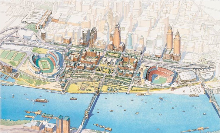
In 1997 officials from the City of Cincinnati and Hamilton County set out on a path to transform the city’s central riverfront. What became known as the Cincinnati Central Riverfront Plan laid out a bold vision to accomplish just that, and has now been recognized by the American Planning Association (APA) for the implementation of the plan first laid out nearly two decades ago.

The APA will present local leaders with the National Planning Excellence Award for Implementation at its annual conference to be held in Chicago on April 16.

“The Cincinnati Central Riverfront redevelopment is an excellent example of plan brought to reality,” Ann C. Bagley, 2013 APA Awards Jury chair, stated in a prepared release. “The fact that this development happened during an economic downturn demonstrates the strength of the plan and the importance of the public commitment that brought it into being.”


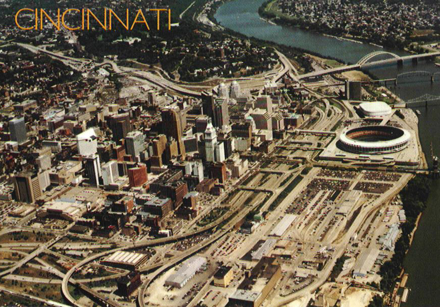
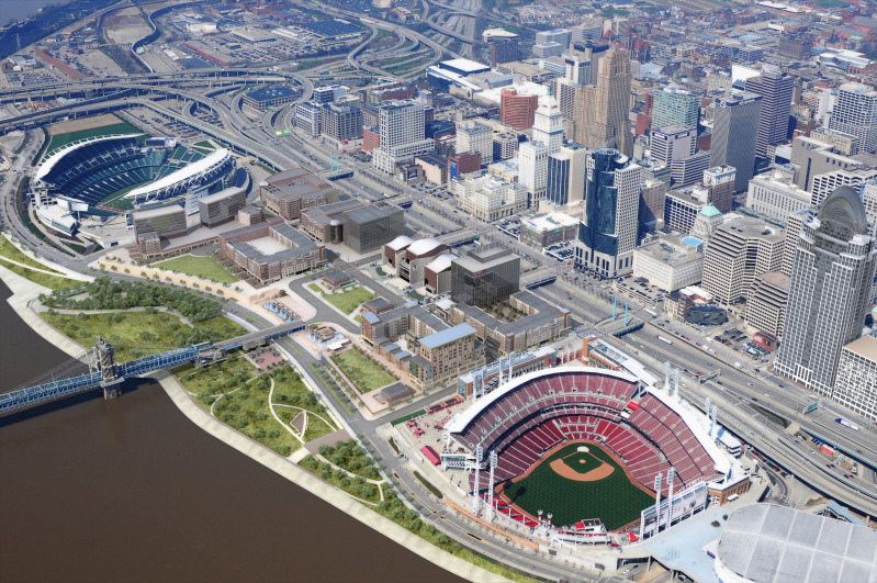
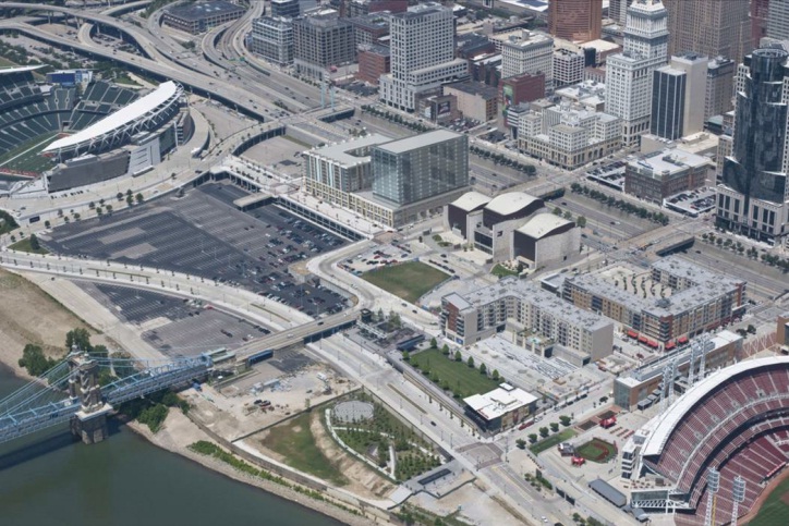
Cincinnati’s central riverfront has shifted dramatically from its form in the 1980s [LEFT], to that of the 2010s [RIGHT].

Local leaders have taken an incremental approach towards implementing the vision laid out in the Cincinnati Central Riverfront Plan. Between 1998 and 2002, the first major investments included the reconstruction Fort Washington Way (FWW), and the development of Paul Brown Stadium, Great American Ball Park, and the National Underground Railroad Freedom Center.

The consolidated FWW opened up dozens of acres of waterfront property, and the development of two stadiums and a major museum were intended to serve as cultural and entertainment anchors that would draw Cincinnatians back to the riverfront.

These significant public investments laid a critical foundation that would enable the next phase of work, historically located in one of the most flood-prone areas of the city, out of the 500-year floodplain.

Once a private development team had been selected, the City of Cincinnati and Hamilton County began to work with Carter-Dawson on the construction of the plan’s most ambitious element known as The Banks.


Phase two of The Banks will deliver another 300 residential units along with more than 60,000 square feet of commercial space, and a future office tower.

The $91 million first phase of the mixed-use development began in 2007 and resulted in 300 apartments, 76,000 square feet of commercial space, and 6,000 structured parking spaces. Emboldened by the success of phase one, developers are set to break ground on phase two in the coming months which will include another 300 residential units and more than 60,000 square feet of commercial space.

Two office towers, a hotel and townhomes are still to come within the first two phases of The Banks. At ultimate build out, officials envision The Banks to result in $600 million worth of private investment and become the home for more than 3,000 residents.

Meanwhile, construction of the $120 million, 45-acre Smale Riverfront Park is progressing concurrently with the development of The Banks. To date, the first phase of the new central riverfront park has been completed and work is beginning on phase two. Future phases will be timed with future construction of The Banks, and as funding is allocated.

“In planning terms, a project that goes from a concept to implementation in less than 20 years is impressive to say the least,” stated Todd Kinskey, Executive Director of the Hamilton County Regional Planning Commission. “It is that much more impressive because, in this case, the implementation involved seemingly insurmountable physical, economic, and political barriers.”

The early discussions surrounding The Banks, however, were tumultuous at best as local leaders grappled with complaints about too much office space being introduced into an already competitive marketplace.


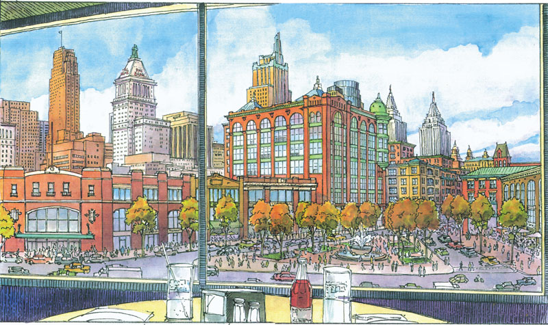
The original vision of the Cincinnati Central Riverfront Plan [LEFT] included more traditional types of architecture with greater use of natural building materials [RIGHT].

“The current plan to include 30-story buildings along the riverfront would harm downtown and violate the riverfront plans adopted by the community many years ago,” then Councilman Jeff Berding (D) told the Business Courier in 2007. “We need to remember that the plan adopted several years ago was not simply pulled out of the air, but was the result of intense public input and driven by professional urban planners.”

While design elements may not be of the same caliber as those originally envisioned, the urban form of the private investment appears to be as desired. But even more gratifying than that, for many of the early people involved in the planning, it is that the project has happened against all odds and skeptics.

“The successful implementation of the plan is the result of unprecedented cooperation between the city, the county and their partners,” exclaimed Vice Mayor Qualls (C), who was one of the original driving forces behind the development of the Cincinnati Central Riverfront Plan.

Her thoughts were further validated when Bagley concluded, “The fact that this development happened during an economic downturn demonstrates the strength of the plan and the importance of the public commitment that brought it into being.”

In addition to the future phases of the Smale Riverfront Park and The Banks, city leaders are now soliciting ideas for how to cap a 300-foot span of FWW. City and county officials say that the work to cap the short stretch of interstate will commence once a design is in place, and funding has been secured.

In 2010, UrbanCincy published an exclusive threepart series profiling the dramatic transformation of Cincinnati’s central riverfront over the past two decades.

Categories
Arts & Entertainment News

‘Cincinnati From Devou Park’ captures new urban b-roll for Queen City

Every so often the UrbanCincy team strolls through the interwebs to find out what kinds of video content people are producing about Cincinnati in the digital age. It turns out that the overwhelming majority of that content is commercial in nature, but every once in a while we find some good old fashion urban b-roll.

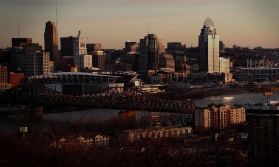
One of the most recent items we came across is Cincinnati From Devou Park by Michael Toffan. The nearly three-minute video slowly pans about the views from one of the region’s most popular vantage points. It is a slow and methodical video set to the song ‘Every Woman’ by Stephan Baird.

The video expectedly captures the views of downtown Cincinnati and Covington, but it also intimately showcases ongoing construction at The Banks (0:33), the aging Brent Spence Bridge (0:53), and barge traffic on the Ohio River (2:05).