Categories
Up To Speed

The dirty truth behind transit park and rides

The dirty truth behind transit park and rides.

Following the decade-long debate over the first phase of the Cincinnati Streetcar, the region seems to be back on-board with the idea of regional transit. Heck, even The Enquirer is hosting regular visioning sessions about regional transit these days. As an updated regional plan is developed, let’s be wary about the purported benefits of large park and ride stations touting their “free” parking. More from streets.mn:

In Minneapolis, we’re lucky to have anything more than a sign at our transit stops. We have plenty of room for improvement for our local service. But we instead choose to binge on ridership growth on the fringe, no matter how much money it costs us to “buy” those riders. Yet there are opportunity costs: For less than the cost of two Maplewood park & rides serving up to (2×580=) 1160 parked cars, we’re building a full Arterial BRT line on Snelling Avenue scheduled to open next year. Those improvements will serve an estimated ridership of 8,700. And, unlike additional parking spaces, these amenities serve all riders (not just the 3,000 new ones). This is 7.5 times more productive than the same investment in parking.

It’s not wise for our transit strategy to attract ridership at all costs by subsidizing car storage. Nor is it fair to transit riders who, by their own choice, pay the same fare but do not consume the same expensive parking spaces.

Categories
News Politics Transportation

What would moving Hamilton County BOE mean for those without cars?

Unsurprisingly, Ohio Secretary of State Jon Husted (R) has sided with his fellow Republicans in Hamilton County and cleared the way for Hamilton County’s Board of Election offices to move from Downtown to Mt. Airy. The ruling came as a result of the Hamilton County BOE’s deadlocked vote on the matter, which went along party lines.

Such a move will not happen for several years, but when it does it will make Hamilton County the only urban county in Ohio without its election offices located in its downtown.

Democrats seem to fear that the move will make early voting more difficult for the tens of thousands of residents who do not own a car. Republicans, on the other hand, seem giddy with the prospect of the new site being surrounded by an abundance of “free” surface parking options.

So what would the move mean for those living without a car in Hamilton County? In short, it would make voting a lot more difficult – especially for those in the eastern part of the county. It would also mean that the elections office and lone early voting location for Hamilton County would be moving further away from the population center and where most people work.

Those coming from the transit center at Anderson Towne Centre would see a four-hour round-trip, if they made all of their transfers seamlessly and nothing ran behind schedule. Those in the center city, the most densely populated area in the county, would need to block out several hours to account for the two-hour round-trip journey from Government Square.

If you are trying to get to the new Mt. Airy location from the Glenway Crossing Transit Center, Uptown Transit District or Kenwood Towne Center, your travel time would largely remain unchanged. That is if those people lived within a close walk to those transit centers like those near Government Square. The reality is that each of those three areas are much less walkable and would take considerable time accessing on their own right, thus adding significantly more time to the journey.

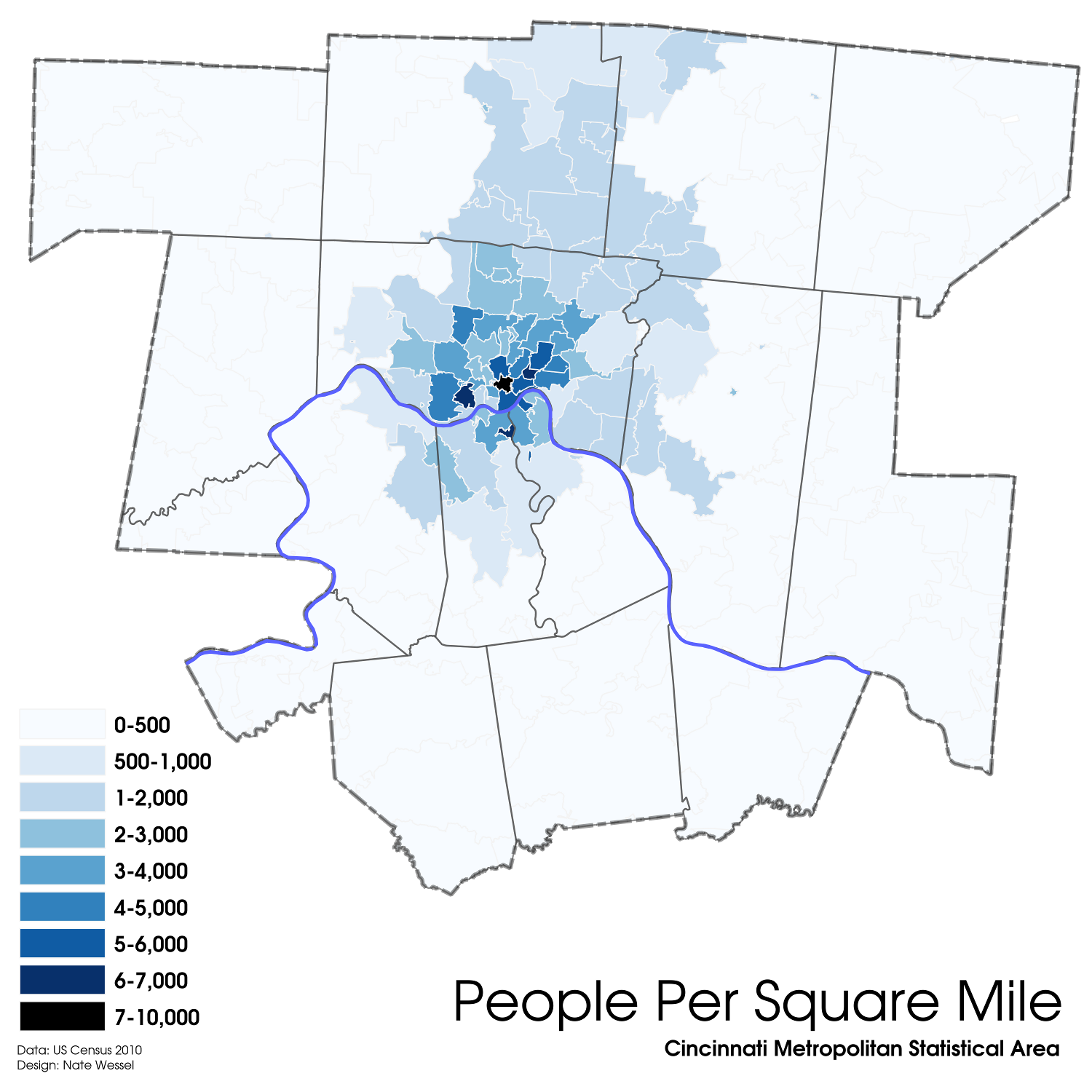
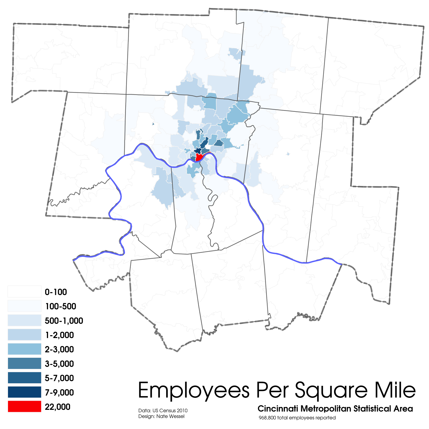
Cincinnati Population Density Cincinnati Employment Density

Should Greg Hartmann (R), Chris Monzel (R) and Alex Triantafilou (R) move forward with this it will in fact make the elections office and lone early voting location more accessible for those with cars in the western and northern parts of Hamilton County. It would also, however, make it less accessible for those with cars in the central and eastern parts of the county, and also worse for those without a car at all.

What is troublesome is that those with a car have access to the existing site. Yes, they may have to pay to park, but that is a minor inconvenience that absolutely must be weighed against creating hours-long journeys for those without a car.

The burden would be shifted to those who already have the least in our community. We hope Hartmann, Monzel and Triantafilou realize this would be morally wrong and decide to keep non-back office and early voting operations of the Hamilton County Board of Elections downtown.

Categories
News Transportation

INFOGRAPHIC: The Abandonment of Cincinnati’s 1914 Subway and Rapid Transit Loop

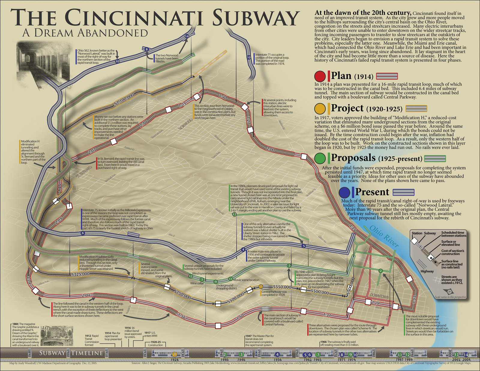
Cincinnati’s abandoned rapid transit project is a subject of continual interest. Although many are familiar with the unused two-mile tunnel beneath Central Parkway, little remains of the ten miles of surface-running right-of-way built in the mid-1920s between Camp Washington and Norwood.

This graphic by Andy Woodruff, from the UW-Madison Department of Geography, illustrates which sections of the so-called Rapid Transit Loop were built, which parts were replaced by expressways, and which parts were planned but not funded and built.

Cincinnati Subway System

So why was the Rapid Transit Loop started but not completed?

The project had several forces working against it, especially wealthy Downtown landowners who stood to lose money and influence if the city’s most valuable property shifted from Fountain Square north to Central Parkway. The likelihood of that happening was heightened by the Rapid Transit Commission’s decision to forego construction of the Walnut Street Subway as part of the project’s first phase.

Those who owned property lining Central Parkway knew that construction of a tunnel under Mt. Adams, linking the Loop’s never-built eastern half, would likely cost less than construction of the Walnut Street Subway and cause the loop’s traffic to bypass the city’s established epicenter entirely.

The second interest acting to scuttle the subway project was the consortium of seven steam railroads that commenced construction of Cincinnati’s spectacular Union Terminal in 1929.

An ancillary feature of the Rapid Transit Loop was its intention to serve the area’s electric interurban railroads at a multi-track terminal centered beneath the intersection of Race Street and Central Parkway. The interurban terminal’s more convenient location promised to erode the redundant services of the steam railroads.

Editorial Note: In addition to focusing on UrbanCincy’s transportation coverage, Jake authored a book about Cincinnati’s infamously abandoned subway and rapid transit project. First published in 2010, Cincinnati’s Incomplete Subway: The Complete History is considered to be the most comprehensive analysis of the events leading up to and after one of the city’s most notorious missteps.

Categories
Up To Speed

What is the future of cities where driverless cars rule?

What is the future of cities where driverless cars rule?.

I met Jonathan Geeting in Salt Lake City during the Congress for the New Urbanism annual conference. We were roommates during which we both participated in a training session led by Streetsblog, for which UrbanCincy is a long-time partner, and studied the city’s transportation while also taking part in the conference. During that conference Jon also filed daily reports for Next City, and has become an increasingly popular writer there.

Jon’s latest piece, which is quite excellent, is this week’s feature story, and it examines what a not-so-distant world might be like for cities when driverless cars are the norm. What might it mean for jobs, parking supply, sprawl or mobility, and when might it all come to fruition? Some of the possibilities may surprise you. More from Next City:

The driverless, or more accurately, self-driving car is widely predicted to revolutionize mobility by knocking humans out of the driver’s seat as soon as 2030. The technology offers the possibility of infinitely safer travel. Human error — a mistimed turn, a heavy foot on the gas pedal or any one of countless other driver mishaps — caused or contributed to more than 90 percent of car collisions, according to a landmark study done by Indiana University. With automated acceleration, braking technologies and crash-avoidance technology, driverless cars could make highways exponentially less deadly.

Yet there is another opportunity at stake: The chance to dramatically reshape the relationship between public space and the car. For the last 100 years, urban planners have designed cities to accommodate personal vehicles. Every home comes with a driveway or curb for your car. Asphalt seas of parking spaces or costly multistory garages surround schools, shops and office buildings like carbon-spewing moats. What if instead of driving our own cars, we relied on 21st-century carpools — sharable autonomous vehicles?

Categories
Business News Politics Transportation

CHART: The Best and Worst States in America for Transit Funding

According to data from the Federal Transit Authority (FTA), the State of Ohio provides some of the least amount of funding for its regional transit authorities of any state in America.

Texas, Georgia and Missouri also provide next to nothing to their various regional transit agencies, but in no other state are transit agencies as reliant on fares and local taxes as they are in the Buckeye State.

When broadening the search to examine transit agencies in the biggest cities across America, it also becomes clear that states like Pennsylvania, Utah and Maryland, Minnesota and Massachusetts invest large amounts of state dollars in transit. Some transit agencies with little state support, however, receive larger sums of money from regional transit taxes and federal aid.
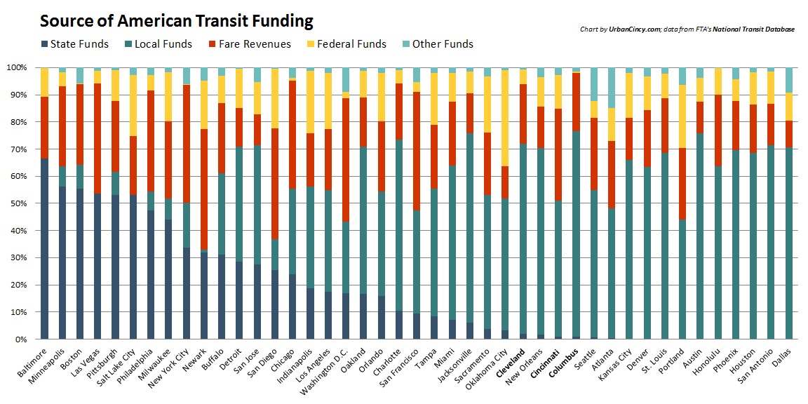
Source of American Transit Funding

Ohio’s three largest metropolitan regions – all with more than two million people – are different in this regard and have the least diverse range of financial support of transit agencies nationwide. For both Columbus and Cleveland, it means that well over 90% of their total revenues come from fares and local tax dollars, while in Cincinnati it is slightly better at 84% thanks to a bit more federal aid.

“In the recession we saw transit service cut while gas prices drove transit demand to record levels,” stated Akshai Singh, an Ohio Sierra Club representative with the advocacy organization Ohio for Transportation Choice. “Roughly all of the state’s public transportation funding now goes to operating rural transit services.”

Honolulu is the only other region in the United States that has 90% or more of its funds coming from just fares and local tax dollars. Cities in other states providing next to nothing also approach this threshold, but do not exceed it as is the case in Ohio.

It recently reported that the Southwest Ohio Regional Transit Authority (SORTA) is one of the best stewards of limited financial resources, when compared to 11 peer agencies across the country. One of the key findings from Agenda 360 report was how little state financial support SORTA receives.

Part of the problem in Ohio is due to state cuts that have reduced funding for public transportation by 83% since 2000. Those cuts have forced transit agencies in the nation’s seventh most populous state to reduce service and increase fares over the past decade.

According to All Aboard Ohio, the state only provides approximately 1% of its transportation budget to transit, while more than 9% of the state’s population lives without a car.

In addition to regional transit, Ohio continues to be one of the most hostile states in terms of inter-city passenger rail. The state remains almost untouched by Amtrak’s national network and boasts the nation’s most densely populated corridor – Cincinnati to Cleveland – without any inter-city passenger rail service.

“When Governor Kasich came to office, the first thing he did was send back $400 million in federal dollars, for the 3C Corridor, on the basis that operations and maintenance would have been too onerous on the state,” Singh concluded. “Today, ODOT is allocating $240 million to build a $331 million, 3.5-mile highway extension through a 40% carless neighborhood on Cleveland’s east side, a staggering $100 million per mile new capacity road, while openly acknowledging they are reducing access for local residents.”