Categories
News Transportation

Cincinnati Moves Forward With Land Use Study of Wasson Railroad Corridor

On November 14, Cincinnati’s Department of City Planning & Buildings held a public hearing on its upcoming land use study for the disused Wasson Road Railroad and adjacent properties.

Norfolk-Southern Railroad ended service on the line in 2009, and in 2010 the City of Cincinnati’s Department of Transportation & Engineering (DOTE) identified the right-of-way as a future off-road bicycle path in its planned 400-plus-mile network of bike lanes and trails.

Local bicycle advocates have since built public support for construction of a paved rails-to-trails bicycle path between Xavier University and Fairfax as part of a project called the Wasson Way Trail.
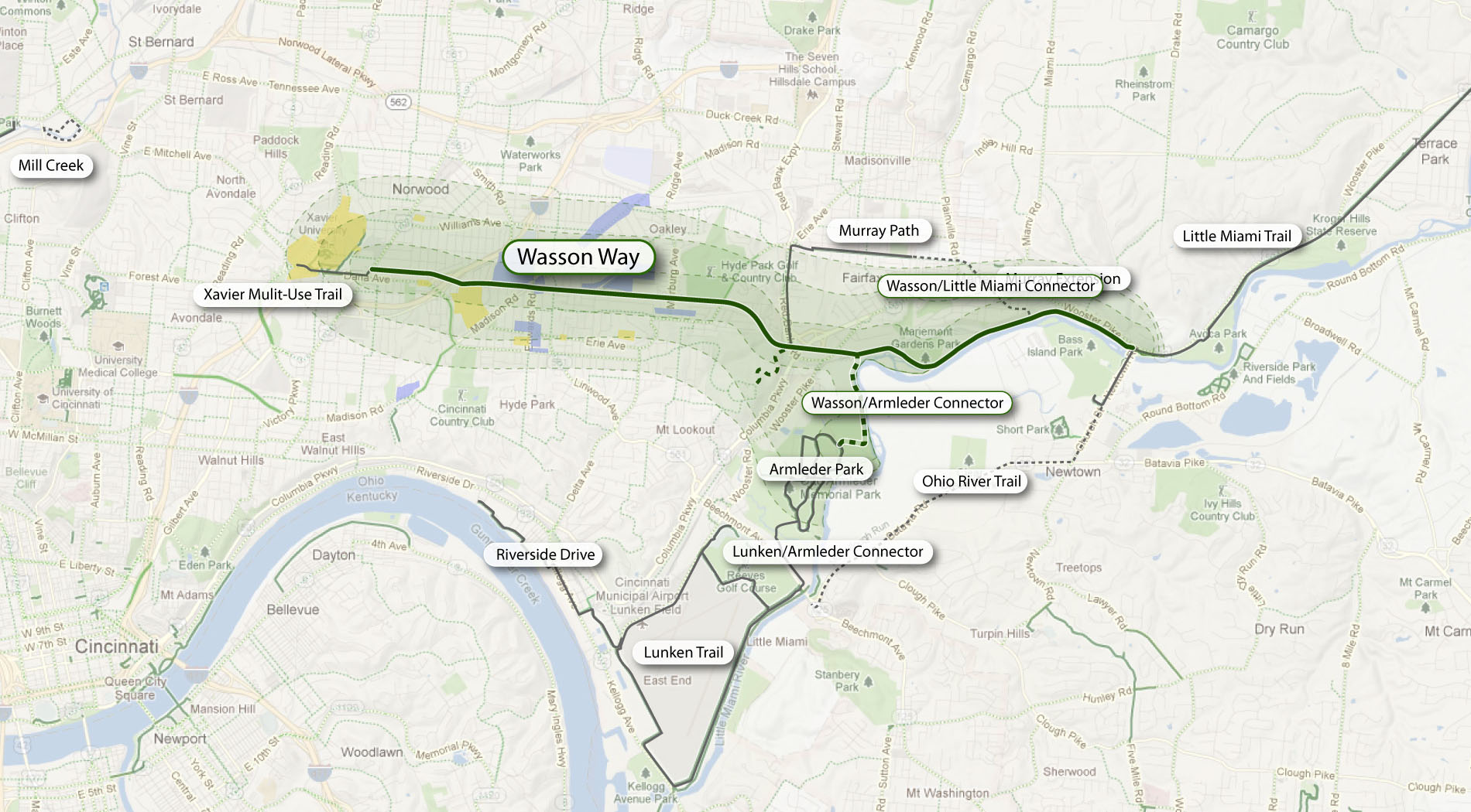

The proposed Wasson Way Trail would use the Norfolk Southern Railroad right-of-way to create a bike trail from the Little Miami Trail to Xavier University. Image provided.

On Wednesday, however, city officials were quick to mention that the upcoming land use study is just that – a determination of how the Norfolk Southern property and its surroundings might be rezoned in order to protect the right-of-way up until and after the right-of-way is purchased by Cincinnati – not a determination of what should be built in its place.

Already, Norfolk Southern has leased some of its railroad property for other uses. In 2011, a shopping center at Wasson Road and Edwards Road created a gravel parking lot on the disused tracks and another business near Paxton Road is looking to do the same.

Although Federal regulations prohibit railroads from subdividing their disused properties until they complete an “abandonment” process, Wasson Way Trail advocates are concerned that revenue from additional leases might discourage Norfolk Southern from selling the right-of-way to the City of Cincinnati at a future date.

Michael Moore, Director of the City of Cincinnati’s DOTE, stated that appraisals of the Norfolk Southern property fall close to $2.5 million. He cautioned, though, that this appraisal should not be thought of as a sale price, as the terms of the City’s purchase of the property cannot be known at this time.

Multi-Modal Use of the Corridor
At the November 14 meeting, city officials also made a point of stating that the title of the upcoming land use study has not been determined but that it will make no explicit mention of bicycle paths, light rail transit, or multi-modal use of the corridor.
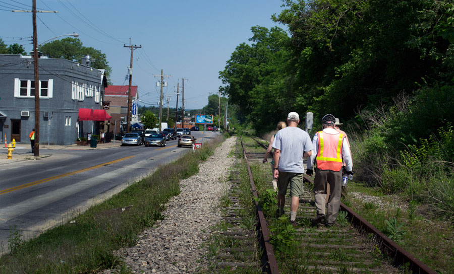

Members of Queen City Bike joined Cincinnati City Councilmember Laure Quinlivan (D) and former MetroMoves chairman John Schneider for a walk along the Wasson Railroad Corridor in May 2012. Photograph by Jake Mecklenborg for UrbanCincy.

Construction of a double track light rail transit line in the right-of-way was first identified by the OKI Regional Council of Governments in the late 1970s. Then in 2002, the Southwest Ohio Regional Transit Authority (SORTA) planned to build a light rail line in place of the Wasson Road freight railroad as part of its MetroMoves plan and failed sales tax referendum. If the ballot issue had passed, construction of a light rail line would have almost certainly commenced soon after Norfolk Southern ceased freight service in 2009.

The width of the Norfolk Southern right-of-way varies wildly as it travels between Xavier University and Hyde Park. It is typically at least 30 feet wide, but in a few places widens close to 100 feet.

In May 2012 members of Queen City Bike walked the right-of-way with John Schneider, who had previously chaired the MetroMoves campaign. At that time, the groups agreed that conflicts between the proposed bike path and light rail line can be avoided if the two are planned as a unified project.

Further complicating the issue is that small sections of the Norfolk Southern property fall under the jurisdiction of the City of Norwood. These sections are all north of the line’s main tracks, for example the railroad’s former yard tracks near Montgomery Road. As Norwood is not involved in Cincinnati’s upcoming land use study, and Cincinnati of course has no influence in its affairs, whatever zoning changes Cincinnati applies will not affect bordering Norwood properties.

The Department of Planning & Buildings will complete its land use study in summer 2013, but with no immediate plans to enter into negotiations with Norfolk Southern, there is no timeline for construction of the Wasson Way Trail.

Categories
Up To Speed

Would an aerial tram make sense for Mt. Adams?

Would an aerial tram make sense for Mt. Adams?.

The number of cities using aerial trams (cable cars) as a means of urban transport is growing. In Cincinnati, the idea of implementing an aerial tram between Over-the-Rhine and Mt. Adams has long been considered. Often times the trams take passengers from low-lying areas to the tops of hillsides, but they are also being used to traverse rivers and more. More from The Guardian:

Cable transport is cost-effective, environmentally friendly, safe and requires little infrastructure. It is particularly suitable for crossing natural obstacles such as rivers or scaling hills, there being no need for expensive engineering work. Over an equivalent distance a cable link costs half as much as a tram line, and though no rival for underground railways in terms of capacity, some models can carry up to 8,000 passengers an hour.

Categories
News Transportation

Zipcar expands Cincinnati offerings to Downtown, Over-the-Rhine

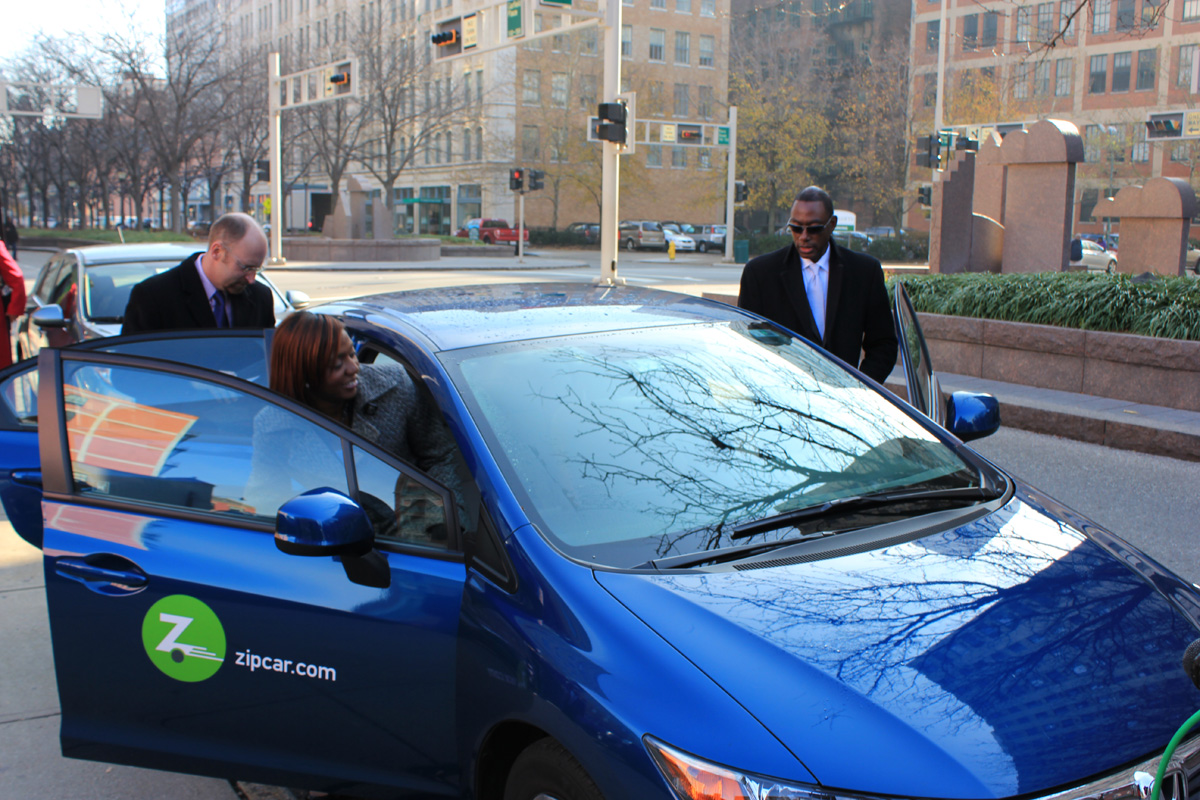
Yesterday, Mayor Mark Mallory (D) announced that Zipcar was expanding its car sharing service in Cincinnati to the Central Business District and Over-the-Rhine.

“Partnering with Zipcar here in Cincinnati is an excellent opportunity to reduce congestion and parking demand, save people money, and provide access for people who would otherwise not be able to go about their day-to-day activities,” Mayor Mark Mallory said.

Until recently, Zipcar had only been available in big cities with more comprehensive mass transportation options; however Zipcar began testing its service with University of Cincinnati students and faculty last year. The initial service has blossomed into the full service being announced today.  Three “pods” of two cars each will be located in both neighborhoods as well as the two University of Cincinnati locations.

Driving a Zipcar requires a membership which can be obtained through their website. From there, members reserve a car for a certain amount of time and use it during the day. Members then use a key card or their smartphones to gain access to the designated car. Rates on Zipcar vehicles in Cincinnati start as low as $8.50 per hour and $69 per day. Gas, reserved parking spots, insurance, roadside assistance and up to 180 miles per day are included in the hourly and daily Zipcar rates on all Zipcar vehicles. Cars can be reserved for time periods as short as an hour or for up to several days.

Users of smartphones such as iPhones and Android devices, may download the Zipcar mobile application to make reservations, lock and unlock the vehicles as well as honk the horn to help locate the vehicle. Members can also use Zipcar’s “Reserve a Zipcar” app on Facebook to view available Zipcars and make, extend or cancel a reservation all from their Facebook account. Reservations can also be made over the phone or by using the Zipcar website.

The introduction of Zipcar could bring car sharing closer to reality city employees as well. As previously reported by UrbanCincy, the City of Cincinnati has been investigating ways  to reduce its city-owned fleet and instead use car-sharing services such as  Zipcar for certain city departments. This idea may gain some traction as City Council moves into budget season and begins to look for ways to close this year’s budget gap.

It had also been recently mentioned as a policy point by City Councilmember P.G. Sittenfield (D) in a recent e-mail. In it he states, “our fleet must more precisely match the need, and we should ensure that we are optimizing car-sharing and minimizing fleet that sits idle.”

City officials have disclosed to UrbanCincy that utilizing the car sharing service will allow the city to reduce the number of pool cars the city owns.

Categories
Up To Speed

What would a trillion fewer driving miles mean?

What would a trillion fewer driving miles mean?.

Despite a stronger economy and more people living in the United States, Americans drove a billion fewer miles in July 2012 than a decade early. The trend of fewer people driving, and existing drivers driving less started in 2004 and has yet to let up. Should trends continue, Americans may be driving a trillion fewer miles annually by 2025. More from Streetsblog:

There are good reasons to believe the current slowdown in driving may persist. A report by the U.S. Public Interest Research Group in April showed that youth are leading the trend toward less driving. While the National Household Travel Survey only allows comparison of driving in 2001 and 2009, it shows that Americans aged 16 to 34 reduced their driving miles by 23 percent between those years. Meanwhile, youth are increasing their use of public transit, biking and walking faster than the general population. Changing patterns in the use of information technology and changing preferences for urban living may be major factors in these shifts.

Categories
Arts & Entertainment Development Transportation

Rob Woodward showcases Cincinnati’s center city in new time-lapse video

Cincinnati-based photographer Rob Woodward has put together a collection of his time-lapse photography for a new video showcasing various scenes throughout the center city.

Woodward is a graduate of Cincinnati State Technical & Community College’s audio/video production program. Since then he has done video production work for the Cincinnati Reds, worked as an assistant camera operator for the failed Queen City reality show, and currently works full-time as a photographer for Fox 19, WXIX.

The video showcases scenes of Cincinnati’s skyline from Devou Park, views from the Carew Tower Observation Deck, Lytle Park, Mirror Lake in Eden Park, a bustling Findlay Market, the newly renovated Washington Park, Sawyer Point, Great American Ball Park, The Banks, Smale Riverfront Park, and various shots from the Ohio River.

Woodward says he hopes to expand upon this collection over the next year, but for now you can enjoy the nearly two-and-a-half minute video featuring music from Explosions in the Sky.