Categories
Development News Transportation

Cincinnati becomes first Ohio city to install green bike lanes

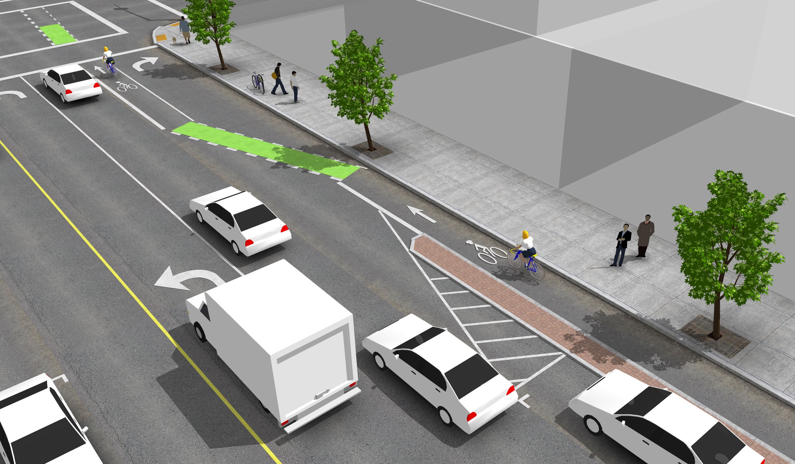
Construction workers installed bright green bike lanes at three conflict points along Ludlow Avenue yesterday. The new green bike lanes are a first for Cincinnati as it continues to work towards making city streets safer for area bicyclists.

According to the National Association of City Transportation Officials (NACTO), experimentations with specially colored bike lanes first took place in the mid-1990s. Then, between 1997 and 1999, the City of Portland worked with the Federal Highway Administration (FHWA) to mark 10 conflict areas with blue coloring and accompanying signage. Since that time, the FHWA has determined that green is a more appropriate color for bike lanes on public streets, so as not to be confused with accessibility parking.


The City of Cincinnati used NACTO’s standard design for a truncated bike lane through an intersection as the basis for its green bike lanes on Ludlow Avenue. The installation makes Cincinnati the first Ohio city with green bike lanes.

Green bike lanes have begun to appear in cities throughout North America in recent years to not only mark areas of conflict, but also delineate entire bike corridors. In the Midwest, Chicago has led the charge using green bike lanes for entire cycle track corridors, bike boxes at traffic signals, and at special conflict points.

According to city officials, Cincinnati’s first application of green bike lanes will mark Ludlow Avenue where it intersects with Old Ludlow Avenue, Central Parkway and a driveway entrance to Cincinnati State (map). City planners also say that there will be additional green bike lanes to come.

“We are considering using green markings where the Gilbert Avenue bike lane will intersect with the right-turn lane into the casino,” explained Department of Transportation & Engineering (DOTE) planner, Melissa McVay.

McVay went on to say that City is using NACTO’s design guidelines and specifications for these projects, and that going forward, green bike lanes will be considered at all high conflict areas where motorists must cross a bicycle path.

The idea behind the green markings is to improve the visibility of bicyclists, and in the process, improving safety.

“In this [Ludlow Avenue] case the green lanes help negotiate cars desiring a right hand turn through a bike lane that continues straight ahead,” said Frank Henson, President, Queen City Bike. “By giving the bicycle lanes a different color, motorists realize that, in making their turn, they are crossing into another travel lane reserved for cyclists, and that they must yield to bicycle traffic in order to complete the turn.”

The City of Cincinnati Bicycle Transportation Program has installed 35.8 miles of bicycle facilities to-date, with an additional 289.9 miles planned in a citywide bicycle network.

And when asked about what could be done to continue to improve safety for Cincinnati-area bicyclists, Henson concluded that, “The best thing the City of Cincinnati can do to improve safety for street cycling is to continue to carry out the Cincinnati Bike Plan, improving the network of bike routes, lanes, trails, and paths in the area. Better education and enforcement of traffic law for both cyclists and motor vehicle operators is also necessary.”

We sat down with Melissa McVay on Episode 8 of The UrbanCincy Podcast to discuss Cincinnati’s bike culture – where we stand, how we got here, and what needs to take place next. You can stream that podcast online for free, or subscribe to The UrbanCincy Podcast on iTunes so that you don’t miss an episode.
Categories
Business Development Transportation

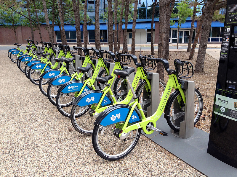
Cincinnati City Leaders to Move Forward with Ohio’s First Bike Sharing System

A new study, prepared by Alta Planning + Design, has determined how and where a bicycle sharing system could be implemented in Cincinnati in a way that will compliment its expanding Bicycle Transportation Program.

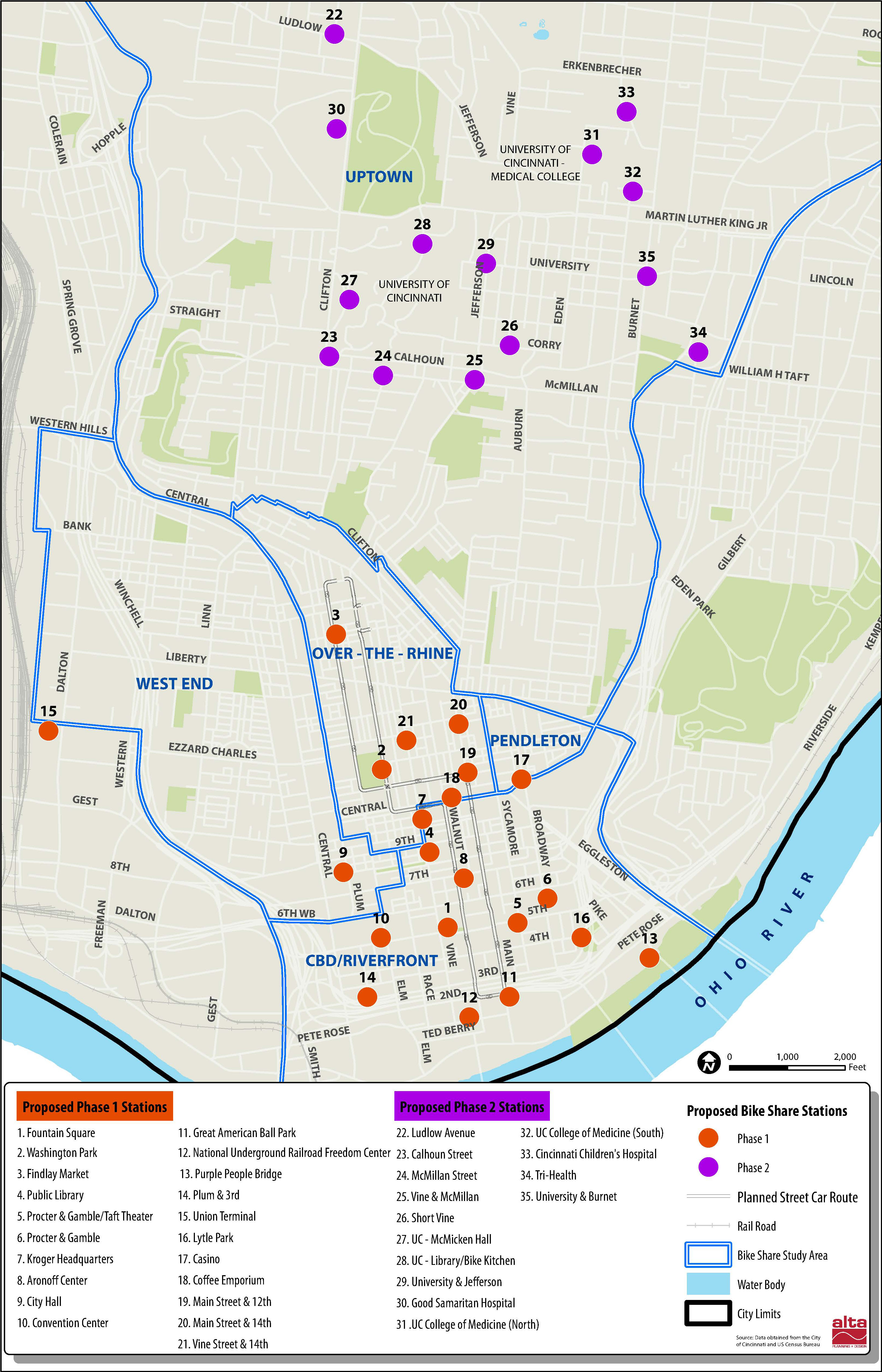
The recently released report was called for by city leaders in May 2012, and identifies a 35-station, 350-bike system that would be built over two phases in Downtown, Over-the-Rhine, Pendleton, Clifton Heights, Corryville, Clifton, Avondale and the West End.

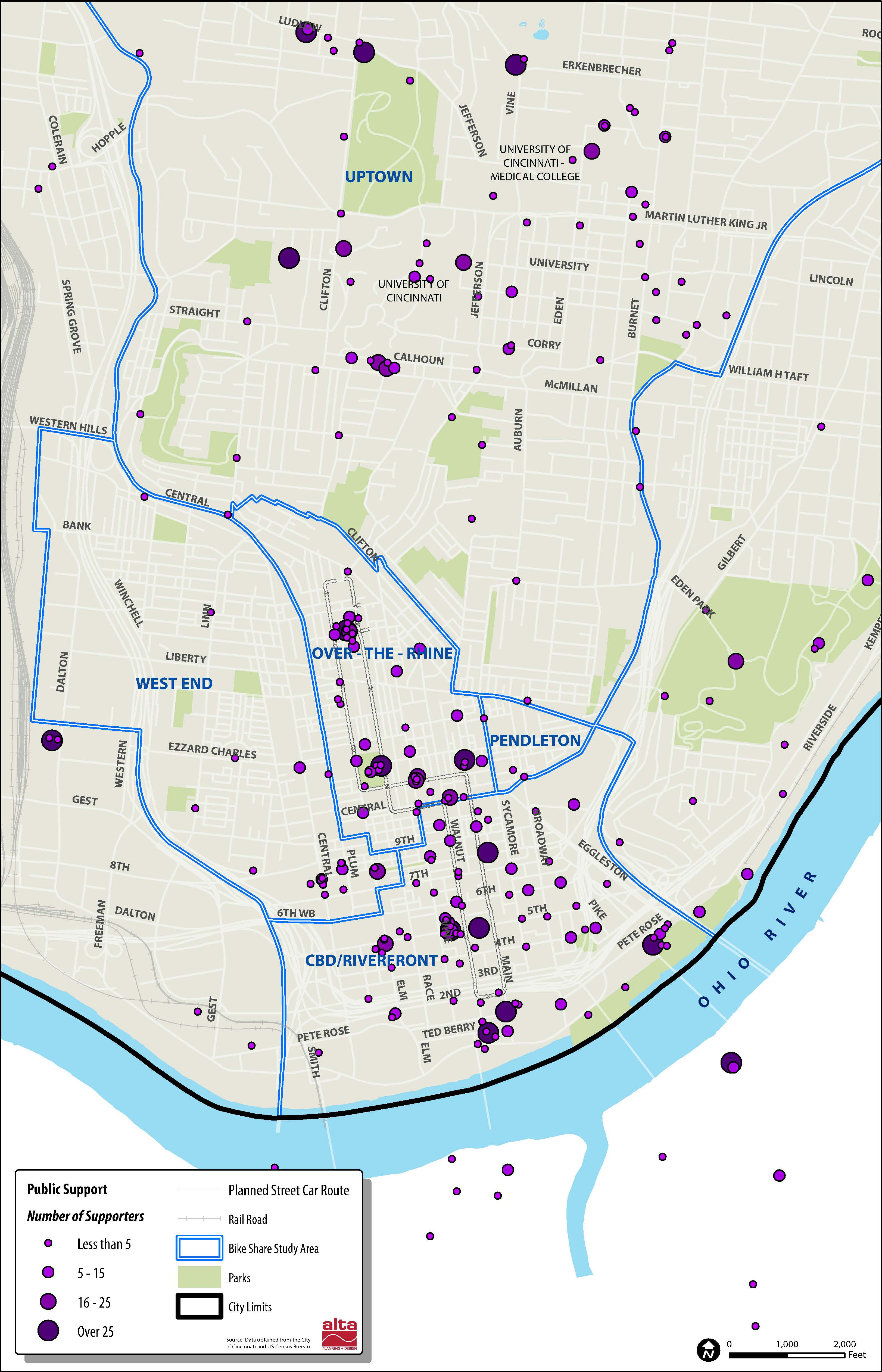
“We went into this study wanting the public to be a big part of the process. They contributed more than 300 suggestions for stations and cast nearly 2,000 votes,” said Michael Moore, Director of the Department of Transportation & Engineering (DOTE). “Thanks to all their input, this study helps ensure bike share is relevant and useful to the residents and commuters in the downtown neighborhoods.”


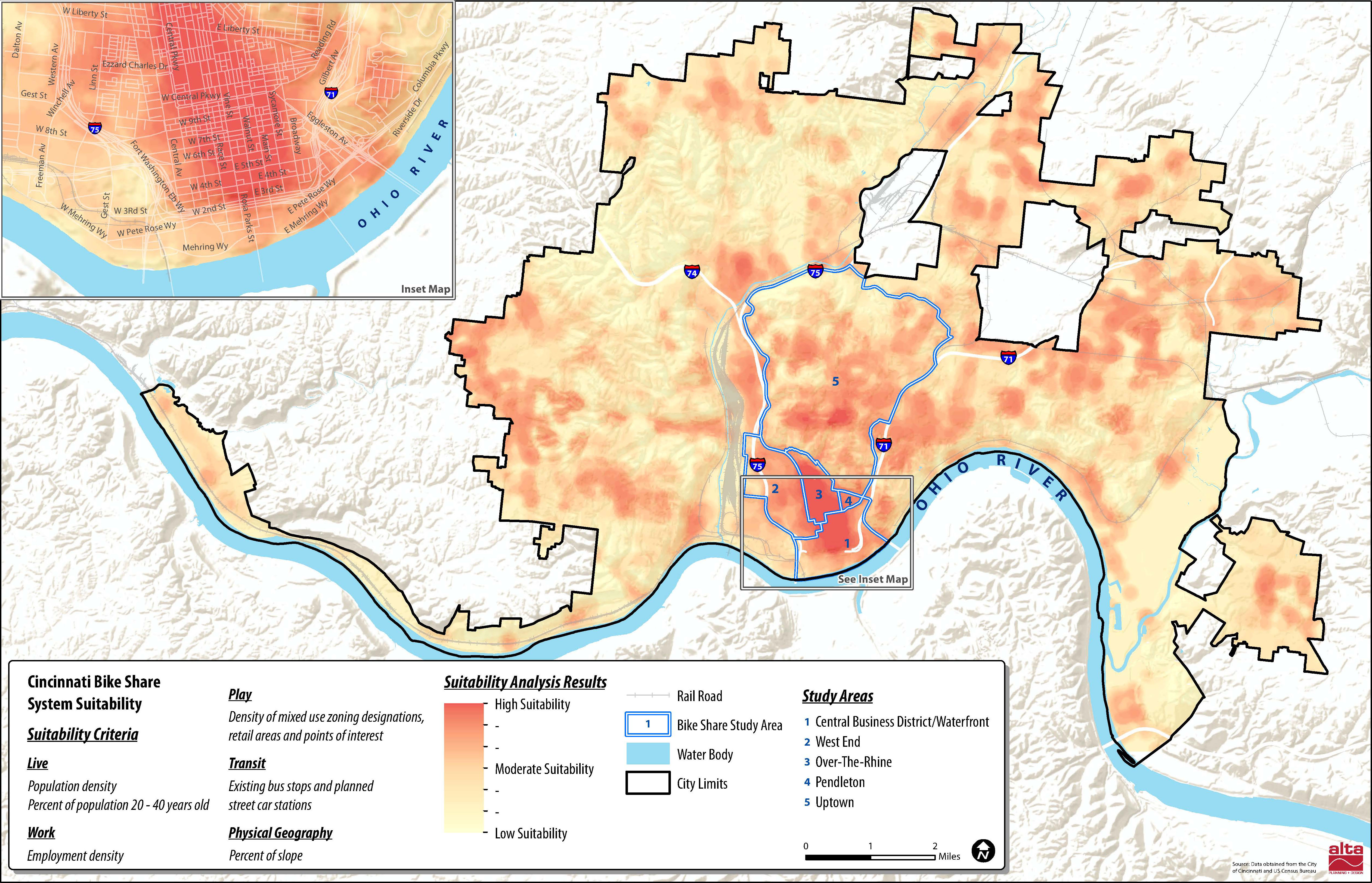
Several neighborhoods throughout the city were determined as potential areas to be included in a future Cincinnati bike share system. Map provided by Alta Planning + Design.

City officials also say that locations throughout northern Kentucky’s river cities were also popular, and would make for a logical expansion in the future should system arrangements be achieved.

According to the report, the 35 station locations were identified through public input and through a variety of suitability factors that include population density, percentage of residents between the ages of 20 and 40, employment density, mixture of uses and entertainment destinations, connectivity with existing and planned transit networks, and the terrain in the immediate area.

“In general, there are enough positive indicators to suggest that bike sharing is feasible in Cincinnati,” Alta Planning + Design wrote in the 49-page report. “There are no fatal flaws, although a smaller dependency on visitors and ordinances restricting advertising would need to be overcome to make the system financially viable.”

The financial viability of the project is particularly important in Cincinnati’s case as city officials have determined that a privately owned and operated system would be the best business model for Cincinnati.

Alta Planning + Design estimates that the potential 35-station system, spread throughout Downtown and Uptown, would cost approximately $2 million to construct and nearly $200,000 to operate annually. While user fees are expected to sustain a portion of the annual operating costs, system operators will most likely need a variance to city law to allow for advertising on the stations, as is commonplace for bike sharing systems throughout the world.

     
More than 2,000 responses helped determine public support for potential station locations [LEFT]. The initial system would be built out over two phases in Downtown and Uptown [RIGHT]. Maps provided by Alta Planning + Design.

“As of now we do not intend to invest any public funds in the system, other than in-kind assistance with marketing and station siting,” explained DOTE Senior City Planner Melissa McVay, who recently sat down to discuss Cincinnati’s bike culture on Episode #8 of The UrbanCincy Podcast.

Annual membership fees and hourly rates would be determined by the eventual company selected to operate the system, and would be contingent upon how much money could be raised through advertising and local sponsorships.

In addition to drilling into local details and demographics pertinent to a potential Cincinnati bike sharing system, the feasibility study also compared Cincinnati to other cities throughout North America that have operational bike sharing systems.

Through that analysis it was found that Cincinnati’s system would be smaller than those in Miami, Boston, Washington D.C., Montreal and Toronto, but that it would be larger than systems in San Antonio, Des Moines and Chattanooga. Cincinnati’s system is also anticipated to have a more favorable trip comparison, for the first year of operation, than both Minneapolis and Denver.

The report also estimates that Cincinnati’s system would attract 105,000 trips in its first year of operations, with that growing to 305,000 in year five once both Downtown and Uptown regions are operating, with approximately 25 percent of trips replacing a vehicle trip.

“We want Cincinnatians to be able to incorporate cycling into their daily routine, and a bike share program will help with that,” Moore explained. “Bike share helps introduce citizens to active transportation, it reduces the number of short auto trips in the urban core, and it promotes sustainable transportation options.”

The City of Cincinnati is expected to issue a request for proposals, within the next month, that will call for bids from an operator of the planned system. If all goes according to plan the Midwest’s sixth, and Ohio’s first, bike share system could become functional as early as the operator’s ability to acquire funding.

Categories
Up To Speed

What issues facing cities are you hoping to hear discussed at tonight’s presidential debate?

What issues facing cities are you hoping to hear discussed at tonight’s presidential debate?.

The second of three planned presidential debates for the 2012 Election is scheduled for this evening. This debate will have a “town hall” format and will take place from 9pm to 10:30pm. One item that was not mentioned once by either Governor Romney (R) or President Obama (D) in the first debate was cities. Cities are where abstract issues debated at the national level, meet reality. Things like health care, education, gun control, infrastructure, immigration, budgets, and voting rights all must be faced at the local level, with no one else to pass the issue along to.

So with that said, which issue facing cities would you like to hear the presidential candidates address this evening in New York? More from Forbes:

Here’s hoping tonight’s debate format will shake things up a bit. The “town hall” style brings in actual real people who offer us the best chance yet of introducing some new topics into the conversation. And there are a lot of them. Immigration, the drug war, privacy, drone strikes, sanctioned assignation, to name just a few. To get a jump start, we reached out to Forbes’ million-plus followers and asked them what they want the candidates to debate tonight. We’ve already got some great responses at #Prezquestions – delivered with the kind of no-BS bluntness we hope those lucky enough to get to ask questions tonight deliver, too.

Categories
Development News Transportation

Cincinnati officials are looking for design ideas as they work to cap urban highway

Billions of dollars of public and private investment has transformed Cincinnati’s central riverfront over the past decade. What was once a flood-prone industrial center turned unusable waterfront property, is now home to a new park, neighborhood, museums, and professional sports venues.

The investments made to date have been so successful, in fact, that they are creating spinoff investment in the Central Business District. A remaining hurdle, however, is the crossing of Third Street, Fort Washington Way (FWW), and Second Street.

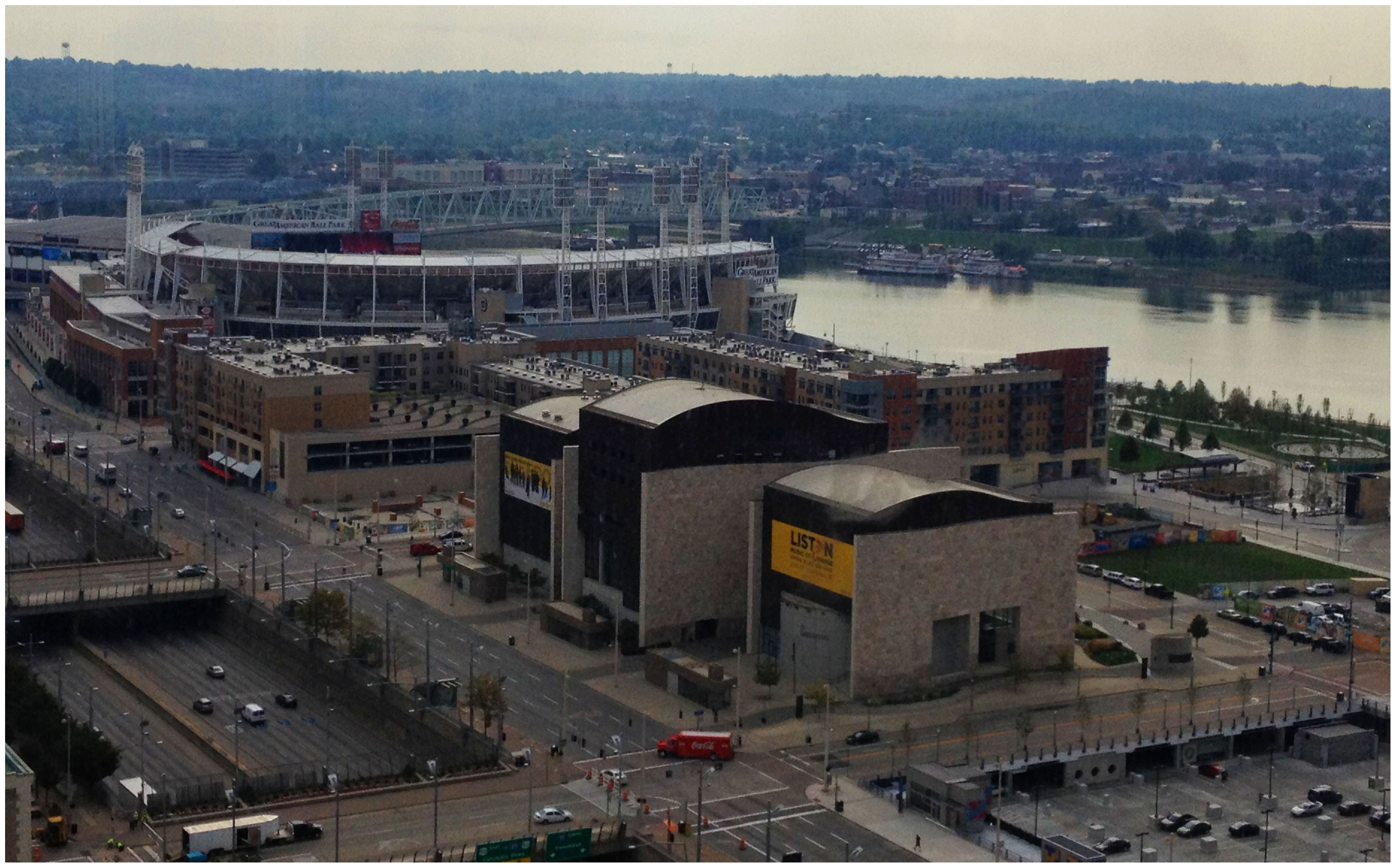
The nearly 300-foot span of roadways was significantly reduced in width when Fort Washington Way was reconstructed in 2001, but the span remains a visual barrier for many of those in the Central Business District or at The Banks.

Cincinnati officials are looking to build off of recent success by capping Fort Washington Way. Photograph by Randy A. Simes for UrbanCincy.

The problem was expected by city officials, in the 1990s, during original planning efforts for the central riverfront’s transformation. As a result, city leaders worked to raise $10 million to construct pile foundations that could one day support a cap over the interstate highway running beneath street level on FWW.

The pile foundations are capable of extending 600 feet over the highway roughly between Elm Street and Main Street. According to engineers who worked on FWW’s reconstruction, the caps could support the weight required for a park, or built structures depending on height and building materials.

No specific development plan for the caps has been developed however, and now the city is launching a design competition called Connect the Blocks to establish a vision for space.

“The Banks is well underway, downtown is growing, and now we must begin thinking about what we as a community want to see over Fort Washington Way to connect downtown and the riverfront,” City Manager Milton Dohoney stated in a prepared release. “We must first have a common vision of what we want, then we can establish the roadmap to get there.”

The national competition is calling on architectural, engineering and design professionals to create and submit concepts and cost estimates for the caps that are to be built over FWW. According to city officials, three to five finalists will be selected and awarded stipends to further refine their designs.

St. Louis has dealt with similar issues as it has tried to bridge the divide created by I-70 between downtown and the Gateway Arch grounds. While I-70 will not be capped entirely, a one block portion is envisioned to connect Jefferson National Expansion Memorial with Kiener Plaza in the CityArchRiver 2015 plan.

In Ohio, the only similar example of such a project exists in Columbus where a $7.8 million cap was constructed over I-670 along N. High Street. It includes approximately 25,000 square feet of street-level retail and connects Columbus’ downtown with its Short North district.

The City of Cincinnati held the first of two public meetings, on the design competition, last Wednesday in Madisonville. The second meeting is scheduled to take place on Tuesday, October 9 at 6pm at the Main Public Library (map). The public is also invited to weigh in on the process by participating in an online survey going on now, and officials also say that the public will be invited back to view the finalists’ designs once they are selected.

Full details about how to participate in the eight-month design competition can be found on the project’s website. The implementation of any winning design, officials say, will be dependent upon the availability of funding.

Categories
Arts & Entertainment News Transportation

2012 MidPoint Music Festival bicycle parking overview

The City of Cincinnati has partnered with the MidPoint Music Festival (MPMF), for the second consecutive year, to offer expanded bicycle parking options.

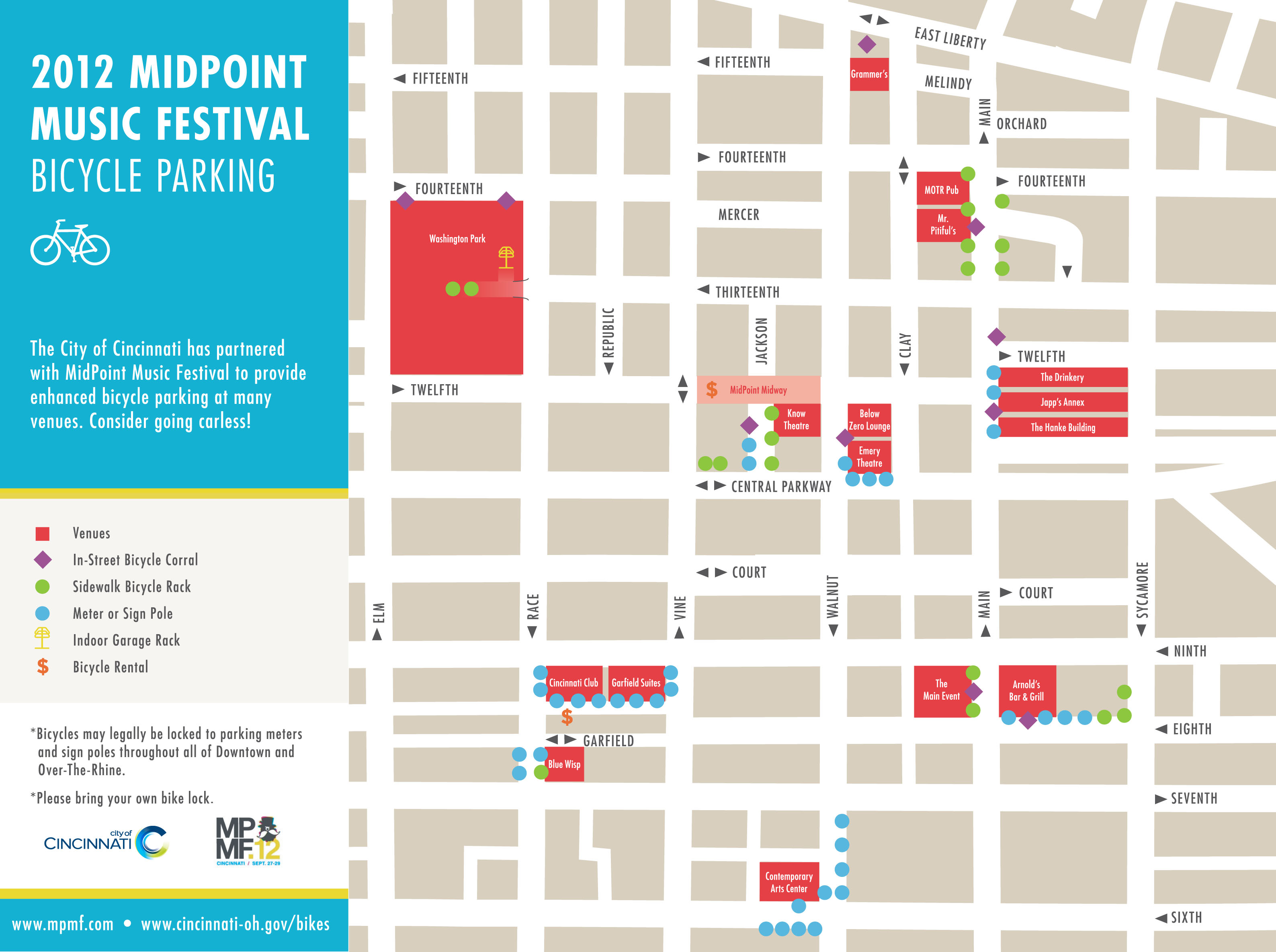
This year’s MPMF is shaping up to be the biggest yet, and as a result, city officials say that they will convert nine on-street automobile parking spaces into bicycle-only parking stalls. Each stall will include a lockable bike corral that can accommodate up to 12 bicycles comfortably.

The spaces will be temporary in nature, and will be removed at the end of the three-day music festival which begins today.

“We want to encourage festival goers to try going carless this year,” explained Cincinnati’s Department of Transportation & Engineering (DOTE) director, Michael Moore. “With all of the venues located in such a compact area in OTR and Downtown, this is a great opportunity to experience how easy it is to get around town on a bicycle.”

The converted spaces will compliment an existing permanent collection of structured bicycle parking throughout the Central Business District and historic Over-the-Rhine. Those hoping to take advantage of the bicycle parking options during this year’s MPMF can refer to the following map for guidance.