Categories
Development News Politics Transportation

The surprising story of sustainability in Seoul

When thinking of the mega-cities in Asia, one does not often first think of sustainability or environmental stewardship. But the reality, as I experienced in Seoul, is much different from the perception.

As the 24.5 million-person mega-city continues to grow both up and out, Korean leaders have turned a watchful eye to environmental sustainability. Projects like the removal of an elevated highway to restore a stream through the heart of the city, riverfront park development, investments in transit, and a massive transition to electric-powered buses are powering the world’s third largest city towards a sustainable future that was once considered inconceivable.

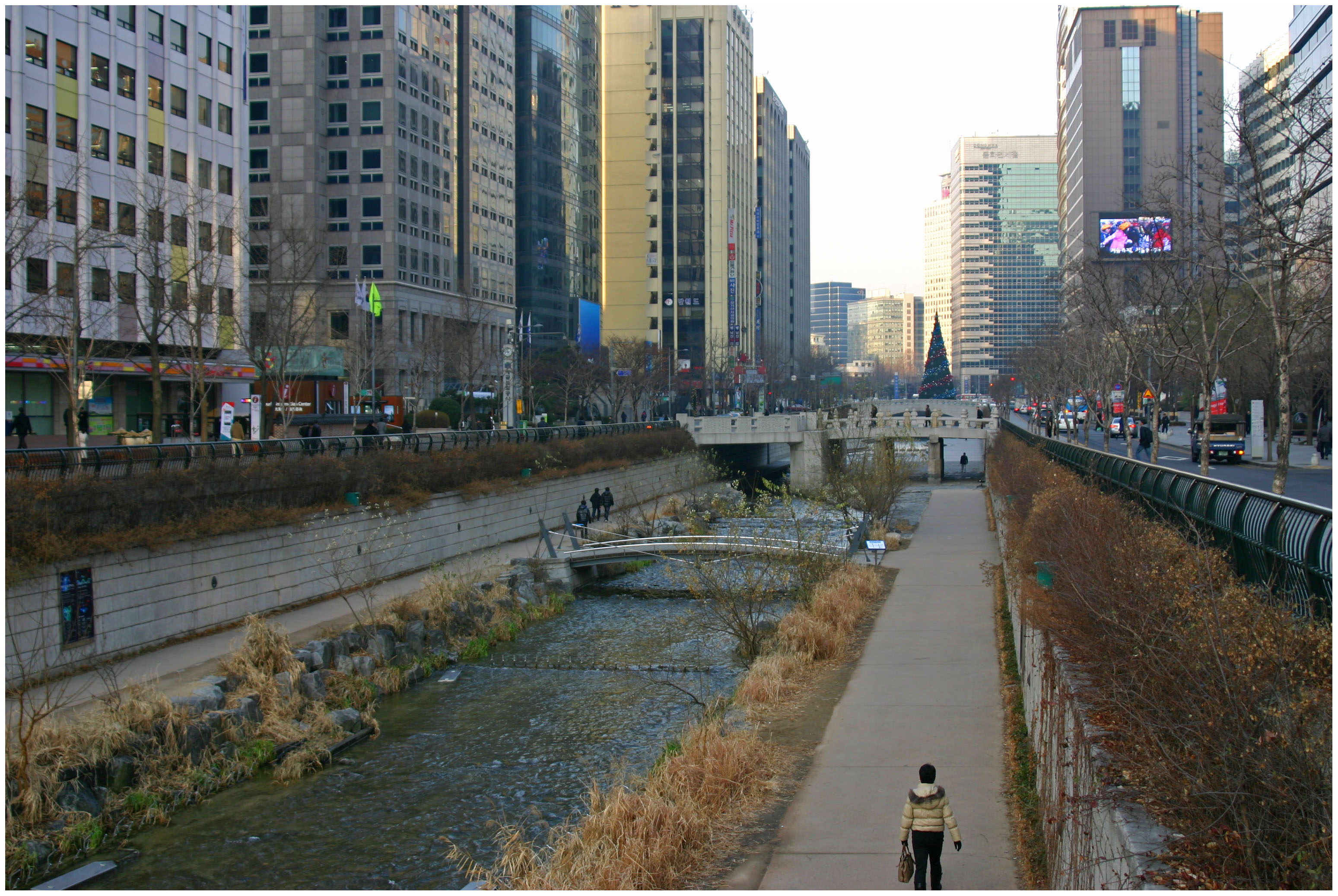
Cheonggyecheon Stream Restoration:
In the heart of Seoul’s Jongno-gu is a sub-level stream. The Cheonggyecheon Stream stretches six kilometers and follows the path of what was previously an offensive elevated highway. The highway was removed and replaced by the stream and two narrow parallel roadways.

While the $900 million project received much criticism and pushback when it began in 2003, the result has been one of the most successful projects of Lee Myung-Bak’s administration. Since the stream opened in 2005, Koreans, and visitors alike, flock to the stream for casual strolls, use it as a place to jog or relax, and the stream has become the epicenter for major cultural events like the annual Seoul Lantern Festival.

Environmentally speaking, the restoration of the Cheonggyecheon Stream has helped to increase wildlife in the area, cool down the urban heat island effect in the immediate vicinity by an average of 38.5 degrees, decrease automobile traffic, and increase transit ridership.

What the stream does so successfully is provide a corridor of open space in an otherwise extremely busy and crowded city center. It serves as both a welcoming getaway as much as a symbol for the future of a more eco-friendly Seoul.

Banpo Hangang Park:
If you head south from the Cheonggyecheon you will pass by Namsan Tower and park, U.S. Army Garrison Yongsan, the famed Itaewon neighborhood along with several other neighborhoods. At that point you will reach the Han River. There the southern bank of the river has, in recent years, been transformed into a world-class park in an effort to restore the river’s edge while also creating a dynamic new park space for those living in the otherwise congested Seoul.

The project began in 2007 and saw its first elements come online in April 2009. Inside the linear park visitors are able to find playgrounds, an inline skating track, soccer field, basketball courts, bike lanes and a rental shop, picnic locations and other recreational opportunities.

The park is part of the larger Hangang Renaissance Project, but represents a movement taking place around the world to transform flood-prone areas into functional park spaces. In Seoul, the addition of open space is of even greater importance than many other cities, but the Banpo Hangang Park is similar to the string of riverfront parks in Cincinnati including the new Central Riverfront Park, Sawyer Point, Bicentennial Commons, and the International Friendship Park.

Transit & Electric Buses:
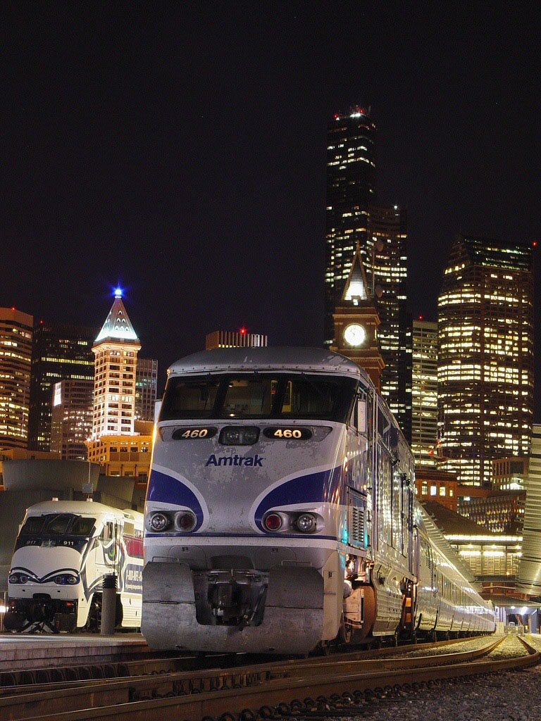
In addition to having the world’s third largest subway system and a truly robust bus network, Seoul officials have announced that they intend to convert the city’s massive bus fleet to electric. In fact, transportation officials have announced that half (120,000 buses) of its entire fleet will be electric by 2020 – by far the most aggressive goal anywhere in the world.

The conversion of Seoul’s buses to electric is matched by their willingness to invest in their system. The city boasts a large bus rapid transit system that was smartly copied from Germany, fast and timely service, commuter and circulator lines, and a pay card system that integrates with taxis and trains all throughout the Republic of Korea.

Combine these projects with the wave of green building developments and other cultural movements towards sustainability and you have yourself a surprising mega-city in east Asia that has shifted its attention from simply growing as fast as possible, to growing the best way possible.

Categories
Development News Politics Transportation

$809M identified for extension of I-74 through Hamilton County

The Ohio Department of Transportation (ODOT) published its 2011-2015 Major New Construction Program List on December 9. The list included six funding allocations totaling more than $809 million of expressway work that will set the stage for the long-envisioned extension of I-74 through Cincinnati.

The money is being allocated through the veil of the controversial Eastern Corridor Project. $115 million has been budgeted for reconstruction of the US 32 – I-275 cloverleaf, grade separation of US 32 near this interchange, and modifications to Red Bank Road that anticipate its reconstruction as a fully grade separated expressway. Another $13.8 million has also been budgeted for the long-planned $366 million US 32 bypass and Little Miami River bridge between Red Bank Road and Interstate 275.

This partial funding of all segments of the Eastern Corridor Project on ODOT’s current Program List illustrates that the project is still very much on the table, and that ODOT will likely turn its full attention and funding toward the project after the reconstruction and widening of Interstate 75 is completed later this decade.

I-74 Extension Details
Many have suspected the use of the Eastern Corridor Project was being used as a veil for an interstate project, but until now there has been no financial backing to these claims. The extension of I-74, through Hamilton County, would be realized by upgrading US 32 between I-71 and I-275, and by upgrading other stretches of local expressways to interstate status and giving them the I-74 name. Once the extension is complete, I-74 would run from its current terminus at I-75 in Cincinnati to existing sections of I-74 in North Carolina.

In such a scenario, three miles of I-75 between Northside and Bond Hill would be co-signed as I-74, the entirety of the Norwood Lateral would become I-74, and I-71 between the Lateral and Red Bank Road would be co-signed as I-74. From that point, the planned “Eastern Corridor” US 32 bypass, which is being built to interstate highway design standards, can with the stroke of a pen become I-74.

Critical pieces of such a cross-county plan will soon commence construction as part of the I-75 Millcreek Expressway project. This year, the Millcreek Expressway project will fund $9 million in modifications to the I-74 Colerain Avenue interchange near Mt. Airy Forest. The nearby I-74/75 interchange in Northside, the present site of I-74’s terminus, is scheduled to be completely reconstructed in 2013. The I-75/Norwood Lateral interchange is scheduled to be rebuilt between 2016 and 2018.

Beneficiaries of an I-74 Extension
US 32 between I-275 and eastern Ohio, completed in the late 1990’s, was built to near-interstate specifications in anticipation of its future designation as I-74. In the fifteen years since its completion, it has attracted almost zero development along its more than 200-mile path. It is unlikely that replacement of its at-grade intersections with diamond interchanges will encourage increased private investment.

In the Cincinnati area, the most obvious beneficiaries of the Eastern Corridor plan, aside from those construction companies who would actually build it, are those who control tracts of land in Clermont County, who no doubt wish to develop large-scale sprawl along US 32 outside the I-275 loop. Such a roadway would only marginally improve the area’s access to downtown Cincinnati, and therefore strengthen the position of Kenwood, Blue Ash, and other suburban areas that compete with it for jobs and commerce.

The possible designation of the Norwood Lateral as an interstate would make its reconstruction a priority, and reconfiguration of its ramps could make possible the redevelopment of vacant land in Norwood and Bond Hill. Reconstruction of the I-71/Norwood Lateral interchange could accelerate the redevelopment of the Cincinnati Milacron site.

Potential Impacts
The US 32 bypass will negatively affect property values and the quality-of-life presently enjoyed by those who reside in the Newtown area. Additionally, the Sierra Club has campaigned against the highway’s Little Miami River bridge since the concept was introduced, arguing that its construction will negatively affect the river’s wildlife.

From the 1930’s on through the 1960’s, every mile of the 43,000-mile Interstate Highway System first appeared as a line on somebody’s map. In Cincinnati, remnants of abandoned subway right-of-way gradually became parts of what we know today as I-75, I-71, and the Norwood Lateral. The idea was to spread the population of Cincinnati into suburban areas. Another cross-town freeway in the form of I-74 will further depopulate the core of our region.

Categories
Development News Politics Transportation

3C Rail not dead yet according to All Aboard Ohio leaders

Throughout his campaign for governor, Governor-Elect John Kasich (R) repeatedly stated that he had no intention of ever moving forward with the 3C Rail project, a train that would have connected Cleveland, Columbus, Cincinnati, and Dayton. So with Secretary LaHood’s announcement on Thursday that the $400 million for the 3C rail project was being taken away, he made Kasich’s campaign promise of “the train is dead” a reality, right?

Well, All Aboard Ohio, an advocacy group for inter-city travel in Ohio, is saying otherwise. In fact, in a press release they stated that the Dept. of Transportation is moving prematurely in redirecting the funds.

“Until grant agreements with the new state recipients have been signed, we don’t consider this a done deal,” said All Aboard Ohio President Bill Hutchison, noting that it often takes months to finalize such agreements.

With just under a month left in the term of Governor Ted Strickland (D), the nonprofit believes there is still time to act.

“We are calling for an open, honest dialogue between Governor Strickland, Governor-Elect Kasich and potential 3C partners to consider an alternative that could be instituted within the same time frame ODOT was expected to move forward with 3C,” said Hutchison.

Ironically, Thursday’s announcement came only hours after a plan to pursue the 3C project without state involvement was released. Created by All Aboard Ohio and others, the plan calls for the creation of a Joint Powers Authority (JPA). If created, the JPA would consist of local governments and transit authorities which could then grant a franchise to a private group who would operate the rail service. The group would finance the project through, among other things, revenue generated by station leases, food service, and advertising.

“With looming threats of unprecedented global oil shortages by 2015, the Baby Boom generation starting to turn 65 years old in 2011 and young Ohioans leaving for states that don’t force them to drive everywhere, now is not the time for Ohio leaders to let this money slip away,” Hutchison concluded.

Categories
Development News Politics Transportation

Cincinnati secures full funding for first phase of modern streetcar system

The Transportation Review Advisory Council (TRAC) of the Ohio Department of Transportation (ODOT) announced yesterday that they have unanimously recommended an award of $35 million for the construction of phase one of the Cincinnati Streetcar. The $35 million award means that the first phase of Cincinnati’s modern streetcar system is now fully funded.

To date, the Cincinnati Streetcar has secured $150 million through a variety of public and private resources to fund the first phase of the system which is estimated to cost $128 million.

“Today was a great day for our streetcar project,” exclaimed Cincinnati Mayor Mark Mallory in an email yesterday. “We now have the full amount needed to complete the first phase. This will help grow our city and improve our financial future.”

In addition to $35 million for construction, TRAC also recommended $1.8 million for planning and preliminary engineering work for phase two of the project which will extend further throughout Cincinnati’s uptown neighborhoods.

The Cincinnati Streetcar project scored 84 out of a possible 100 points in TRAC’s ranking – by far the highest total of all transportation projects from around the state. As a result of that robust score, ODOT officials approved TRAC’s $15 million recommendation for the Cincinnati Streetcar project in May 2010.

During recent budget debates, some advocacy groups have lobbied against the Cincinnati Streetcar project and said that the money should be instead used for other purposes – mainly preserving police and fire sources.  City officials have responded by repeatedly stating that the capital funds identified for the Cincinnati Streetcar are restricted funds that can only be used on capital projects – not operating expenses like personnel. Furthermore, city officials also believe the streetcar investment will return an estimated $3 for every $1 invested.

“In light of the budget problems facing the city, I am convinced that we must use every economic development tool we can to bring residents, jobs, businesses – and tax revenue – to the city,” explained City Manager Milton Dohoney. “Together, the streetcar, casino, The Banks, 21c Hotel, and other investments generate bigger returns that will stabilize and grow our local economy.”

Once complete, the system will be managed and operated by the Southwest Ohio Regional Transit Authority which currently manages and operates Metro bus service. Phase one of the Cincinnati Streetcar is expected to take on its first passengers in spring 2013.

Categories
Development News Transportation

Cincinnati to examine bus rapid transit as part of expanding transit network

As Cincinnati moves forward with the development of the Midwest’s first modern streetcar system, a political leader is pushing for even greater transit improvements that would compliment an increasingly diverse collection of alternative forms of transport.

Cincinnati Vice Mayor Roxanne Qualls is proposing a robust network of bus rapid transit (BRT) that would connect the region’s commuters with major employment centers like Uptown and Downtown. Qualls believes BRT is a cost-effective and innovative transit strategy.

“Bus rapid transit incorporates many of the advantages of light rail, but is cheaper and can be implemented quickly,” Qualls said in a prepared statement. “Cities around the world and the country are giving commuters a great transit option now with rapid transit.”

Many cities around the United States and internationally are beginning to look at BRT more closely as a cheaper alternative to building dedicated rail transit systems. After first being popularized in Bogotá, Columbia, bus rapid transit now exists in 33 cities throughout the world with an additional 22 systems planned.

What differentiates BRT routes from other bus routes is the dedicated lanes they use. These dedicated corridors are often complimented by signal prioritization and timing that allows for faster travel times over long distances.

“Cities are looking to rapid transit to meet increased commuter demand and to spur development,” Qualls stated. “Because the conversion to rapid transit is faster and cheaper than developing light rail, it is an important interim step that helps build transit ridership and provides a great service in the near term.”

While some transit experts agree that BRT can serve as an integral part of an overall transit system, others believe that BRT can be compromised when pitched as an inexpensive alternative to light rail.

“If you look at Oakland, who was studying BRT, they’ve been working on the project for a long time and recently had the City of Berkeley decline to even study dedicated lanes even though that was the plan all along,” explained Jeff Wood, Chief Cartographer, Reconnecting America.  “They felt like they could do it cheaper than light rail, but now they aren’t even going to get any of the benefits of bus rapid transit.”

As part of Vice Mayor Qualls’ motion, BRT would be a portion of a larger multi-modal transit plan that would include the streetcar and light rail according to Cincinnati’s existing rail plan. Major corridors would include I-75, I-71, Queen City Avenue, Harrison Avenue, Vine Street, Reading Road, Madison Road, and Martin Luther King Drive. Qualls suggested the city aggressively pursue state and federal funds to pay for the development of bus rapid transit.


Those interested in learning more about bus rapid transit have the opportunity to meet with BRT expert Jack Gonsalves at the OKI Regional Council of Governments Board Room (map) on Monday, December 6 at 1pm.  Gonsalves will be joined by a variety of local leaders to discuss BRT and how it might be developed in Cincinnati.