Categories
Development News Transportation

Elm Street Cycle Track Would Provide Critical Link for Region’s Bike Infrastructure

The city will start construction on physically separated bike lanes along Central Parkway, from Downtown to Clifton, this coming spring. Following a community engagement process, a final design was selected in recent weeks, and the large addition to Cincinnati’s bike network is expected to make a significant impact.

Not only will it be one of the most impressive bike facilities installed in the region to-date, but it will also link neighborhoods together that have large percentages of bicyclists. Furthermore, it will link other bike facilities with one another, and come close to linking even more.

Some of the existing facilities include numerous bike lanes and the Mill Creek Greenway, but the Central Parkway bike lanes will come about 12 blocks shy of connecting with the Ohio River Trail, which then links to the Little Miami Scenic Trail.

A two-way cycle track should be built in order to connect the new Central Parkway bike lanes with the Ohio River Trail and beyond.

Elm Street Cycle Track

There are two streets that connect from Central Parkway to the Ohio River Trail along Mehring Way without interruption: Main Street and Elm Street. Both of the streets have one-way traffic heading northbound, but Main Street is considerably more congested with cars and buses heading to Government Square.

Elm Street, however, has some of the least congestion of any north/south street in the Central Business District and could easily connect the Central Parkway cycle track with the Ohio River Trail. A reorganization of the street would need to occur however.

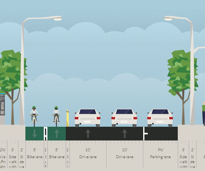
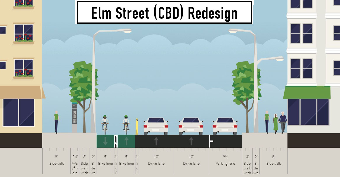
Presently Elm Street, from Central Parkway to Mehring Way, lacks consistency in its design with on-street parking located haphazardly along both sides of the street. A reconfiguration of the street could consolidate all on-street parking to the east side of the street, thus eliminating only a nominal number of on-street parking spaces, and maintain 2 to 3 moving traffic lanes (the parking lane could be restricted during rush hours to allow for a third travel lane).

The Elm Street cycle track, meanwhile, would be located along the west side of the street and be buffered from moving traffic by a row of bollards. Such a redesign of Elm Street would be a bit of a road diet, but one that seems reasonable for this stretch of overbuilt roadway.

Planners with the City’s Department of Transportation & Engineering (DOTE) said that the idea of an Elm Street cycle track had not come up before, and has not been presented to any formal committees or community councils to-date. Such coordination, they say, would need to take place prior to the idea moving forward.

With future phases of The Banks and the yet-to-be-named residential tower on Fourth Street set to begin construction soon, there seems to be an opportunity to rebuild this roadway along with those projects. This would help offset some of the costs and make for a more seamless transition.

Projects like this are low-hanging fruit for the new mayor and council, should they wish to pursue investments that improve the city’s bike infrastructure. They should work with the bike community and come up with a strategy that provides a clear path forward to make this happen.

An Elm Street cycle track like this would provide a critical link in the region’s bike network, make the street safer, more accommodating to more users and more attractive to those who currently find themselves along the now bleak and desolate stretch of roadway. Let’s get to work.

Categories
Business Development News

Short Film on Seaside, Florida Wins Award at New Urbanism Film Festival

More than 30 years ago Andrés Duany‘s urban design firm gave the world Seaside, Florida – the real life setting for the 1998 film entitled The Truman Show. Yes, that surreal place showcased in the movie to be too nice to be real actually exists on the Florida Panhandle.

The master planned community sparked a movement, called New Urbanism, for which Duany is as much responsible for as the movement is critiqued by contemporary architects.

Seaside focused on a lot of design concepts that were not necessarily new, but were novel at a time when developers across America were building strip malls, generic subdivisions and carefully segregating land uses. Some people even contend that Seaside helped to spark elements of the green building movement.

Love it or hate it, Seaside made an impact and changed the conversation about community design. While just 30 years old at the time his firm designed Seaside, Duany is no longer young, but he still energetically tours the country talking about New Urbanism and the tenets of good urban design and environmentalism.

The following video won ‘Best Urban Design Short Film’ at the first annual New Urbanism Film Festival in Los Angeles. Seaside, The City of Ideas profiles the coastal community and the basic ideas that influenced Duany’s firm. It is a great video to watch for anyone not intimately familiar with Duany or his New Urbanist movement, and perhaps a good video to watch for even the most familiar planners and architects out there.

Categories
Arts & Entertainment News Politics

William Mallory, Sr.’s Legacy Will Live on Through Family, Record and Monument

We lost a legendary Cincinnatian on Tuesday when William Mallory, Sr. passed away at the age of 82.

Mallory’s political history is profound and sparked a political empire that continues to this day through his five sons who have all continued the family business of politics. You can learn more about the Mallory family, and how William Mallory, Sr. got his start early on in the West End, in this great feature published by The Enquirer.

While the legendary 28-year state representative had been out of that seat since 1994, he continued to make an impact locally. One of his most recent contributions was the Black Brigade Monument at Smale Riverfront Park.

According to the Cincinnati Park Board, it was the Honorable William Mallory, Sr. who inspired the creation of the monument in order to ensure that the story 718 heroes from the Civil War was preserved.

“Upon reading about the experiences of Cincinnati Black Brigade several years ago, Mr. Mallory recognized the story as a rich tapestry—woven with timeless lessons of courage, the search for justice, the scourge of bigotry, and the value of human life and dignity that still speak to us today in the most profound ways possible,” Park Board officials stated in a prepared release.

The monument now stands within the first completed phase of Smale Riverfront Park near where Main Street (Joe Nuxhall Way) terminates at Mehring Way. It was completed in September 2012 and serves as a primary feature of the city’s landmark park.

The Cincinnati Park Board was kind enough to provide us with a video detailing the history of the Cincinnati Black Brigade that includes detailed explanations from William Mallory Sr. as to why the monument is important.

“Late 19th century Cincinnati educator Peter Clark was commissioned by the Black Brigade to document their story. This historical account made it clear to me that the Brigade wished for future generations to know about their contributions to the Defense of Cincinnati,” Mallory explained at the monument’s dedication just over one year ago.

“Having worked for a decade towards creation of a monument to their memory, I am pleased that its design and placement has been led by the Cincinnati Park Board and Cincinnati Parks Foundation. This monument secures Cincinnati’s Black Brigade its proper place in history.”

It is certainly cold outside, but if you have yet to visit the Black Brigade Monument, this is probably a good time to go and experience it for yourself. Perhaps even thank Mr. William Mallory, Sr. for his inspiration and leadership on the matter while you’re there.

There will also be a public service held at the Museum Center at Union Terminal on Sunday, December 22. Those who are interested in attending the celebration of William Mallory, Sr.’s life may do so by submitting an RSVP online.

Categories
Development News Transportation

UC Planning, Engineering Students Propose Hamilton Avenue BRT Corridor

Hamilton Avenue BRT CorridorLast fall UrbanCincy partnered with the Niehoff Urban Studio on an event that highlighted the work of an interdisciplinary group of students. That semester engineering and planning students focused on urban mobility and looked at bikeways and bus rapid transit ideas within the city.

Each of the student groups presented their final research and findings to fellow academics and industry experts from around the region. We then gathered a group of transit and bike experts to engage in a panel discussion about the student’s proposals and about transportation in the region in general.

Throughout the course of the day, we asked members of the public who attended to vote on their favorite proposal. The winner was a bus rapid transit corridor along Hamilton Avenue that focused heavily on a transit-oriented development (TOD) in Northside where The Gantry is now being built.

The six-person team consisted of Tyler Kiefer, Benjamin Lafferty, Christopher Murphy, Michael Orth and Michael Walsh from the College of Engineering & Applied Science and Alexander Cassini from the College of Design, Architecture, Art & Planning.

First and foremost, the group said that their Hamilton BRT Line would most closely resemble Cleveland’s highly publicized HealthLine, which is the highest-rated BRT line, by far, in North America. The group also examined lines in Pittsburgh and Kansas City.

One of the main reasons for the comparisons to Cleveland is the similarities between the corridors. In both Cincinnati and Cleveland, the corridors connect neighborhoods under-served by transit to institutional services, while also providing greater mobility.

“The 2010 U.S. Census has shown how the population along Hamilton Avenue has less access to quick and reliable means of transportation when compared to the stats of Cincinnati and Ohio as a whole,” explained Masters of Community Planning student Alexander Cassini. “This lack of mobility directly affects citizens’ access to essential services and employment opportunities.”

Their research found that Metro’s #17 bus route, which most closely aligns with their proposed BRT corridor, currently averages weekday ridership of about 4,500 people. Furthermore, they found that approximately 17% of the households along the corridor have no car, 10% of the commuters identify as bus riders and there are 6,387 people living per square mile.

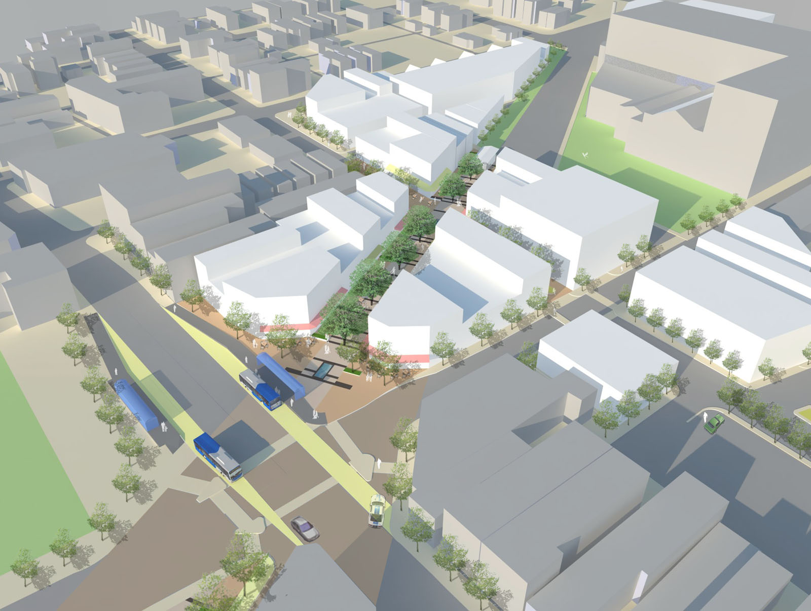
The proposed BRT corridor runs from Downtown to North College Hill, and the engineering and planning students saw this particular corridor as a major opportunity to spread investment and attention from the center city to additional neighborhoods that would take advantage of the BRT route’s 12 stations spaced out between one-half mile to three-fourths of a mile apart that would ensure faster and more efficient service. Each of the 12 station locations, Cassini notes, was selected due to its significant population and employment nearby.

“Northside and North College Hill are historic places in the city and present a great opportunity for Cincinnati to keep growing as a city,” noted civil engineering student Michael Orth.

Orth went on to say that while one of the positives of this corridor was the amount of people and businesses it could positively impact, the area’s congestion was also one of the team’s greatest challenges, stating, “There is very little room to implement a bus only lane throughout the corridor, which would be ideal for a BRT line.”

To help address this situation the group said that they envision a bus only lane, or a hybrid lane for buses and cars depending on the hour, through the congested portions of the route. Although not recommended, if a hybrid lane was determined to not be satisfactory Orth said that further study could be done to examine whether there would be enough benefit to remove on-street parking in order to provide for a consistent, dedicated bus only lane.

Other technology to help facilitate the quick movement of buses along the corridor would include arrival detection at traffic signals so that the lights can change in order to accommodate an approaching bus.

Existing Metro bus service, they said, would largely be redeployed to avoid redundancy, but some would remain since local buses stop more frequently – potentially creating a corridor of localized bus and express BRT service.

Hamilton Avenue BRT in Metro*Plus Context
One area where the Southwest Ohio Regional Transit Authority (SORTA) has already begun enhancing bus service is along Montgomery Road, which connects Downtown with the Kenwood area. That new Metro*Plus service, while not full BRT, is a step in the right direction according to the University of Cincinnati students, and has already seen ridership triple since its upgrade.

“Metro*Plus service is good but it is only the first step towards a true BRT system for the Cincinnati metropolitan area,” Cassini cautioned. “Metro*Plus service can be even more efficient, and effective if totally dedicated lanes and other additional features are added.”

Reading Road, where Metro began operating articulated buses in 2010, is actually the region’s most heavily utilized bus corridor with Hamilton Avenue coming in second and Montgomery Road third. If Metro is to continue to build out its enhanced bus service, or full-on BRT operations, then Hamilton Avenue may very well be the next logical choice.

What helped the group’s proposal stand out from other presentations was its focus on the TOD in Northside. With a $13 million mixed-use project coming out of the ground on that site now, the group reflected on their own proposal.

While the team had collectively noted the large, clean open space as being one of the huge benefits of the site, it also made it particularly valuable in their opinion. As a result, several of the group members, while encouraged about the private investment, were also a bit underwhelmed by the Indianapolis-based Milhaus Developers’ architectural design.

Both Cassini and Orth mentioned that they would be interested in working full-time in the transportation industry someday, but for different reasons. When asked to briefly compare the wide variety of transportation projects current in the planning or development stages around the region, there was a uniform response that their excitement is for the Cincinnati Streetcar.

“Although the planned streetcar line does not expand sufficiently in our eyes, we believe it would be an incredible economic development booster for Cincinnati’s downtown and overall urban core,” Cassini explained. “The overall transportation efforts around Cincinnati will eventually pay off to form a comprehensive and more easily navigable system than today.”

The Niehoff Urban Studio is currently working with a new set of students on designs for the Wasson Corridor, which runs through several of Cincinnati’s eastern neighborhoods. This is another topic that was examined by one of the interdisciplinary groups of planners and engineers last year. UrbanCincy is once again partnering with the Niehoff Urban Studio and will be organizing a similar showcase and panel discussion in 2014.
Categories
Up To Speed

What does the Astrodome mean to the movement to preserve modernism?

What does the Astrodome mean to the movement to preserve modernism?.

After losing at the ballot box, the Astrodome appears to be on life support as pressure mounts to tear down the vacant engineering and architectural marvel. To some this is representative of the ongoing preservation battle being waged on behalf of modernist architecture. To other’s it is purely economics. Should we, as a people, be working to preserve objects from the modernist movement, and how exactly does the iconic Astrodome fit into that equation? More from NextCity:

Has the nation made the Astrodome into a powerful and motivating symbol of modernism’s plight? No, but that actually shows a positive acceptance of the style. Few media reports of the referendum this week even discussed the building’s style, let alone the usual quibbling over appreciation of modern design. Reporters quoted voters more concerned about the cost of the proposed renovation. The vote went down peacefully, without much of the palpable outcry that led to the recent preservation victory for Hilario Candela’s Miami Marine Stadium.

[…]

Until its closure in 1999, the Astrodome was the broadcast setting to mainstream sporting events, concerts and oddities like daredevil Evil Knievel’s jump over 13 cars in 1971 and Bobby Riggs and Billie Jean King’s tennis match (the “Battle of the Sexes”) in 1973. Most recently, the mighty structure seared itself into the epic and unresolved recovery narrative of Hurricane Katrina. Thousands of refugee Americans made the Astrodome into a camp in 2005, turning the stadium into a panopticon of despair.