Categories
Development News

Newport’s Southshore condominium tower promises life, luxury, fantastic views

Newport saw the completion of its first high-rise tower when the 21-story SouthShore condominium tower began welcoming residents over a year ago. With much of the tower now occupied, UrbanCincy was invited to tour the dramatic riverfront building to see where it stands now.

The building soars 240 feet above Newport, overlooking the Daniel Carter Beard “Big Mac” Bridge and downtown Cincinnati. SouthShore’s 61 luxury condominium units range in size from 1br to a 5,000 square-foot penthouse that encompasses the entire 21st floor. Condominiums range from $395,000 to $3.3 million for the large penthouse unit.

One of the most unique features of the SouthShore tower is its front loaded design that allows each unit to face north toward the Ohio River and downtown Cincinnati – a common design approach in high-end, waterfront residential towers. The building was intentionally designed with all of the mechanical features facing away from the river so that all the residents have stunning views of downtown, Mt. Adams and the river. Each unit also features a terrace, which range in size from a modest sitting area to an enormous 3,000 square-foot outdoor terrace for the penthouse.

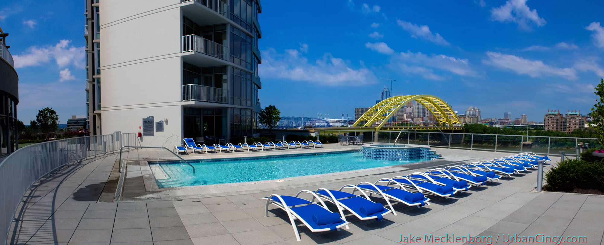
With potential flooding being a concern for the structure, architects designed the building to be integrated right into the levee. The first four floors of the structure is a parking garage for residents and visitors, which feature two sets of floodwalls. If the City of Newport must shut their floodwall to protect the city from rising waters, residents at SouthShore can still exit from the complex’s private floodgate. The building then narrows as it rises from the garage, creating ample rooftop deck space for a swimming pool with fountains and a hot tub, an 1,800 square-foot fitness center, putting green, walking trails, gardens, and a two-level clubhouse for residents.

On the ground level, many of the residents use a secure storage area for their bicycles and segways. The building management is also looking to purchase two segways for residents to use at their leisure.  Many residents walk to Kroger in Newport, spend time at Newport on the Levee, or walk or bike into other parts of Cincinnati. It is just a ten minute walk from SouthShore to The Banks development on the other side of the river. Realtors from Sibcy Cline also speak highly of the building’s soundproofing which allows residents to enjoy peace and quiet despite sharing walls with their neighbors.

Capital Investment Group, the project’s developer, has plans to build a similar tower next door to SouthShore called The Marina. This residential tower is planned to feature many of the same amenities with the addition of private dock space for homeowners in the new 100-slip marina approved by the US Army Corps of Engineers early in 2009.

Those interested in obtaining more information about condominiums at SouthShore can contact Christine Schoonover with Sibcy Cline at (859) 431-8000 or CSchoonover@sibcycline.com. When you speak with her, mention that you read about the condos on UrbanCincy.

Categories
Development News Transportation

Streetscape projects helping transform Fort Thomas business district

The bedroom suburb of Fort Thomas, Kentucky is perhaps best known for its streets of tidy, well-kept houses and its nationally-ranked public schools. Located along a ridge overlooking the Ohio River and downtown Cincinnati, Fort Thomas is an attractive destination for those seeking the relative peace and quiet of a suburban lifestyle, combined with convenient access to downtown Cincinnati along with walkable streets and plenty of historic character.

In recent years, Fort Thomas has become one of several Northern Kentucky cities seeking to enhance its appeal by revitalizing its historic retail district and rediscovering the benefits of pedestrian-scaled, transit-friendly urban development. Fort Thomas’s neighbor to the north, Bellevue, has received recognition for its ongoing historic preservation work, and Bellevue and Covington have both made strides in implementing form-based codes that could ultimately serve as a model for zoning code changes in Cincinnati.

Over the past few years, Fort Thomas has undertaken a number of projects to enhance the city’s role as an attractive community within Cincinnati’s urban core. These projects include new buildings for Highlands Middle School and Woodfill Elementary School, a new amphitheater and bike trails in Tower Park, and the restoration of the city’s iconic 100-foot-tall stone water tower at the entrance to Tower Park. Perhaps most visibly, though, the city of Fort Thomas has recently completed major streetscaping improvements to its primary business district centered around the intersection of Highland and Fort Thomas Avenues and its secondary business district — the so-called Midway district — located adjacent to the site of the former Army post.

Aspects of the two streetscaping projects included burying overhead utility lines, the reconstruction of sidewalks and crosswalks to include brick accents and other decorative elements, the addition of street trees and thoughtful landscaping, installation of pedestrian-scaled light fixtures and signage, as well as the introduction of benches and other outdoor seating. The first phase to be completed was the primary downtown district at Highland Avenue and Fort Thomas Avenue.

Now complete for a couple of years, the trees and plantings in downtown Fort Thomas have begun to nicely mature. Of particular interest is the focus on the former Green Line streetcar, which provided transit access to the Army post and served as a catalyst for much of the subsequent development in the city from the 1890’s through the 1950’s. Fort Thomas is the classic “streetcar suburb”, and today’s TANK bus route through town still carries the Green Line’s old #11 route number.

Following the completion of streetscaping improvements to the downtown district of Fort Thomas, the second phase involved similar improvements to the so-called Midway district, a secondary business district on South Fort Thomas Avenue that grew up adjacent to the former Army post and was named after the carnival midway at the 1893 World Columbian Exposition in Chicago. The site of the Army post — originally built to replace the flood-prone Newport Barracks — is now home to Tower Park, a large Veterans Administration nursing home, and an Army reserve center.

The streetscaping improvements recently completed in the Midway district are similar in nature to those performed in downtown Fort Thomas. Included in the Midway improvements were the reconfiguration of the River Road intersection, which now provides a small civic space that can be used for outdoor concerts or a farmer’s market, and the addition of sidewalk seating for neighborhood establishments such as the Olde Fort Pub and the Midway Cafe.

There are still a number of vacant storefronts in the Midway district, but it is hoped that the now-completed streetscaping improvements along with other measures, such as the restoration of long-vacant officers’ housing nearby and marketing efforts by the newly-formed Renaissance District, will see the addition of new retail tenants to the Midway district.

Categories
Development News Politics Transportation

Reconstructed Fort Washington Way generating variety of societal advances

Each Wednesday in July, UrbanCincy is highlighting Fort Washington Way (FWW), the I-71/US-50 trench bisecting the Cincinnati riverfront from its downtown.  Part one of the series discussed what the area looked like prior to reconstruction a decade ago, and how that reconstruction made way for the development along Cincinnati’s central riverfront.  Last week’s article discussed some of the unseen assets included in the project that continue to benefit Cincinnatians in a variety of ways today.  This week’s piece will highlight even more of the unique features that the 1.25 mile-long highway boasts.

In addition to the combined sewer overflow fix along Cincinnati’s central riverfront through added containment capacity, engineers also increased the capacity for municipal water under Third Street.  This led to an opportunity for the City of Cincinnati to share its high-quality water supply with communities in Northern Kentucky through a new tunnel built underneath the Ohio River.  Those in Kentucky benefit by receiving clean water, and the City of Cincinnati benefits from an increased revenue stream.

On the southern side of the FWW trench is a wall that supports Second Street and conceals the Riverfront Transit Center, but it also serves as the primary flood protection for downtown Cincinnati.  Cincinnati choice to build its flood protection into its everyday infrastructure maximizes utility while also conserving urban space.  Since this wall was engineered to lift Second Street above the floodplain, it effectively extended the street grid south while also maintaining safety.

The benefits discussed so far were not accomplished in isolation.  In fact, the reconstruction project was helped paid for by entities in the state of Kentucky including the Transit Authority of Northern Kentucky (TANK) who saw better connections with Cincinnati as an economic gain.  The project fixed the entanglement of on- and off-ramps to the bridges over the Ohio River, and has led to a better transfer of people and goods across the state line.

The fact that the Cincinnati area calls so many large and lucrative companies home demonstrates that the city once had the ability to draw major economic players to the region.  The fact that they have stayed demonstrates that the area has done well to keep up with changing business, technological, and infrastructure demands.  One such example of keeping up with changing times can be found buried under Third Street, behind the northern wall of Fort Washington Way, where engineers included the capacity for a bundle of fiber optic cables, approximately three feet in diameter, spanning the length of the roadway.

This dark fiber has the capability to be activated and connected with a larger fiber optic network when needed, ensuring that downtown Cincinnati has the ability to stay at the cutting edge of technology.  Possible uses include connecting large-scale data centers to the Internet backbone, or providing high-speed fiber-to-the-home Internet access for Cincinnatians, such as Cincinnati Bell’s FiOptics or Google’s Fiber for Communities.

Next Wednesday’s article will conclude the series, and look to the future of the area.  What can be done with the space over the FWW trench in terms of the capping?  How will future development be impacted?  And, ultimately, will the reconstruction of Fort Washington Way reestablish the strong ties that once existed between Cincinnati and its riverfront?

Categories
Development News

$14.4M Red Cross headquarters poised for LEED-Gold certification

When the Cincinnati Region of the American Red Cross celebrated the opening of a new $14.4 million Disaster Operations Center in Evanston last month, local leaders and community members were celebrating much more than new and improved facility, they were celebrating a new and improved facility that focuses on sustainability.

Designed by Cincinnati-based emersionDESIGN, the new 45,000 square-foot facility includes a variety of sustainable features like low-flow water fixtures that reduce water consumption by 40 percent, high-efficiency glazing and well-insulated wall cavities, bike racks and showers to promote eco-friendly transportation, sensor lighting and controls to reduce energy use. Outside the structure developer Neyer Properties included bioswale and rain garden systems to decrease impact on the storm water system, use of native landscaping to reduce irrigation, LED parking lot lights, an energy recovery ventilation, and a green roof.

In addition to the building features, the development team used more than 30 percent recycled material on the project, 40 percent regional materials, used woods certified by the Forest Stewardship Council, and recycled over 75 percent of construction debris from the site. The team expects to hear back on their Leadership in Energy & Environmental Design (LEED) application by the end of 2010, but it is widely expected that the structure will achieve LEED-Gold certification.

“As the design developed, it became apparent to us that we could move up in LEED rankings,” said Charlie Pond, Building Development Director, Neyer Properties. “It was a joint goal between Neyer Properties and the Red Cross to create a sustainable building, and we were emphatic about being environmentally friendly.”

The green roof incorporated into the building’s design covers approximately 25 percent of the total roof area. The sedum plants covering the roof area minimize the need for heating and air conditioning by reducing the amount of heat the building absorbs in summer and conserving building heat in winter.

Officials with the Red Cross believe the structure has approximately a 50-year lifespan for their purposes. The sustainable design features, meanwhile, are expected to have less than a five-year payback period through annual energy savings of 30 to 35 percent, meaning big savings for the non-profit.

“It’s great to work with emersion because of their large number of LEED Accredited Professionals. They are very familiar with green projects and they have similar goals as us,” Pond concluded. “We feel that developing sustainable projects the right thing to do, and we want to get Cincinnati caught up-to-speed on the green building movement.”

Categories
Development News Politics

Properly implementing form-based codes is essential to success

[This op-ed was originally published in the Cincinnati Business Courier on July 9, 2010. Visit the original op-ed for more comments, thoughts and opinions on how to effectively apply form-based codes – Randy.]


As Cincinnati officials move closer toward their goal of implementing some variation of form-based codes in Cincinnati it is important that the application is done correctly. Form-based codes, when done correctly, offer a simpler approach to land planning than their awkward land use/design overlay contemporary. In order to achieve the full benefits of a form-based code there are a few practices that should be followed.

Keep It Simple:
The problem with contemporary zoning codes is that they feature layers upon layers of regulations that are complicated to understand by the general public and developers. Most zoning codes have an underlying Euclidean Zoning Code which regulates land use and basic design elements like building setbacks, heights, and densities. Then in the more stringently regulated areas there are often overlay districts created that layer an additional set of regulations on top of the land use regulations. These overlay districts tend to focus more on design features within a given area, and allow any land use regulations that are not covered in their guidelines to fall back into the realm of the underlying zoning code.

The primary functional gain of form-based codes is that they presumably eliminate this layered zoning effect that creates confusion. As a result, form-based codes should NOT be implemented in a layering manner. Form-based codes should completely replace any existing overlay districts and all land use zoning codes that currently exist in the area. The end result would be a district that has only a code that regulates the urban form of an area without the constraints of land use controls and the arbitrary design standards set out therein.

The reason this is often not done is due to a fear that form-based codes will not have the teeth to prevent communities from being destroyed by “undesirable” uses. I assert that this fear is misguided as our current zoning practices were set out during an industrialization period in the United States that saw many polluting industries locating in or around residential neighborhoods. This is certainly not what is desired, but this will not occur in modern society for two main reasons.

  1. Industries locate based on transportation access. An industrial user will seek out access to freight rail, barge, air, and truck access, and as a result, this will eliminate the vast majority of our residential neighborhoods from consideration as they have self-selected to locate in areas away from these industrial amenities.
  2. If a form-based code is done well an “undesirable” will often not be able or willing to locate in a higher transect district. A good example would be Cincinnati’s T6 “Urban Core Zone” where presumably a coal cleaning facility could set up shop due to the lack of land use controls, but if it were to open, the coal cleaning facility would have to design its facility to fit the form of that found in the T6 Urban Core Zone. Such a form would not only be undesirable for such a use, but it would also be cost-prohibitive for its business function.

Forget the Piecemeal Approach:
Many form-based codes are applied in a piecemeal approach that selectively implements the form-based controls in a particular neighborhood or business district. In the Cincinnati region this is presently being done in both Bellevue, KY and Covington, KY as those cities incorporate form-based codes of their own.

The problem with this approach is that it ignores the all-important transect for which a form-based code is derived. The piecemeal approach allows for the individual form-based codes to be developed in an insular manner without taking into consideration the form of the urban region.

The reason this is problematic is that form-based codes are meant to be living, breathing creatures that can change as a community changes. Cincinnati’s center city has not always been as densely built as it is today, and it got to this point by growing and changing over time. This means that a code that can change with the city is more ideal than one that cannot. If a neighborhood or business district wants to evolve upward from T4 “General Urban Core” to a T5 “Urban Center Zone” it should be able to do so, but if that individual form-based code is developed without these other districts in mind, it prevents such evolution from taking place.

Form-based codes offer a variety of tangible benefits, but they can only fully be realized if we leave the fear of the unknown behind and truly take a risk on something bold and new. No major American city has embarked on such a dramatic reform of its land-planning techniques, but what better city is there than Cincinnati – where modern planning was first implemented – to explore such an effort?