Categories
News Transportation

How to Reimagine Our Streets Around the Concept of Shared Space

CNU22 featured speakers from all over the world, from Bogotá to Toronto to Brighton. One plenary speaker from Bristol moved the audience with an idea called Shared Space that was beautifully simple and innovative, yet entirely new to most of the crowd.

Ben Hamilton-Baillie is a British urban designer, “recovering” architect and self-taught in the area of transportation planning. His presentation focused on explaining Shared Space as an urban design technique that can alleviate the frequently problematic interface between pedestrians, cyclists, automobiles and the public realm.
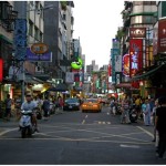
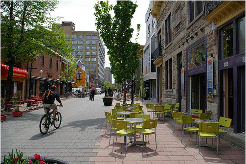
As the name would suggest, Shared Space advances the idea that streets themselves can be a seamless part of public space that is shared by all users. The method came from the Netherlands, where Hamilton-Baillie studied under transportation engineer Hans Monderman and Joost Váhl, who developed the Dutch woonerfs where pedestrians and cyclists have priority on roadways.

The concept also integrates a thoughtful assessment of human psychology as it relates to driving. “It’s essential to understand the changing view of the nature of risk,” Hamilton-Baillie explained. “Hazards keep us aware of our environment and allow us to adapt our behavior.”

This seems counter-intuitive, but it was effectively explained through an example of two cities in the Tel Aviv region of Israel.

Bnei-Brak, located east of Tel Aviv, is composed of largely low-income, ultra-conservative Jews. Ramat-Gan, also located east of Tel Aviv, is home to a more moderate, middle-income Jewish population. Hamilton-Baillie explained that the people of Bnei-Brak are known throughout the region as being unruly pedestrians. Adults and children cross streets with disregard for traffic. Locals know that they must be vigilant when driving there.

Conversely, the residents of Ramat-Gan respect pedestrian rules, crosswalks, and jaywalk less frequently. Drivers are more at ease in Ramat-Gan.

Perhaps counter-intuitively, there is a higher instance of pedestrian fatality in Ramat-Gan. Drivers in Bnei-Brak tend to cautiously drive at lower speeds, aware that there is a greater risk of a pedestrian appearing in the road. One can see in this example that increased risk makes for more attentive drivers.

Shared Space utilizes risk in the form of mixing cyclists, pedestrians and motorists on streets, and relies on the idea that removing lines and signaling allows for social protocols to take over more strongly than signs. This, Hamilton-Baillie said, is called “friction”, or natural cues that guide a driver’s speed. There is already an increasing awareness in North America that things like narrow streets, street trees and buildings built to the right-of-way naturally induce drivers to reduce speed without a speed-limit.

One might think that this friction would create delays, but evidence from project implementation has found the opposite, as did Hans Monderman’s projects in the Netherlands. And post-project evaluations, like in Poynton, UK, have confirmed the efficacy of Shared Space designs.

Poynton is a city southeast of Manchester. It is a throughway for traffic between the two larger cities of Macclesfield and Stockport. In this instance, vehicles were found to be passing on the main thoroughfare at a rate of 26,000 per day, many of which were trucks. The initial approach to relieve congestion was the construction of additional lanes of traffic.

Shared Space, however, was applied as part of a regeneration scheme in Poynton. The first task for Hamilton-Baillie’s consultancy was to “remove every trace of traffic engineering.”

Three lanes of cars were reduced to one, signaling was removed, additional on-street parking was introduced, and sidewalks were widened. There was increased edge friction through vertical elements within the driver’s line of vision.

Even after the removal of two lanes and signals, traffic flow stayed the same and pedestrian traffic increased five-fold. Before the project, 16 of 32 shops in town were boarded up; but within one to two years after project completion, all shop spaces in the business district were occupied.

Streets were able to concurrently be part of Poynton public space and serve through traffic – the change in aesthetics was remarkable.

It is certain that freight and car movement is critical to the healthy functioning of any economy. This fact is not contested. But since civilizations started building cities, they have been venues for people to roam – sometimes at odds with our economic necessity to move people and goods through them quickly.

Fast big things and slow small things do not mix well.

Shared Space demonstrates that these seemingly incompatible users actually function better when mixed within the city fabric – cars move more fluidly when drivers are forced to react to their surroundings instead of their actions being dictated to them. People are safer, too.

The outcome is that streets become a different kind of public space, where mobility means interacting with one’s surroundings.

When asked if he thought famously impatient North American drivers could adapt to the concept, he paused for a moment and said, “Everywhere Shared Space has been applied, I was told that the drivers in the locale couldn’t adapt. In every case they did.”

Categories
Business Development News

What Influence Does Population Density Have on Neighborhood Improvement?

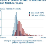
Data from the Cleveland Branch of the Federal Reserve Bank shows that a poor neighborhood’s income growth, while affected by internal factors, is also highly influenced by its surrounding metropolitan area.

Much the same that a poor family in a strong neighborhood is more likely to be lifted up by the rising tide in their neighborhood, it seems that poor areas of cities have the ability to function in the same manner.

The data from the Federal Reserve measures neighborhood growth, or lack thereof, from 1980 to 2008. Several statistics from the report come as a surprise.

First, while the report finds that a neighborhood’s percentage of residents with a high school degree, bachelor’s degree, and its unemployment rate in 1980 all have some correlation with that neighborhood’s chances of having income growth, the statistics are not all that strong.

The difference in bachelor’s degrees between neighborhoods with no income improvement and those with a high degree of income improvement was around 3%. Meanwhile, the unemployment rate was only about 2% lower in high income growth neighborhoods.

But perhaps the most striking evidence, at the local level, is how much population density correlates with a neighborhood’s likeliness to achieve high income growth.

Neighborhoods that had no improvement had, on average, a density of 12,028 people per square mile in 1980, while neighborhoods with high improvement had an average density more than double that of 30,399 people per square mile.

The City of Cincinnati, by comparison, has a population density around 3,810 people per square mile.

By 2008, the change is stark. Neighborhoods that received high income growth increased their educational attainment, population and population density at a much higher rate than what the report classifies as no-improvement neighborhoods.

The report also found that poor neighborhoods in low-growth metropolitan statistical areas (MSA) were more likely to remain stagnant or even shrink while poor neighborhoods in high-growth MSAs had a higher chance of experiencing income growth.

Growing at just 0.4% annually since the 2010 Census, the Cincinnati MSA would fall into that low-growth category.

While the average income of an MSA in 1980 may not be a good predictor of whether a neighborhood will experience high or low growth, neighborhoods that experienced high income growth were located in regions that experienced higher growth in income, a growing population and increased their population density.

As a result, two identical poor neighborhoods in New York City and Cleveland in 1980 would look much different in 2008, despite being in the same position 38 years prior. The assertion is that a growing metropolitan area has a tendency to lift the tide for all neighborhoods.

The Federal Reserve Bank of Cleveland points out, however, that some of this improvement in high-growth neighborhoods could be due to what they deem residential sorting; basically, changing demographics in the neighborhood.

While the evidence is not certain, the data also shows neighborhoods that experienced high-growth from 1980 to 2008 were also more likely to have gained residents (10%) than low-growth neighborhoods (-20.9%). Therefore, neighborhoods that experienced high growth were those that also had the greatest opportunity for demographic shifts to occur within the neighborhood.

Interestingly enough, while much of the gentrification argument has centered on white residents pushing out minorities, the report found that neighborhoods that experienced high growth rates were more likely to reduce their share of black and white residents, while increasing their share of Hispanic residents.

These trends have wide implications for American policy regarding poverty and urban development, but appear to be less relevant in the Cincinnati region where very few neighborhoods have any sizable Hispanic population.

With this strong evidence indicating population density is linked to a poor neighborhood’s ability to improve, it only reinforces the growing narrative about the suburbanization of poverty in America.

Still, however, there is a long way to go before this narrative is fully realized locally; as it is estimated that roughly half of all children in the City of Cincinnati live in poverty – a number that does not appear to be changing.

While policy makers at City Hall will surely be discussing youth jobs programs, career training, early childhood education and neighborhood health centers, one other item on the policy agenda should be the urban form of our region’s neighborhoods.

We do not know whether higher population densities were a cause or merely correlated with a neighborhood’s ability to improve, but we do know, thanks to this data from the Federal Reserve, that the two issues appear to be more connected than what we may have previously thought.

Categories
Business News Opinion

GUEST EDITORIAL: The Mathematics of Urbanity

There are many ways by which you can measure progress but there’s nothing like defining urbanity to put into perspective just how far along societies has come. Urbanity, after all, encompasses everything modern and progressive, the leaps and bounds that humankind has made through the years to essentially live better.

It’s in the trends of condos and high buildings. It’s in the gadgets and devices you carry around. It’s in the very air you breathe. Different people have different needs but it cannot be denied that everyone benefits from urbanity at some point or another.

That condo you’re living in? That’s a result of urbanity. As well as your favorite coffee shop and the latest flick they’re showing in a cinema near you. It’s around you and will continue to persist for as long as an individual interested in improving how one lives exists.

Defining Urbanity
What is urbanity? At the heart of it all, it is basically the refinement of experiences. If you think about it, anything urban is simply the better version of something else in a rural setting. If you think about living conditions, for instance, you’ll see a fine example in condo living.

Where living in a condominium can be considered as the pinnacle of comfort, luxury, and convenience in an urban area, the rural end of the spectra will show housing options of drastically lower quality. There is urbanity where there are jobs. There is urbanity where commercial structures abound. There is urbanity where modern living is applied. It is usually associated with large cities because their massive economic strength makes it possible for urbanity to thrive. It also usually paints a picture of glass and metal, starting full of promise but eventually fading into a backdrop of smog and gray skies.

Urbanity represents the good, the bad, and the ugly about progress. Identifying the bad and the ugly seems to be foreboding but this does not mean that all things urban are doomed to ruin eventually. True progress, and consequently true urbanity, has to do with finding solutions to everyday problems, making it easier for an ordinary citizen to wake up in the morning and go about their day.

This includes finding a balance between green architecture and innovative architecture, allowing cities to not only thrive with technology but to co-exist with the environment as well.

The Urbanity Equation
For the longest time, the urban setting has always followed a simple equation where you subtract green space when skyscrapers and others have to be added to the landscape. As such, as buildings and other structural feats filled the cities, lush greenery started to fade, until you’re left with nothing more than a few hardwoods used as accents. This pervaded until the disastrous effects of climate change started making themselves felt, making it known to every person that the environment will not take its destruction sitting down.

Calamities and disasters are clearly eye-openers that’s a why a more enlightened consciousness began to form, giving birth to architectures adapting to the needs of the times. People are increasingly becoming aware that their actions have consequences and that the results aren’t pretty. Fortunately, it’s not too late.

Mankind has done a great deal of damage to the planet but it is not too far gone that nothing can be done to remedy the situation. But if these efforts are to have a lasting impact, they have to be implemented at the soonest time possible while following a logical plan of action. After all, the sooner sustainability trends catch on, the sooner damages can be softened if not completely reverted.

If you’re looking for a home in the sky, for instance, make sure you go with a condominium that employs green technologies in their property, like energy-saving measures. Aside from automatically helping you do your bit for the environment, green architecture has impacts on energy use so this helps you save on costs because overall resource consumption in your building will be reduced. You’ll see this when you calculate condo cost. A portion of your condominium dues accounts, after all, for your share in the upkeep and expenses of the building so lesser expenses means smaller monthly fees for you to pay. Saving money while saving the environment? Not a bad idea at all.

Does It Add Up?
Ask anyone and most people will tell you that they still appreciate urbanity, what with the conveniences it offers in many aspects of day-to-day living. It’s definitely understandable because there are just many things in your life that you wouldn’t want to go back to after having seen what a better way is like. But in your aim to amass the better things in life, are you sure the trade-off is worth it? Sometimes, it’s just not.

Green living is a little bit easier today because property developers have taken it upon themselves to introduce sustainable and environment-friendly features in their projects. But just because your building recycles water doesn’t mean that you’ve done enough of your part in taking care of the environment. You have to take a more active role than that.

You have to think beyond what your actions will mean tomorrow, next week, or next month. You have to consider what your actions will lead to years in the future, when a different generation is walking down the very streets you walked on. Are you leaving them a livable world? No one can really say what will happen in the future but having the future in mind in whatever you do today will help ensure that there is indeed one to look forward to.

Putting Two and Two Together
The modern world will always have a certain level of flashiness to it but there is hope that it wouldn’t be as bright as before, a time when people are blinded to the realities and consequences of urban living. By turning down the lights bit by bit, people are able to see more clearly where the brazen path to the urban realm is really leading to (not that it hurts to save on energy costs at the same time).

Calculate condominium expenses and you’ll get an idea as to how much living in the lap of luxury will cost you. But is that amount really all you have to pay to enjoy a life of convenience? Costs can come in various forms and most of the time people are not willing to pay what it takes to get what they want. Worse, they don’t want to pay anything at all. Nothing in life is free and it’s this kind of greed and selfishness that got everyone into trouble. The sooner people find a way to balance their needs and wants with that of the planet’s, the sooner they’ll be able to truly make the most out of living in an urban landscape.

Urbanity is not evil. Don’t fear endless urbanity. There’s no need to fall into a zero-sum mentality when everyone can emerge as winners. It will require work but green urbanity is more than doable.

Anna Rodriguez is a Project Consultant for various real estate developers. She has a degree in Industrial Engineering and currently lives in the Philippines. She has also backgrounds in online marketing, social media management, and is currently a writer for Agency Post, and owns Homey Guide Blog.

If you would like to have your thoughts and opinions published on UrbanCincy, simply contact us at editors@urbancincy.com.

Categories
News Opinion Politics Transportation

CNU 22: Ken Greenberg Outlines Challenges to 21st Century Urbanism

The opening plenary of the 22nd annual Congress of the New Urbanism opened to an audience of over one thousand attendees. Keynote speaker Ken Greenberg, a Toronto based urban designer and author of the book Walking Home: the Life and Lessons of a City Builder addressed the audience. His message is that even though New Urbanists have accomplished much in the 22 years since the founding of CNU, there is much to do and that new urbanists need to change to meet the coming challenges of the 21st century.

Greenburg highlighted the many challenges facing urbanism today. The first is the oft cited decline in the use of automobiles. “We are seeing the back of cars,” he told the crowd. Total miles traveled is down and young people are delaying getting their drivers licenses at a significant rate compared to a generation earlier.

Second is the growing gap in income inequality between urban places and suburban places. In Toronto from 1970 to 2005 a majority of the city’s low-income population moved from the urban core to suburban communities while the core experiencing prosperity.

Greenberg CNU22Ken Greenberg addresses the CNU. Photo by Paul Knight.

This divide is happening in cities across North America as urban cores have become desirable, and suburban areas experience decline. These trends were reported by UrbanCincy last month in Atlanta.

Greenberg goes on to say that this growing divide is also resulting in a political divide where urban places are not politically strong enough to demand for better urbanism because in most cases political power is still held in the suburbs and rule areas. As money grows scarce, money for urban areas dwindle. Urban areas are increasingly competing against the suburbs for scarce national resources. This is a familiar issue in many cities, including Cincinnati.

“All things public are under intense stress,” Greenberg argues, “just when we need them the most.”

Greenberg’s message to political leaders is, “There can be no national vision without a vision for cities.” Politicians should eliminate the “perverse subsidies” that continue to encourage costly, difficult to adapt and non-resilient infrastructure.  He equates changing the direction of what he called the “sprawl industrial complex” to trying to turn an aircraft carrier: It will happen slowly.

The divide is allowing cities to both create good urbanism and bad urbanism because policy is so hard to change, good urbanism is often done by granting exceptions to policy.“We have plenty of examples of good urbanism. The challenge is to change that from being the exception to being the rule,” he told the crowd.

However the challenges remain tough.  Greenberg urges that urbanists need to stop operating in silos and unite to build good policy. The threats of climate change and an increasingly urbanized world mean that cities are a necessary part of the future. He argues that we should embrace them and build them right.

Categories
News Opinion Transportation

PHOTOS: The Impressive Urbanity of Colombia’s Third Largest City

If Medellín is the clean, gem of Colombia, Cali is the working man’s town. Visibly grittier than Medellín, Cali sports an incredible amount of assets that match and sometimes outshine Medellín.

Surrounded by mountains on one side, Cali’s skyline is more impressive than that of Medellín, while also seeming more original. Everything in Medellín is new, it seems.

While no rail transportation exists in the city, a large and extensive system of bus rapid transit allows traveling easy. In addition to their bus rapid transit system, Cali also has a system of bike lanes, although no bike share system.

They have impressive grand boulevards and arterials all throughout the city as well as grade-separated highways more impressive than those I saw in Medellín. In the downtown area, the city capped over a highway running along the river and made it a pedestrian and bus-only boulevard, following the river on the left and providing easy access to the center city and many historical buildings.

For a city with a reputation as being dangerous, it was incredibly efficient and had an impressive number of assets, including an incredible park system affording many breathtaking views of downtown Cali and the city sprawled out around it.

In the first official episode of The UrbanCincy Podcast, we were joined by Natalia Gomez Rojas, a city planner from Bogotá, to discuss Colombia’s pursuit and implementation of bus rapid transit. The discussion also touched on a number of societal issues facing Colombia’s cities as they continue to develop and evolve in a post-drug cartel era. You can subscribe to The UrbanCincy Podcast on iTunes for free. You can also read more of our coverage regarding bus rapid transit here.

This two-part photo series on Colombia’s second and third largest cities was put together during a four-month assignment by Jacob Fessler, during which he was based out of the city of Barranquilla.